Forecast for the Provo Area Mountains

Mark Staples
Issued by Mark Staples for
Tuesday, November 8, 2022
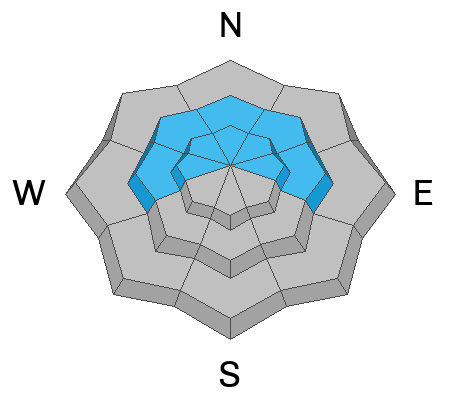
Today the combination of snowfall and very strong winds will create a CONSIDERABLE avalanche danger at upper elevations where slabs of wind drifted snow should be easy to trigger. Also watch for fresh wind slabs at middle elevations where the avalanche danger is MODERATE. Triggering an avalanche at low elevations will be unlikely because there just isn't much snow and the danger is LOW.
The challenge today will be finding slopes with enough snow to ride which means going to higher elevations, but few slopes at upper elevations will be untouched by winds.
Low
Moderate
Considerable
High
Extreme
Learn how to read the forecast here
Special Announcements
Many ski areas are now closed to uphill travel in order to prepare for winter operations. Resort uphill travel policies can be found HERE.
Weather and Snow
This morning it's really warm and really windy with some rain and snow starting to fall as I type. Temperatures are mostly in the upper 30s and low 40s F with the freezing line near 9000 ft. Winds from the south are averaging 20-30 mph and gusting to 40 mph. At 11,000 ft, winds are gusting to 60 mph.
Today the National Weather Service has issued a Winter Storm Warning until midday Thursday for heavy snowfall and high winds. There will be two periods of snowfall. One will occur from about 7 a.m. until noon when 1-2 inches of snow should fall above 8000 feet. There is uncertainty about the exact rain/snow line. Scroll to the bottom for a graphic about this uncertainty. The second and heaviest period of snowfall will occur tonight with about 4-8 inches of dense snow accumulating along with some of the strongest south winds gusting up to 85 mph.
Tomorrow winds will drop considerably as will temperatures. The rain/snow line should drop to valley floors with mountain temperatures in the teens F. Light snowfall should continue through most of Wednesday.

Snow depths in the Provo area mountains around the 8000 ft level are 10-15 inches. Higher elevations may have 2 feet.
Recent Avalanches
There have been no avalanches reported in the Provo area; however, there were some small soft slab avalanches of wind drifted snow yesterday in the Salt Lake area mountains.
Ad
Avalanche Problem #1
Wind Drifted Snow
Type
Location
Likelihood
Size
Description
Some snowfall this morning combined with very strong south winds will form cohesive slabs of wind drifted snow. These wind slabs should be easy to trigger today. They will mainly be an concern above 9500 ft where the most snow will fall and the strongest winds will occur. Strong winds will blow at mid and low elevations but there won't be as much snow in these places for the wind to transport.
The main way to avoid avalanches today will be to avoid slopes with wind drifted snow.
Additional Information

A Few Things to Remember:
  • Whether you're-hiking, hunting, skiing, boarding, snowshoeing or firing up the snowmachine: be prepared for avalanches
  • Any avalanche can produce serious trauma because of a thin snowpack
  • Hitting rocks and stumps is a real danger. Don't end your season.
  • Treat ski resorts as backcountry terrain and check out the UAC site for resort uphill travel policies

It's never too early to start thinking about avalanches. A few things to consider:
1. Attend USAW and learn more about avalanches and decision making. (scroll down to the bottom of this page for more info and links)
2. Sign up for an avalanche class.
4. Take the all-new online avalanche courses the UAC built for Know Before You Go or take other online courses listed on the KBYG website (Develop skills -> Online Learning).
5. Get your avalanche rescue gear ready for winter. Put fresh batteries in your transceiver and update the firmware. Inspect your shovel and probe. Get your airbag backpack ready by doing a test deployment and update the firmware if it is an electric version.
Sign up for the 15th Annual Utah Snow and Avalanche Workshop (USAW) one night left, November 9th. Sign up and get more info for the second session HERE.
General Announcements

This information does not apply to developed ski areas or highways where avalanche control is normally done. This forecast is from the U.S.D.A. Forest Service, which is solely responsible for its content. This forecast describes general avalanche conditions and local variations always occur.