Forecast for the Provo Area Mountains

Mark Staples
Issued by Mark Staples for
Monday, January 7, 2019
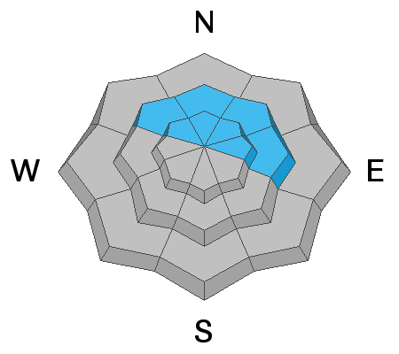
Today the avalanche danger is EXTREME at mid and upper elevations. The avalanche danger is HIGH at low elevations. Avoid all avalanche terrain and avoid being under or near any steep slope. Even very small slopes can bury a person.
Strong south winds combined with over 3 feet of new snow have created very dangerous avalanche conditions.
ANYBODY going into or near the mountains today whether its skiing, snowshoeing, running, sledding, etc. should avoid being near or under any steep slope.
Low
Moderate
Considerable
High
Extreme
Learn how to read the forecast here
Avalanche Warning
THE FOREST SERVICE UTAH AVALANCHE CENTER IN SALT LAKE CITY HAS CONTINUED A BACKCOUNTRY AVALANCHE WARNING.
* TIMING...THROUGH 6 AM MST TUESDAY.
* AFFECTED AREA...FOR THE MOUNTAINS OF NORTHERN UTAH INCLUDING THE WASATCH RANGE, BEAR RIVER RANGE, AND UINTA MOUNTAINS.
* AVALANCHE DANGER...HIGH.
* REASON/IMPACTS...VERY DANGEROUS AVALANCHE CONDITIONS EXIST. HEAVY SNOW COMBINED WITH WIND WILL CREATE WIDESPREAD AREAS OF UNSTABLE SNOW. BOTH HUMAN TRIGGERED AND NATURAL AVALANCHES ARE LIKELY. STAY OFF OF AND OUT FROM UNDERNEATH SLOPES STEEPER THAN 30 DEGREES.
Weather and Snow
Near Provo Canyon and Mt. Timpanogos the combination of yesterday's and today's storm has deposited as much as 3 feet of snow containing 3.22 inches of water. This is a MASSIVE LOAD OF SNOW.
At 6 a.m this morning, snow was falling at a rate of 2-3 inches per hour which is rapid loading.
Strong south winds were blowing 20-30 mph at low and mid elevations. At upper elevations south winds were gusting 60-70 mph.
Today strong winds and snowfall will continue through the morning.
Recent Avalanches
One very large natural avalanche on Mt Timpanogos in the backcountry terrain near Sundance was reported. It ran the full path and crossed a large flat area.
Trent and I rode in American Fork Canyon yesterday on both the Alpine Loop and above Tibble Fork Reservoir. We spotted many shallow slab avalanches on road cuts. We triggered a few and found one triggered by a deer or moose (photo below).
Ad
Avalanche Problem #1
Wind Drifted Snow
Type
Location
Likelihood
Size
Description
With more snow falling this morning and strong south winds blowing, any slope with wind drifted snow will produce slab avalanches today. Some can be triggered by people. Some will occur on their own. Winds can load a slope 10x faster than snowfall alone and the combination of winds and snowfall will make any wind-loaded slope very dangerous to be near or under.
Even though winds are blowing from the south, slopes at any aspect and elevation can be affected. Look for signs of recent wind loading such as smooth, rounded, pillowly deposits of snow.
Avalanche Problem #2
New Snow
Type
Location
Likelihood
Size
Description
Avalanches may also occur on slopes not affected by the wind as Trent and I saw yesterday. Any steep slope or road cut was easy to trigger either a sluff or a soft slab avalanche in the new snow. The photo below shows a tiny road cut that buried half of a snowmobile. Imagine what a slightly bigger slope could do. It would be easy to bury a person.
Avalanche Problem #3
Persistent Weak Layer
Type
Location
Likelihood
Size
Description
With the current load of snow which will be approaching 3 inches of water weight, all bets are off as to how the snowpack will react. There are persistent weak layers of sugary, faceted snow crystals near the ground and also buried 2-3 feet deep just under the new snow. These weak layers can produce large slab avalanches that can be triggered from some distance away or even from flat terrain under a steep slope.
General Announcements
This information does not apply to developed ski areas or highways where avalanche control is normally done. This forecast is from the U.S.D.A. Forest Service, which is solely responsible for its content. This forecast describes general avalanche conditions and local variations always occur.