Forecast for the Provo Area Mountains

Drew Hardesty
Issued by Drew Hardesty for
Thursday, January 31, 2019
Most terrain has an overall LOW danger. Isolated areas of MODERATE danger exist for triggering deeper avalanches into old snow layering. Loose wet activity is possible on the steep sunlit slopes with daytime warming.
Low
Moderate
Considerable
High
Extreme
Learn how to read the forecast here
Special Announcements
The report from last Friday's avalanche accident in the La Sals is finished and can be found HERE. Our deepest condolences go out to the family and friends affected by this accident.
New blog post - I AM Dangerous (link). This is a conversation/collaboration with the writer Molly Absolon in the Tetons. Thanks Molly.
Weather and Snow
Skies are clear, ain't it a shame.*
Mountain temps are in the mid 20s.
Winds are west-northwesterly, blowing 5-10mph.
In 1976, Dave Hanscom and Alexis Kelner published Wasatch Tours, a backcountry skiing guidebook "intended for a rather limited population of skiers who practiced their sport mostly in the proximity of the Central Wasatch". They later published two complementary books that expanded into terrain outside of the central Wasatch. Each are a gem (the books as well) and the reader quickly grasps the passion and love of skiing that each brought to these wonderful books. In their books, they recommend - when the avalanche conditions are suitable - a SuperTour - a long outing among the high peaks and covering lots of ground. I hope you've gotten yours. (pc:McLean)
Recent Avalanches
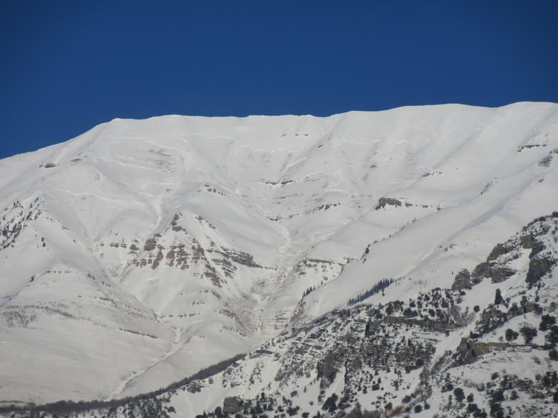
None. We continue to find large natural avalanches from during or just after the blockbuster weather event on the 17th and again on the 21st. The largest natural noted on the western flank of Timpanogos but others noted in the Cascade and Mill Canyon Peak areas. (pc: UDOT Provo Canyon)
Ad
Avalanche Problem #1
Persistent Weak Layer
Type
Location
Likelihood
Size
Description
In isolated areas, it may be possible to trigger an avalanche into older snow layering. Poor to fair structure (weak snow and/or weak snow/crust layering) is present around the compass at most aspects and elevations, particularly above about 8000'. It is recommended to approach steep rocky slopes with caution and stop to gauge the localized stability with various snow tests. Collapsing and cracking may not be present. Many slopes have avalanches and filled back in, adding to the high levels of spatial variability across the southern ramparts of the Wasatch Range (including the Wasatch back).
All Provo observations can be found here.
Additional Information
* Our avalanche center office has long been co-located within the National Weather Service building out on west North Temple. In the very early part of the forecast shift, I'll wander out to look at the weather models on the AWIPS (Advanced Weather Interactive Processing System) and hem-and-haw over the various weather products. This morning, I saw what you see below and said, "Now that is a beautiful thing." (And the lead weather forecaster just laughed).
A powerful series of storms are on the doorstep. We'll see increasing clouds and southerly winds Friday night ahead of a long and complicated storm...that lasts perhaps until Wednesday. The early part of the storm moves in on a southwesterly flow with perhaps an initial rain/snow line to 8-8500'. Snow should begin in earnest on Sunday with continued significant snowfall Monday into Tuesday. The flow looks to remain southwesterly to westerly until Tuesday morning when the flow shifts to the northwest. 2-3'+ is expected by Tuesday afternoon. Possibly more.
General Announcements
This information does not apply to developed ski areas or highways where avalanche control is normally done. This forecast is from the U.S.D.A. Forest Service, which is solely responsible for its content. This forecast describes general avalanche conditions and local variations always occur.