Forecast for the Ogden Area Mountains

Mark Staples
Issued by Mark Staples for
Tuesday, March 29, 2022
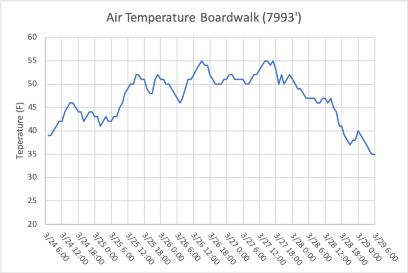
What a mess of conditions today! Mostly the snow is wet making wet avalanches the main problem today. There is also a buried persistent weak layer in places that hasn't gone away. This layer is likely wet and will remain unstable until it gets totally saturated or refreezes.
The avalanche danger is MODERATE at all elevations and aspects because avalanches remain possible. Wet snow under these conditions is not as predictable as it is when we are under an normal cycle of melting and refreezing. The snow did not refreeze overnight and has a weak layer of facets in some places. Personally, I'd just avoid all avalanche terrain today because there's a lot of risk and uncertainty but little reward.
Low
Moderate
Considerable
High
Extreme
Learn how to read the forecast here
Special Announcements
Two generous UAC supporters are challenging the community to invest in the future of the UAC’s forecasting program during the 2022 Spring Campaign. They will match your donation, dollar for dollar, up to $10,000.
Weather and Snow
Current weather: Last night around midnight, temperatures dropped below freezing at elevations above 9000'. Most places have temperatures hovering near 35 deg F. Winds are blowing 5-18 mph from the southwest. A trace to an inch of snow has fallen near Powder Mountain.
Today's weather: Temperatures may climb a few degrees today but mostly be in the mid to upper 30s F. By mid morning, winds should shift and blow from the northwest and increase to 20-30 mph by this afternoon. Snow will fall on and off through the day with the rain/snow line hovering near 8000'. There should be brief periods of heavy snowfall and possibly some lightning, but only 1-3 inches of snow should fall today with a few more falling overnight.
Snow conditions: The snow is generally wet and may only be refrozen on the surface at the highest elevations. Total snow depths in the Ogden area range from 19 inches at 6000' on Ben Lomond Peak, to 50 inches at Monte Cristo near 9000', to 44 inches at Snowbasin, and 42 inches at Powder Mountain.
Image below shows air temperatures at the Boardwalk Station at Snowbasin which hasn't seen below freezing air temperatures since Wednesday morning of last week.
Recent Avalanches
There have been no recent reports from the backcountry, but snow safety teams have reported wet loose avalanches in closed terrain during the last few days.
Ad
Avalanche Problem #1
Wet Snow
Type
Location
Likelihood
Size
Description
It has been nearly a week without below freezing air temperatures. The snowpack has refrozen some nights with clear skies, but with a cloudy skies and a bit of rain/drizzle this morning in places, it should be mostly wet. Without strong sunshine today, wet avalanches may need some other trigger to occur. If it starts raining, that would be a good trigger. They should be mostly wet loose avalanches, but it's hard not to rule out a wet slab avalanche on more northerly aspects where a buried persistent weak layer of facets will be wet.
Otherwise, the only place to find a refrozen snow surface will be above 9000 ft.
Avalanche Problem #2
Persistent Weak Layer
Type
Location
Likelihood
Size
Description
You can still trigger slab avalanches 1-3' deep on our Jan/Feb drought layer of facets, especially on mid-to upper elevation north to northeast facing slopes. We haven't heard of any avalanches on this layer in some time. However, there is plenty of uncertainty with this layer likely being wet today.
Avalanche Problem #3
Wind Drifted Snow
Type
Location
Likelihood
Size
Description
Snow falling today may be transported by increased winds from the north and northwest late today. Watch for a few soft slabs of wind drifted snow under ridgelines and other terrain features at the highest elevations.
General Announcements
Who's up for some free avalanche training? Get a refresher, become better prepared for an upcoming avalanche class, or just boost your skills. Go to https://learn.kbyg.org/ and scroll down to Step 2 for a series of interactive online avalanche courses produced by the UAC.
This information does not apply to developed ski areas or highways where avalanche control is normally done. This forecast is from the U.S.D.A. Forest Service, which is solely responsible for its content. This forecast describes general avalanche conditions and local variations always occur.