

Forecast for the Ogden Area Mountains

Issued by Evelyn Lees on
Saturday morning, February 2, 2019
Saturday morning, February 2, 2019
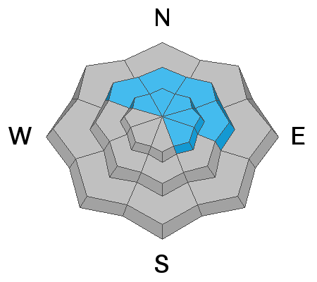
TODAY: The Avalanche Danger is MODERATE on mid and upper elevation slopes facing northwest through easterly for triggering a new wind slab. Small wet, loose sluffs may be triggered on lower to mid elevation shady slopes if it rains this afternoon.
TONIGHT and SUNDAY: Avalanche danger will rise to CONSIDERABLE OR HIGH, with about a foot of new snow and very strong winds. Natural avalanches will become likely. For an early morning update Sunday, call the telephone hot line at 1-888-999-4019, option 6, updated around 5 am.

Low
Moderate
Considerable
High
Extreme
Learn how to read the forecast here
 Special Announcements
New blog post - I AM Dangerous (link). This is a conversation/collaboration with the writer Molly Absolon in the Tetons. Thanks Molly.
 Weather and Snow
A warm, wet storm will slam into northern Utah, bringing a moderate amount of heavy wet snow, some low elevation rain, and extremely strong winds tonight ahead of a Sunday morning cold front. A second colder storm will bring periods of snow Sunday night through Tuesday. Significant portions of both these storms will be on a southwesterly flow, which is a great snow producer for the Ogden area mountains.
Now, 6 am: under partly cloudy skies, the southerly winds are already cranking - averaging to 35 mph at the mid elevations, with gusts to 60 mph. The high ridge lines have already hit 45 to 50 mph averages, with gusts to 70. Temperatures are in the upper 20s to upper 30s.
Today: the southerly winds will remain strong - 35 mph averages, with gusts to 60 mph at the mid elevations, and 50 mph averages, with gusts to 75+ at the upper elevations. 1-3” of snow late this afternoon, with rain to about 7,500’. Temperatures warming into the mid 30s to mid 40s.
Tonight: 8 to 14” of snow possible, with VERY STRONG southwesterly winds - 40 to 55 mph averages, with gusts 70 to 100 mph. Temperatures cooling into the twenties.
 Recent Avalanches
No new avalanches reported yesterday.

Avalanche Problem #1
Wind Drifted Snow
Type
Location
Likelihood
Size
Description
The increasingly strong winds will move snow today, forming sensitive drifts at the mid and upper elevations. On the shadier, northwest through southeasterly facing slopes, the new drifts will be sitting on weak, sugary snow. Look for and avoid any smooth, rounded drifts. Shooting cracks in dense or harder snow are a sure sign you've found a wind drift. It will be possible to trigger these drifts from a distance or from below.
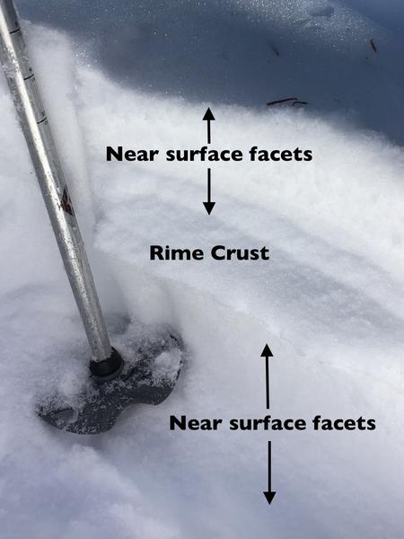
Photo: Ogden area mountains, northerly facing, 8,600' - I expect today's wind drifts to fail on the upper layer on sugary, weak near surface facets. The rime crust and lower facets may become a player tomorrow through Tuesday as the snow continues to pile up.
Cornices may start to grow along the upper and mid elevation ridge lines. Give them a wide berth - travel well back from the edges and avoid travel beneath them.
Avalanche Problem #2
Normal Caution
Type
Location

Likelihood
Size
Description
Wet loose sluffs - with a rain/snow line expected to be around 7,500’ this afternoon, watch for wet loose sluffs if it starts raining where you are. The most sensitive snow will be on shady slopes, where the cold, sugary loose facets won’t like getting wet. Avoid travel on steep slopes when it's raining, including small terrain traps, such as steep siided creek beds and road cuts.
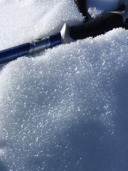
Photo: Ogden area mountains, 7,600', northerly facing. Similar surface hoar all the way down to at least 6,500' and lower on shady slopes. While these slopes will sluff if they get rain on them late today, hopefully the warmth and rain will at least destroy the surface hoar, though the sugary snow beneath will probably remain a weak layer.
The various faceted weak layers in the snowpack may become active once again during this storm cycle, as they get overload by snow and wind drifts. These persistent weak layers vary throughout Utah mountains - check the specific regional forecast of where you plan to travel.
General Announcements
This information does not apply to developed ski areas or highways where avalanche control is normally done. This forecast is from the U.S.D.A. Forest Service, which is solely responsible for its content. This forecast describes general avalanche conditions and local variations always occur.