Join us at our 2nd Annual Blizzard Ball

Forecast for the Ogden Area Mountains

Greg Gagne
Issued by Greg Gagne on
Friday morning, February 16, 2024
The avalanche danger is CONSIDERABLE on all aspects at the mid and upper elevations that have soft slabs of recent or fresh wind-drifted snow. Slopes that aren't wind-loaded and slopes at low elevations have a MODERATE danger.
With increasing winds and periods of heavy snowfall possible, the avalanche danger may rise this afternoon, including possible natural avalanches.
Riding conditions will be superb on lower-angled slopes that aren't wind-affected.
Low
Moderate
Considerable
High
Extreme
Learn how to read the forecast here
Special Announcements
We are seeking a passionate individual to join us as Executive Director of the nonprofit Utah Avalanche Center. Click here for more information.
Weather and Snow
This Morning: Temperatures are 15°-25° F and winds are from the west/southwest and gusting into the teens and 20's mph along exposed mid and upper elevation ridgelines. No new snow overnight.
Snow totals since Wednesday are 12-16" of snow containing up to 1.4" of water.
Today may be one of those days .... temperatures will rise into the 20's F and winds will be from the west, increasing throughout the day. Mid-elevation winds will gust into the 20's with upper elevation winds gusting a mph. Snow will develop by late morning with periods of heavy snow likely and 4-8" of new snow by sunset.
Extended: A break Saturday with partial clearing, followed by another modest system Sunday .... brief break Monday .... snow Tuesday/Wednesday. ❄️
Recent Avalanches
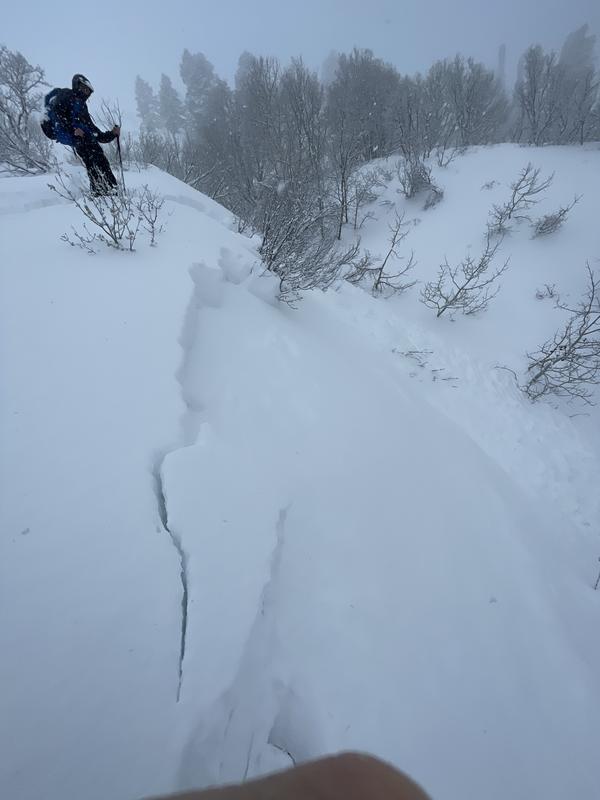
Avalanche activity spiked on Thursday during the period of heavy precipitation intensity (PI) late morning, with natural and skier-triggered avalanches reported. Avalanches were failing within a density inversion in the storm snow or at the interface with the old snow surface. We received an excellent observation from Thursday on Ben Lomond with avalanches up to 18" deep. (Photo below)
All recent reported avalanche activity.
A team of UAC forecasters was in the Snake Creek region in the Provo mountains on Thursday, and their video describes recent avalanche activity and how to assess the snowpack:
Ad
Avalanche Problem #1
Wind Drifted Snow
Type
Location
Likelihood
Size
Description
Moderate to strong winds from the west will have plenty of fresh snow to create soft slabs of wind-drifted snow on all aspects at the mid and upper elevations. These drifts will be 6-18" deep and up to 100' wide. Watch for signs of cracking as an indication of sensitive slabs of wind-drifted or storm snow. Guide and educator John Lemnotis demonstrates how to test for this reactive snow on his split board yesterday in White Pine Canyon:
Avalanche Problem #2
New Snow
Type
Location
Likelihood
Size
Description
Snowfall is forecast to begin this morning,with periods of heavy precipitation possible by late morning. The reactivity of any storm snow is all dependent on snowfall rates: expect sensitive soft slabs of storm snow or long-running sluffs during any period of high precipitation intensity.
Additional Information
We now consider the persistent weak layer in the Ogden area dormant. We have not seen evidence that this layer is reactive, but will continue to assess this layer as the season goes on. If you find faceted snow deeper in the snowpack, please submit an observation.
General Announcements
This information does not apply to developed ski areas or highways where avalanche control is normally done. This forecast is from the U.S.D.A. Forest Service, which is solely responsible for its content. This forecast describes general avalanche conditions and local variations always occur.