Forecast for the Ogden Area Mountains

Trent Meisenheimer
Issued by Trent Meisenheimer for
Thursday, February 15, 2024
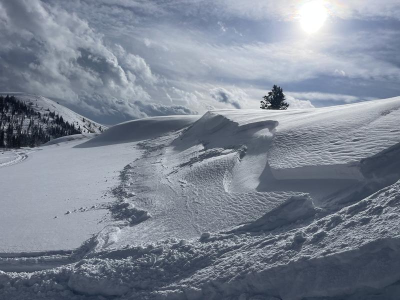
Today, the avalanche danger is CONSIDERABLE on all mid and upper-elevation steep slopes for triggering soft slabs of Wind-Drifted Snow. We also have a CONSIDERABLE danger for New Snow dry-loose (sluffs), or soft slab avalanches failing within the recent storm snow. Strong winds and heavy snowfall will increase the avalanche danger throughout the day. Cautious route-finding and conservative decision-making will be essential today.
Low
Moderate
Considerable
High
Extreme
Learn how to read the forecast here
Weather and Snow
This morning, it's snowing, with rates already at 1" per hour. Since 2 am we have already seen 4-8 inches of new snow with 0.2-0.6 water. Overnight, the southerly winds picked up and continue to blow 15-25 mph with gusts into the 30s & 40s this morning across the upper elevations. Mountain temperatures range from 20-25 °F.
Today, we should see 5-12 inches of new snow throughout the day, with the peak intensities happening mid-morning. The wind will continue to blow from the southwest at 15-25 mph with gusts into the 30s and 40s for much of the day. At some point, the wind will veer to the west and eventually blow from the northwest later today. The storm will be short-lived but should stack up 10-15 inches of new snow by Friday afternoon.
This weekend a large closed low sets up off the California Coast and looks to park there for a few days. This closed low will usher in a moist southwest flow and, depending on where the waves of moisture hit, will determine how much snow we get. But this storm looks to be warm and wet.
Recent Avalanches
Mark Staples was in Bountiful and was able to trigger a shallow but wide wind slab off an upper elevation ridge. The avalanche was roughly 200 feet wide failing on buried stellar snow (photo below). Brian Smith was able to get the wet surface snow to slide easily on the old hard crusts (wet-loose). That problem should not be an issue today.
Ad
Avalanche Problem #1
Wind Drifted Snow
Type
Location
Likelihood
Size
Description
We have now seen close to 24 hours of elevated wind speeds from the southwest. This morning, the southwest wind continues to blow at speeds of 15-25 mph with gusts in the 30s and 40s. These are the perfect speeds to drift snow onto lee slopes. With wet heavy snowfall throughout the day and plenty of soft, dry snow to blow around I would expect to find soft slabs of wind-drifted snow across all mid and upper-elevation steep terrain. These slabs could be 1-3 feet deep and up to 200 feet wide.
Heads up: We have been finding buried surface hoar and small-grained faceted snow in sheltered locations (see Hardesty/Meisenheimer observation). Plus we have this weekends very low-density snow (2-3%) that is now buried and preserved (stellar crystals). If any of those grains come into play, the soft slab or wind slab will be much more electric.
Avalanche Problem #2
New Snow
Type
Location
Likelihood
Size
Description
This avalanche problem will depend on the storm and how the new snow falls from the ski. If we see snowfall rates of 1" per hour or more this morning I would expect to see widespread dry-loose avalanches as well as soft slabs failing within the new storm snow or at the old/new snow interface. I would be cautious as the new snow stacks up. Use shovel tilt tests or small tests slopes to see how the new snow is bonding before committing to steep terrain.
Additional Information
We are now considering the persistent weak layer in the Ogden area dormant. We have not seen evidence that this layer is reactive. We will continue to assess this layer as the season goes on. If you find faceted snow, do snowpit tests, and please submit an observation.
General Announcements
This information does not apply to developed ski areas or highways where avalanche control is normally done. This forecast is from the U.S.D.A. Forest Service, which is solely responsible for its content. This forecast describes general avalanche conditions and local variations always occur.