Fall Auction is now live! Check it out now

Forecast for the Ogden Area Mountains

Mark Staples
Issued by Mark Staples on
Wednesday morning, December 4, 2019
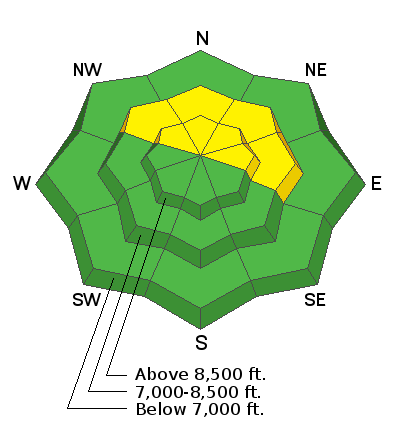
Today the avalanche danger is MODERATE on mid and upper elevation northerly and east-facing slopes. Recent warm weather has strengthened the snowpack but triggering an avalanche on old weak snow near the ground or a slab of wind drifted snow remains possible. All other slopes have a LOW avalanche danger.
Low
Moderate
Considerable
High
Extreme
Learn how to read the forecast here
Special Announcements
Welcome to the First Annual Avalanche Awareness Week. We hope to see you at one of the 20 scheduled events. Check out the schedule here.
Need a Christmas present for your favorite backcountry partner? Get one of these cool t-shirts to support the UAC and other avalanche centers across the U.S.
The first UAC podcast of the season " Early Season Essentials with Program Director Bo Torrey" check it out HERE.
Weather and Snow
Temperatures started warming this morning around 1 a.m. and were in the low 30s F below 8000 feet although there is a slight inversion with colder temps at some low elevations. Near 9000 feet temperatures were in the mid to upper 20s F.
Winds shifted around 1 a.m. to a more southerly direction and were blowing 5-10 mph. Stronger ridgetop winds were blowing near Snowbasin at 15-20 mph from the SSW.
Recent warm weather has shrink wrapped the snowpack with settled snow depths about 2 feet in most places. Yesterday's warm temperatures and sunshine dampened the snow surface and even led to some roller balls and pinwheels on southerly facing slopes.
Today will be partly sunny as a quickly moving storm approaches from the southwest. Temperatures today could warm into the upper 30s F but hopefully clouds limit that warming. Precipitation shouldn't arrive until tonight with some rain possible at elevations up to 7000 feet. Above that elevation only 1-3 inches of snow should fall. A better chance for snow arrives Saturday night into Sunday.
Recent Avalanches
A few small avalanches were triggered by ski patrols yesterday on NE aspects above 8000 feet including a few shallow wind slabs.
Ad
Avalanche Problem #1
Persistent Weak Layer
Type
Location
Likelihood
Size
Description
Weak facets and old snow still exist near the ground on upper elevation northerly facing slopes and could produce a slab avalanche. Recent warm temperatures have dampened the snowpack and likely helped this layer gain strength; however, the terrain where this layer could remain a problem is also where the snowpack remains the coldest.
I would be hunting for this layer which is most likely found just on top of an old ice crust near the ground (Greg discusses the layering in this video). Since the snowpack is still shallow, it doesn't take much work to dig to the ground and perform stability tests.
Avalanche Problem #2
Wind Drifted Snow
Type
Location
Likelihood
Size
Description
Strong southerly winds on Sunday and Monday formed slabs of wind drifted snow. Ski patrols were able to pry out a few of these wind slabs yesterday. With the recent warm weather, most wind slabs have likely bonded to the underlying snow. Triggering one remains possible, and I would still be watching for and avoiding them. Besides, slopes with wind slabs won't have the best riding conditions so why take a chance.
Read more about how to identify slabs of wind drifted snow HERE.
Additional Information
General Announcements
This information does not apply to developed ski areas or highways where avalanche control is normally done. This forecast is from the U.S.D.A. Forest Service, which is solely responsible for its content. This forecast describes general avalanche conditions and local variations always occur.
Remember your information can save lives. If you see anything we should know about, please help us out by submitting snow and avalanche conditions. You can also call us at 801-524-5304, email by clicking HERE, or include #utavy in your tweet or Instagram.
To get help in an emergency (to request a rescue) in the Wasatch, call 911. Be prepared to give your GPS coordinates or the run name.
Backcountry Emergencies. It outlines your step-by-step method in the event of a winter backcountry incident.
If you trigger an avalanche in the backcountry, but no one is hurt and you do not need assistance, please notify the nearest ski area dispatch to avoid a needless response by rescue teams. Thanks.
Salt Lake and Park City – Alta Central (801-742-2033), Canyons Resort/PCMR Dispatch (435-615-1911)
Ogden - Snowbasin Resort Dispatch (801-620-1017), Powder Mountain Dispatch (801-745-3772 x 123)
Provo - Sundance Dispatch (801-223-4150)