Forecast for the Ogden Area Mountains

Trent Meisenheimer
Issued by Trent Meisenheimer for
Sunday, December 10, 2023
Across all upper elevations, you will find a MODERATE avalanche danger for wind-drifted snow where soft slabs 1-2 feet deep could be sensitive to the weight of humans.
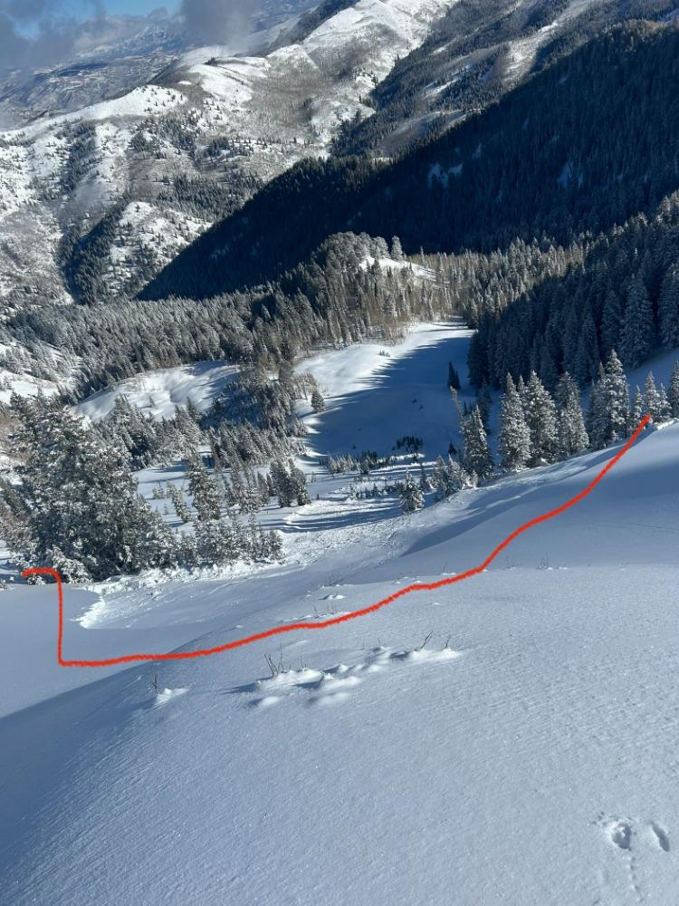
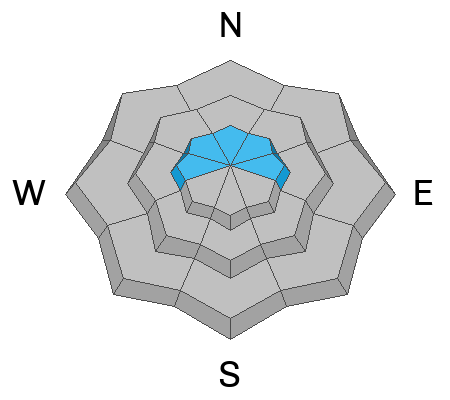
The avalanche danger is MODERATE on steep west-to-north and east-facing slopes above about 8,500' where it's possible to trigger a slab avalanche that could break 1-3 feet deep and hundreds of feet wide because of a buried persistent weak layer.
Natural avalanches are unlikely, while human-triggered avalanches are possible.
Low
Moderate
Considerable
High
Extreme
Learn how to read the forecast here
Weather and Snow
Under partly to mostly cloudy skies, the mountain temperatures range from 20-25°F. Unfortunately, the west winds picked up overnight and continue to blow 10-20 mph, gusting into the 30s across the mid and upper elevation ridgelines. Across the Ogden Skyline, the winds blow steady from the west at 25-30 mph.
Riding and turning conditions are about as good as they get for the early season, with powder snow on almost all aspects and elevations. There might be a slight melt-freeze crust on the solar aspects this morning. Otherwise, travel is easy. Storm totals from the past few days:
  • Little Cottonwood: 23-28" snow (1.6-1.8" water)
  • Big Cottonwood: 15-22" snow (1.2-1.6" water)
  • Park City Ridgeline: 10-16" snow (1-1.4" water)
  • Ogden Mountains: 10-14" snow (0.8-1.4" water)
Recent Avalanches
No new observations from the Ogden area. Yesterday in the central Wasatch, one avalanche caught my attention in the Wilson Chutes in Millcreek Canyon (photo below). This was a remotely triggered (from a distance) avalanche that failed on a Persistent Weak Layer. The avalanche was two feet deep, 125 feet wide, and ran into the flats below. What's alarming is this avalanche was triggered remotely, which tells me it is still possible to trigger slab avalanches today. C
Ad
Avalanche Problem #1
Wind Drifted Snow
Type
Location
Likelihood
Size
Description
Overnight, the northwest winds picked up and there is plenty of snow available to blow around. Be cautious and on the lookout for new soft slabs of wind-blown snow. I would suspect these new wind slabs could be sensitive to the weight of riders today. Look for and avoid areas where the snow has been drifted or is actively being drifted by the wind.
Remember, any avalanche that you trigger on the north side (shady side) of the compass has the potential to step down into weaker layers below (see persistent slab discussion below).
Avalanche Problem #2
Persistent Weak Layer
Type
Location
Likelihood
Size
Description
On slopes facing west to north to east at the upper elevations, you will find weak and faceted snow at the base of the snowpack. This weak snow has been the persistent weak layer in many avalanches across northern Utah for the last ten days.
As the snowpack adjusts to the load (storm snow), the likelihood of triggering an avalanche decreases with time. However, the size and consequence of the avalanche will remain the same. Notice the likelihood and size slider bars to the left.
As time passes, this weak layer will gain strength and become a thing of the past. However, yesterday's recent avalanche in the Wilson Chutes shows this problem still exists. Places where the snowpack is generally less than about 3 feet deep (ski pole), will be the most suspect.
For me, it's easy. I DO NOT trust faceted snow in any capacity. Therefore, I avoid slopes with this structure until the faceted snow goes away. If I were riding steep terrain, I would stick to the sunny aspects where this layer does not exist.
General Announcements
This information does not apply to developed ski areas or highways where avalanche control is normally done. This forecast is from the U.S.D.A. Forest Service, which is solely responsible for its content. This forecast describes general avalanche conditions and local variations always occur.