Forecast for the Ogden Area Mountains

Evelyn Lees
Issued by Evelyn Lees for
Thursday, January 24, 2019
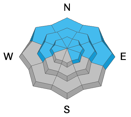
Today wind drifting is the main issue. The avalanche danger is CONSIDERABLE at mid and upper elevations. Low elevations have a MODERATE danger.
Avoid wind loaded slopes and you'll avoid most avalanches. With such a huge load of snow over the last week, the possibility remains for slides to break deeper in the snowpack on buried persistent weak layers. These layers are gaining strength and do not exist everywhere, but are lurking on some slopes.
Low
Moderate
Considerable
High
Extreme
Learn how to read the forecast here
Weather and Snow
The Ogden area mountains picked up a trace to an inch of snow yesterday. Winds once again stole the headlines - the upper elevations were averaging 25 to 35 mph from the southwest. Temperatures are in the teens along the high ridgelines this morning, to the mid twenties and even a 32 degrees at the Ben Lomond trail head. Winds have been decreasing rapidly.
For today, mostly to partly cloudy skies, with temperatures warming into the upper 20s to mid 30s. The northwesterly winds should remain in the 15 to 25 mph averages at the high elevations, but average less than 15 mph elsewhere.
Recent Avalanches
Yesterday, the Ogden area ski patrols were able to trigger some fresh slabs of wind-drifted snow. Some of these were hard slabs large enough to bury a person. Many were smaller wind slabs at mid and upper elevations that were not sensitive to skis.
Ad
Avalanche Problem #1
Wind Drifted Snow
Type
Location
Likelihood
Size
Description
Another wind event yesterday and overnight drifted snow at the mid and higher elevations into another layer of wind slabs. Drifts can be found on almost any aspect, wherever the wind slows and drops it’s snow. The dense, smooth drifts are to the lee of ridgelines and cross-loaded into couloirs, gullies and mid slope break overs. While they may be shallow and stubbon, continue to avoid wind drifted slopes.
Avalanche Problem #2
Persistent Weak Layer
Type
Location
Likelihood
Size
Description
There's good news and bad news. The good news is that any persistent weak layers of facets in the snowpack have gotten buried deep in the snowpack with recent storms. This means they are healing and we are building a strong snowpack. In many places the snowpack is already quite strong overall and no persistent weak layers exist. Yesterday, Mark was in the backcountry north of Snowbasin, and dug 5 snowpits between about 8000 and 7000 feet on northerly aspects and couldn't find any persistent weak layers.
However, the Ogden area mountains have seen some avalanche activity on buried layers of small facets and/or surface hoar. (one good example here). A skier near North Ogden Divide found some of these weak layers Tuesday. If I were skiing or riding today, I'd be looking for these layers. Fortunately you don't need to dig to the ground, dig about 3-4 feet deep. Besides it's good rescue practice.
General Announcements
This information does not apply to developed ski areas or highways where avalanche control is normally done. This forecast is from the U.S.D.A. Forest Service, which is solely responsible for its content. This forecast describes general avalanche conditions and local variations always occur.