Forecast for the Moab Area Mountains

Dave Garcia
Issued by Dave Garcia for
Friday, April 7, 2023
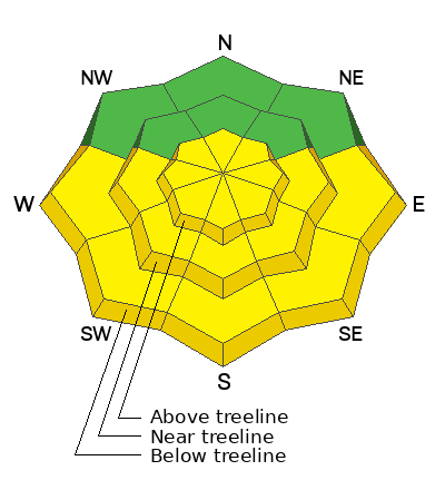
The overall danger is MODERATE. Southerly winds will whip up a fresh round of wind drifts on above treeline slopes that face NW-N-NE-E. Backcountry travelers should pay attention to blowing and drifting snow, and carefully evaluate terrain on the leeward side of high ridge lines where human triggered avalanches will be POSSIBLE.
Strong April sunshine will quickly heat up solar aspects today. Wet avalanche activity is POSSIBLE on steep sun-exposed slopes. Travel on solar aspects early, and head to shady slopes this afternoon to stay safe.
Low
Moderate
Considerable
High
Extreme
Learn how to read the forecast here
Special Announcements
Geyser Pass Road: The road is open. 4x4 recommended.
Grooming: Trails were groomed into Gold Basin on Wednesday.
Weather and Snow
6:00 a.m. Snow and Weather Data
24 Hour Snow 0" 72 Hour Snow 10" Season Total Snow 315" Base Depth at Gold Basin 110"
Temp 23 F Winds on Pre-Laurel Peak: NA

Weather
Under clear skies and a full moon, temperatures are 23 degrees in Gold Basin this morning. Winds on the high ridge lines are blowing around 20 mph out of the South, and will continue to blow in the 15-25 mph range all day. We can expect high temperatures to reach 33 degrees at 10,000 ft. Tomorrow looks to be a repeat of today, sunny and breezy with highs in the low to mid 30's. Sunday stays warm and sunny with temperatures reaching 40 degrees.
General Conditions
Conditions have taken a slight hit from yesterday's strong sun and warm temperatures. Expect to find solar aspects crusted over this morning. Shady slopes should offer plenty of great skiing and riding, with cold settled powder. It is going to be another warm one, and wet avalanche activity will once again be a concern on any steep sun-exposed slope. If you plan to ski the solars, hit them in the morning and then move to the North side of the compass in the afternoon. On steep Northerly slopes in the alpine, you should be on the lookout for lingering wind drifts that may still be sensitive to the weight of a human. Also with the bump in winds today, there is the potential for fresh drifts to form above treeline.

Snowpack and Weather Data
Gold Basin Storm Stake (10,000')
Gold Basin SNOTEL site (10,000')
SNOTEL site near Geyser Pass Winter Trailhead (9600')
Wind Station on Pre-Laurel Peak (11,400')
NWS forecast for the La Sal Mountains.
Recent Avalanches
No recent activity has been reported. See the La Sal avalanche database here.
Ad
Avalanche Problem #1
Wind Drifted Snow
Type
Location
Likelihood
Size
Description
Lingering wind drifts from Tuesday's storm may still be sensitive to the weight of a skier or rider. Most of these drifts should be settled out by now, but the possibility still exists to trigger one of these older drifts in steep Northerly terrain above treeline. We will see a bump in wind speeds today out of the South. Tuesday's storm dropped plenty of low density snow, and backcountry travelers should anticipate fresh wind drifts forming above treeline on slopes with a Northerly component to to their aspect. If you have a big objective in mind today, take note of developing wind slabs on the leeward sides of high ridge lines.
Avalanche Problem #2
Wet Snow
Type
Location
Likelihood
Size
Description
Sun-exposed slopes are going to get a big hit of April sunshine today. You can safely ride solar aspects early this morning, but as the day warms up, you will need to get off the solars and head to the polars to stay safe. Expect to see sunny slopes shedding snow this afternoon. Roller-balls and snow moving down hill is a sure sign that it is time to get off solar aspects. Saturated, slushy snow is another red flag for wet avalanche activity.
Additional Information
This graph is from the Snotel site near the Geyser Pass Winter TH. The black line is our current season. Total SWE is 230% of normal.
General Announcements
This forecast is from the U.S.D.A. Forest Service, which is solely responsible for its content. This forecast describes general avalanche conditions and local variations always occur. This forecast will be updated by 7:30 tomorrow morning.