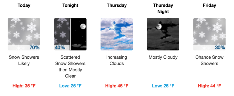
Forecast for the Moab Area Mountains

Eric Trenbeath
Issued by Eric Trenbeath for
Wednesday, April 3, 2019
The avalanche danger is generally LOW. If snow totals come in on the higher end, we may see some new wind drifts developing along upper elevation ridge crests on slopes the face NW-N-E. Loose snow sluffs are also still a possibility on very steep slopes of around 40 degrees. Keep these problems in mind if tagging big, high lines in the La Sals is part of your game plan.
Low
Moderate
Considerable
High
Extreme
Learn how to read the forecast here
Special Announcements
When the forecasting ends, the UAC’s work keeps going strong. Summer is a busy time for the UAC. During the summer we are working hard on our fall and winter planning; putting together the Fall Fundraiser and USAW; updating our awareness and education programs; this summer we will be finishing up the website redesign project. Your donation shows you’re invested in this community all year round! You can still be part of the UAC’s success in 2019. Consider making a donation by April 8.
Weather and Snow
Skies are cloudy, SW ridge top winds are blowing 15-20 mph, and 10,000' temps are in the high 20's. A weak storm system will produce snow showers later today with 1"-3" possible across most of the range. The highest elevations may see 3"-5". SW winds will continue to blow in the 15-20 mph range along ridge tops with some higher gusts.
Sunday's 8"-10" improved conditions dramatically, and good turning and riding can still be found on sheltered northerly aspects. The sun was out in full force on Monday however, and affected slopes will be crusted over.
New snow totals in Gold Basin (10,000')
Snotel totals at the Geyser Pass Trailhead (9600')
Winds at 11,000 feet on Abajo Peak (11,330') about 45 miles south.
National Weather Service point forecast.
Ad
Avalanche Problem #1
Normal Caution
Type
Location
Likelihood
Size
Description
Low danger doesn't mean no danger, especially if you are beginning to set your sites on some of the bigger lines, and more extreme terrain that the La Sals have to offer. Continue to be on the lookout for isolated wind rolls on the leeward sides of high elevation ridge crests and terrain features. Loose snow sluffing on very steep, north facing slopes is also still a possibility. Though mostly shallow, and not very wide, a loose sluff could carry you over a cliff and ruin your day if not your life. Practice safe travel techniques, and carefully evaluate the snow before committing to extreme terrain.
General Announcements
Your information can save lives. If you see anything we should know about, please help us out by submitting snow and avalanche observations HERE. You can also call me at 801-647-8896, or send me an email: [email protected].
Support the UAC through your daily shopping. When you shop at Smith's, or online at REI, Backcountry.com, Patagonia, NRS, Amazon, eBay by clicking on these links, they donate a portion of your purchase to the UAC. If you sell on eBay, you can have your See our Affiliate Page for more details on how you can support the UAC when you shop
This forecast is from the U.S.D.A. Forest Service, which is solely responsible for its content. This forecast describes general avalanche conditions and local variations always occur.