Forecast for the Moab Area Mountains

Eric Trenbeath
Issued by Eric Trenbeath for
Sunday, April 2, 2023
An isolated or MODERATE danger exists, and human triggered avalanches are possible on all aspects and elevations today.

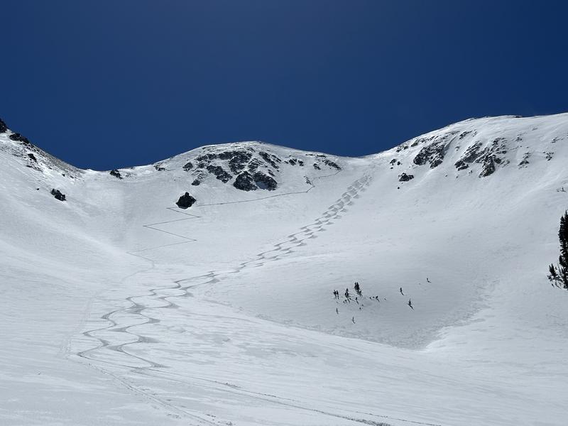
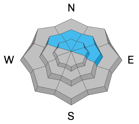
On steep, north through easterly aspects near treeline and above, avalanches involving slabs of wind drifted snow are possible. Look for areas of drifted snow on the leeward sides of ridge crests and terrain features. Even a small wind slab avalanche can be dire in consequential terrain.

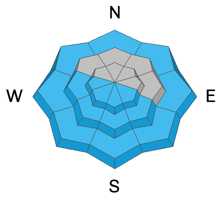
On south through west facing slopes, and on low elevation northerly aspects, the danger for loose wet avalanches will rise as the day heats up. Signs of instability include rollerballs, pinwheels, and sloppy wet snow. Stay off of, and out from under steep slopes where these signs are present.

Cornices are becoming very large in some areas. Give them a wide berth and stay out from under them.
Low
Moderate
Considerable
High
Extreme
Learn how to read the forecast here
Special Announcements
Geyser Pass Road: The road is open. Surface is snowpacked and soft near the top. Warm temps today will make it a sloppy mess on the lower end. 4x4 recommended.
Grooming: The Forest Service groomed into Gold Basin on Saturday.
Weather and Snow
6:00 a.m. Snow and Weather Data
24 Hour Snow 0" 72 Hour Snow 7" Season Total Snow 301" Base Depth at Gold Basin 105"
Temp 27° F Winds on Pre-Laurel Peak: SW 25-30 G 40

Weather
Another sunny, warm, and windy day is on tap. High temps at 10,000' will be around 40°F, and SW winds will blow in the 20-30 mph range while increasing throughout the day. Clouds begin to move in tonight ahead of a low pressure system dropping in from the Pacific NW. Monday will see very high winds and developing scattered snow showers. The bulk of this system will impact areas to the north, but we should see snow Monday night into Tuesday, with 5"-7" possible. Unseasonably cool and unsettled weather continues through the week with hints of a warm and drying trend by the weekend.

General Conditions
The effects of sun and wind were on full display in the mountains yesterday but good snow can still be found on sheltered, northerly aspects. It was a busy day in the mountains and some big lines were getting skied without incident. Isolated areas with potentially unstable slabs of wind drifted snow still exist however, and winds today will keep the threat alive. If you venture into high, alpine terrain, be sure you know how to identify and avoid potentially unstable slabs of wind drifted snow. Even a small avalanche could have serious consequences in areas of more extreme terrain.
As the day heats up, you will again need to be on the lookout for loose wet avalanches. Signs of instability include rollerballs, pinwheels, and sloppy wet snow. Stay off of, and out from under steep slopes where these signs are present.
And finally, cornices have grown huge in some areas. Give them a wide berth and stay out from under them.
Forecaster Dave Garcia found the goods on his day off yesterday. He reported wind affected snow on a nearby slope as well as isolated areas of wind slab that they were able to navigate around. Pay attention to changes in snow conditions on your ascent, especially if things suddenly feel dense or slabby. Minimize your risk on the descent by skiing one at time. Have an escape route and an established safe place to regroup. Check terrain features such as steep convexities with a slope cut, don't just blindly launch over them.

Snowpack and Weather Data
Gold Basin Storm Stake (10,000')
Gold Basin SNOTEL site (10,000')
SNOTEL site near Geyser Pass Winter Trailhead (9600')
Wind Station on Pre-Laurel Peak (11,400')
NWS forecast for the La Sal Mountains.
Recent Avalanches
No recent avalanches have been reported. See the La Sal avalanche database here.
Ad
Avalanche Problem #1
Wind Drifted Snow
Type
Location
Likelihood
Size
Description
Strong southerly winds continue to create slabs of drifted snow on leeward slopes near treeline and above. Though not widespread, slabs of drifted snow 8"-18" deep can be found, primarily on north through easterly aspects right around treeline and above. Look for recent drifts on the leeward sides of ridge crests and terrain features such as gully walls, sub ridges, and rocky outcrops. Suspect slopes that have a smooth, rounded appearance. Cracking is a sign of instability. Even a small wind slab avalanche could have serious consequences in the wrong terrain.
Avalanche Problem #2
Wet Snow
Type
Location
Likelihood
Size
Description
As the day heats up, the danger for loose, wet avalanches will be on the rise. Southeasterly facing slopes will heat up first followed by south and finally west. Low elevation, northerly aspects may also get in on the action. Signs of instability include rollerballs, pinwheels, and sloppy wet snow. Stay off of, and out from under steep slopes where these signs are present.
Additional Information
Sorry bikers, it's going to be awhile!
General Announcements
This forecast is from the U.S.D.A. Forest Service, which is solely responsible for its content. This forecast describes general avalanche conditions and local variations always occur. This forecast will be updated by 7:30 tomorrow morning.