Forecast for the Moab Area Mountains

Eric Trenbeath
Issued by Eric Trenbeath on
Friday morning, April 10, 2020
With a strong sun and warm temperatures, the danger for wet avalanches will rise to MODERATE today. Signs of instability include pinwheels, rollerballs, and point release sluffs. Get off of and out from under steep slopes that become wet and sloppy. And though the chances are decreasing, a MODERATE danger still exists for deep and dangerous, human triggered avalanches failing on a buried persistent weak layer of loose, sugary, faceted snow primarily on slopes facing NW-N-E. Avoid steep, wind drifted slopes and likely trigger points such as steep convexities or shallow snowpack areas near rock outcroppings or sub ridges.
Low
Moderate
Considerable
High
Extreme
Learn how to read the forecast here
Special Announcements
This will be the last weekend for regularly scheduled forecasts.
Road Conditions: The road is mostly dry. Some mud and snow exists near the upper end.
Grooming: Grooming has been suspended for the season.
The Avalanche Research Program at Simon Fraser University is conducting an online survey to examine how people use avalanche safety information. They want to hear from all backcountry users to understand how they process information provided in public avalanche forecasts. Anyone who completes the survey before May 15th will be entered to win cash prizes.

Uncertainty, Risk, & Decision Making: before, during, and after COVID-19 - Read this thought-provoking blog post about how we take risks by guest author Tom Diegel.
Weather and Snow
24 Hour Snow 0" Weekly Snow 0" Base Depth in Gold Basin 63" Wind SE 10-15 Temp 25F
Wind, temperature, humidity on Pre Laurel Peak (11,700')
Storm totals at Gold Basin Study Plot (10,000').
Snotel site near Geyser Pass Trailhead (9600').
NWS weather forecast
Weather: Skies are clear and we got a good re-freeze last night. Look for sunny skies today, light SW winds, and high temps near 50 degrees. Saturday also looks warm and dry. On Sunday, a weak but cold system will drop in from the north bringing clouds and a very slight chance for snow showers. Temperatures will crash as we remain under a cold, NW flow through Wed.
Snowpack: With a good re-freeze last night we should see a return to corn snow conditions today. Maggie Nielsen was up Wednesday and reported good corn snow on a SW aspect at around 10,500'. She also detailed a complex snowpack with isolated collapsing in shallow snowpack areas at lower elevations. Read her observation here.
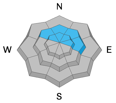
I've been observing a strengthening snowpack on northerly aspects and stability tests are not producing results on the faceted weak layer from February. Spatial variability is still a key component however, and there are still places where weak facets can be found beneath a slab that is 2'-4' thick. Avoid steep wind loaded slopes and shallow areas in the alpine or right around treeline. Likely trigger points include steep convexities and areas around rock outcroppings, sub ridges, or along slope margins. The more radical the terrain, the greater the likelihood for triggering an avalanche, and I'm still not feeling all that confident about steep, north-facing terrain.
Ad
Avalanche Problem #1
Wet Snow
Type
Location
Likelihood
Size
Description
With a strong sun and warm temperatures, the danger for wet avalanches will rise throughout the day. Signs of instability include pinwheels, rollerballs, and point release sluffs. Get off of and out from under steep slopes that become wet and sloppy.
Avalanche Problem #2
Persistent Weak Layer
Type
Location
Likelihood
Size
Description
Though the odds are decreasing, it is still possible to trigger a deep and dangerous avalanche failing on a persistent weak layer of loose, sugary facets that formed in February. Significant snowfall and strong winds have built slabs 2'-4' deep over top of this weak snow. You are most likely to trigger an avalanche involving this persistent weak layer on steep, wind loaded, north through easterly facing slopes right around treeline, or in shallower, rocky areas in the alpine. Avoid likely trigger points such as steep convexities or thinner snowpack areas around rock outcroppings.
Additional Information
Information on outdoor recreation - The State of Utah created this webpage with information about recreating on both state and federal public lands during the current health crisis.

New to the backcountry (including riding at closed resorts) - Watch the award-winning, 15 minute Know Before You Go video, or take the 5-part, free online-learning series.
General Announcements
We've closed down the beacon park for the season. Thanks to volunteers Evan and Maureen Clapper for helping me with that!
This forecast is from the U.S. Forest Service, which is solely responsible for its content. This forecast describes general avalanche conditions and local variations always occur.