Forecast for the Moab Area Mountains

Eric Trenbeath
Issued by Eric Trenbeath on
Tuesday morning, March 31, 2020
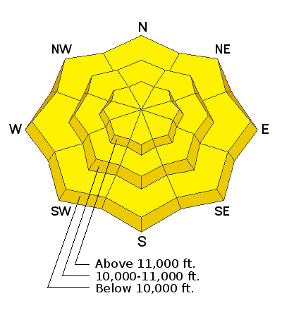
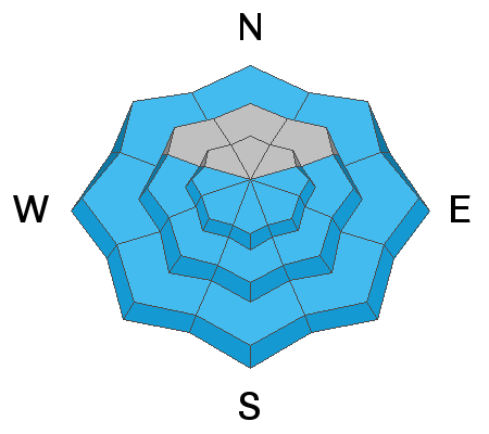
A MODERATE danger still exists for human triggered avalanches involving wind drifted snow primarily on upper elevation, northerly facing terrain. Northerly aspects also still harbor a MODERATE danger for deeper and more dangerous avalanches failing on a buried persistent weak layer of loose, sugary, faceted snow. Avoid steep, wind drifted slopes and likely trigger points such as steep convexities or shallow snowpack areas near rock outcroppings. And finally, with a strong sun and warm temperatures, the danger will rise for loose, wet avalanches on sun-exposed slopes. Look for signs of instability such as pinwheels, rollerballs, and point release sluffs, and get off of and out from under steep slopes that become wet and sloppy.
Low
Moderate
Considerable
High
Extreme
Learn how to read the forecast here
Special Announcements
Road Conditions: The road has not been plowed but lots of traffic has been up. Expect snow on the upper end with conditions turning muddy and sloppy as the day heats up.
Grooming: Trails have not been groomed.
Spring Awareness Campaign - Help us save lives through avalanche forecasts and education. Consider making a donation before April 8th.

Information on outdoor recreation - The State of Utah created this webpage with information about recreating on both state and federal public lands during the current health crisis.

January 5, 2019 - Read this collection of 6 stories and a podcast about that day with a low avalanche danger, 8 skier triggered avalanches, four catch and carries...a partial and critical burial, and a trip to the emergency room.
Weather and Snow
24 Hour Snow T" Weekly Snow 12" Base Depth in Gold Basin 70" Wind SW 10-20 Temp 18F
Wind, temperature, humidity on Pre Laurel Peak (11,700')
Storm totals at Gold Basin Study Plot (10,000').
Snotel site near Geyser Pass Trailhead (9600').
NWS weather forecast
Weather: Trace amounts of snow fell in the mountains yesterday and NW winds were mostly light. Winds shifted to the SW overnight and bumped up into the 15-20 mph range. Today look for sunny skies and very warm temperatures with highs reaching up into the mid 40's. Wednesday will also be sunny and warm with increasing southwesterly winds. A Pacific low will produce clouds and a chance for snow on Thursday though most of the energy will be to the north.
Snowpack: Southerly winds on Sunday continued to blow and drift the 10"-12" of low-density snow that fell on Friday. March has brought a significant amount of snow with up to 3' falling since the 18th. All of this snow has piled up on a snowpack that in many areas is comprised largely of weak, sugary, faceted snow. Weak snow can be found on all aspects but the weakest snow exists on northerly facing slopes right around treeline and below. Alpine areas generally have a deeper and stronger snowpack, especially out in the middle of concave bowls. However, slope margins, wind-swept areas, and areas right around rocks, cliffs, or sub-ridges have a much thinner snowpack. Weak, faceted snow exists in these areas. The recent spate of natural and human triggered avalanches in the alpine have included areas of wind drifted snow that have propagated into areas with weak, faceted snow.
This video was made last week but if you haven't been following it still summarizes what's been happening up there this month.
Recent Avalanches
No avalanche activity has been reported since last weekend.
Ad
Avalanche Problem #1
Wind Drifted Snow
Type
Location
Likelihood
Size
Description
Southerly winds on Monday continued to blow and drift Friday's 10"12" of low density snow around. These drifts will be less sensitive today but remain on the lookout for recent drifts on the lee sides of ridge crests and terrain features on upper elevation, northerly facing terrain. Avoid steep slopes that look "fat" or that have a smooth, rounded appearance. In these same areas, recent wind drifts have piled up on top of old, and a triggered wind slab has the potential to step down into a buried persistent weak layer causing a deeper and much more dangerous avalanche.
Avalanche Problem #2
Persistent Weak Layer
Type
Location
Likelihood
Size
Description
Up to 3' of snow has fallen in the La Sals since March 18, much of it accompanied by strong southerly winds. This load has fallen on top of a persistent weak layer of sugary, faceted snow that formed in February. Though no avalanches have been reported in more than a week, deep and dangerous, human triggered avalanches 2'-4' deep remain possible. You are most likely to trigger an avalanche involving this persistent weak layer on steep, wind loaded, north through easterly facing slopes right around treeline, or in shallower, rocky areas in the alpine. Avoid likely trigger points such as steep convexities or thinner snowpack areas around rock outcroppings.
Avalanche Problem #3
Wet Snow
Type
Location
Likelihood
Size
Description
With a strong sun and warm temps the danger for wet slide activity will increase today. Signs of instability include rollerballs and pinwheels, and actual loose sluffs or point releases. If you observe any of these signs, or if the snow starts to feel wet and sloppy, it's time to get off of and out from under steep, sun-exposed slopes.
Additional Information
New to the backcountry (including riding at closed resorts) - Watch the award-winning, 15 minute Know Before You Go video, or take the 5-part, free online-learning series.
General Announcements
Check out the avalanche beacon training park at the Geyser Pass Trailhead and practice your rescue skills!
This forecast is from the U.S. Forest Service, which is solely responsible for its content. This forecast describes general avalanche conditions and local variations always occur.