UDOT PLANNED AVALANCHE CLOSURES!!

Forecast for the Moab Area Mountains

Issued by Chris Benson on
Wednesday morning, March 17, 2021
The avalanche danger is MODERATE on all aspects near and above treeline where it remains possible to trigger a large and destructive avalanche. Heavy snowfall combined with wind last weekend have overloaded persistent weak layers on slopes that face NW-NE-SE. Many aspects near and above treeline contain wind slabs and can be identified by hollow-sounding or relatively dense snow and should be avoided. On slopes facing W-S-E below treeline, the avalanche danger is LOW but watch for signs of wet-snow instability such as roller-balls or punchy snow if the day really heats up. Evaluate snow and terrain carefully and use safe travel techniques to minimize your exposure.
Low
Moderate
Considerable
High
Extreme
Learn how to read the forecast here
Special Announcements
The Geyser Pass Road was plowed yesterday morning and the road is snow-packed and icy. Four-wheel drive is recommended.
The Lower Utah Nordic Alliance (LUNA) has no plans to groom.
Weather and Snow
24 Hour Snow 0" 72 Hour Snow 3" Base Depth in Gold Basin 70" Wind NW 10 G23 Temp 14F
Today it will be sunny with high temperatures near 32F at 10,000'. North northwest winds from 5-10 mph. A ridge of high pressure is pushing out the fast moving low-pressure that brought clouds and a trace of snow yesterday. Conditions dry out and warm up for the remainder of the week with a weak storm for the upcoming weekend and a stronger storm on the horizon for the middle of next week.
Wind, temperature, humidity on Pre Laurel Peak (11,700')
SNOTEL site near Geyser Pass Trailhead (9600')
Storm totals at the Gold Basin study plot (10,000')
Snowpack Discussion
Last weekend's storm brought the largest loading event of the season, with snow totals in the 2-3' range, with a significant wind event on Sunday evening where 90-mph NW winds blasted the mountains. In terms of "water-weight", this storm dumped 3.4" of SWE since Friday March 12th, which is nearly 1/3 of the entire season's total snow-water-equivalent in three days! Over the last two days, time, warm temperatures and light winds helped the snowpack adjust to this large load. Strong solar input and warm temperatures have also crusted over most aspects at lower elevations, and sunny aspects at higher elevations.
Yesterday while breaking trail at low elevations, no signs of instability were observed. Several test slopes up to 40 degrees did not produce any cracking or collapsing. Much of the lower elevation snowpack is consolidating quickly and it appears the storm snow has bonded well with the old snow.
More reports of natural avalanches that ran during the peak of instability on the 14th continue to be received. Upper elevation slopes that did not avalanche are slowly gaining strength but could still produce large and deadly avalanches under the additional weight of a rider.
Recent Avalanches
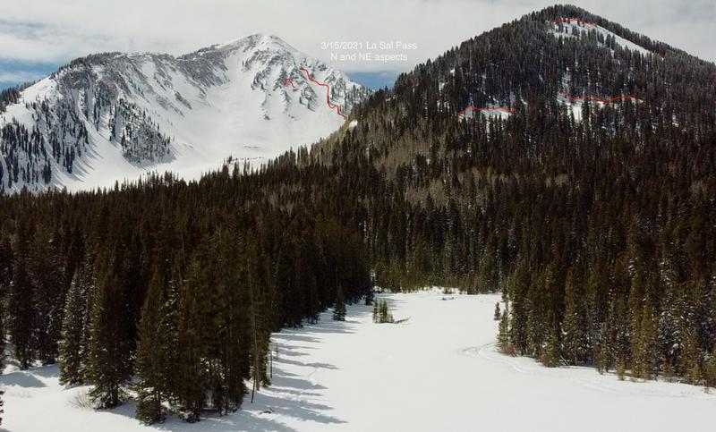
With yesterday's visibility and access to the high country (Thank you Grand County Road Department!!), reports continue to describe a widespread natural avalanche cycle from Sunday the 14th. Several large avalanches were observed Monday on northerly aspects in the La Sal Pass area that probably ran sometime on Sunday, the 14th. No avalanches were observed on southerly slopes in this area.
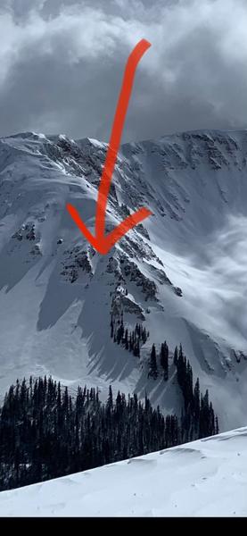
Reports of natural avalanches from the Gold Basin including this NE aspect above treeline were received yesterday.
Ad
Avalanche Problem #1
Persistent Weak Layer
Type
Location
Likelihood
Size
Description
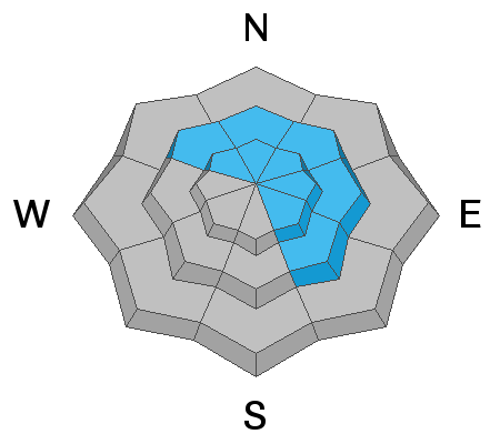
Several large avalanches on northerly aspects continue to be reported from Sunday the 14th. These most likely failed on weak snow near the ground. On similar slopes that have not avalanched, it is possible to trigger the same avalanche problem on slopes that face NW-NE-SE near and above treeline as these weak layers are still adjusting the weight of the recent snow. Reduce your exposure by keeping your slope angles below 30 degrees, especially if you experience cracking or collapsing. Your best bet is to seek shady, wind-sheltered-terrain that is clear of any overhead avalanche hazard, and not connected to any adjacent, steeper terrain.
Avalanche Problem #2
Wind Drifted Snow
Type
Location
Likelihood
Size
Description
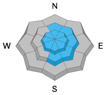
Strong NW winds on Sunday transported snow forming deep, unstable drifts near and above treeline on many aspects. These windslabs are becoming more difficult to trigger, however, it is still possible to trigger a large avalanche in places where the slab thins such as slope margins, and near rocky outcrops. Take time to investigate the snowpack for signs of windslabs including smooth, lens-like shapes, hollow-sounding snow, or even just relatively-denser snow and avoid these areas.
General Announcements
This forecast is from the U.S. Forest Service, which is solely responsible for its content. This forecast describes general avalanche conditions and local variations always occur.