Join us at our 2nd Annual Blizzard Ball

Forecast for the Moab Area Mountains

Dave Garcia
Issued by Dave Garcia on
Tuesday morning, February 7, 2023
The avalanche danger is LOW and generally stable snow conditions exist. By definition, small avalanches are possible in isolated areas or in extreme terrain.

The primary concerns are isolated pockets of wind-drifted snow on leeward slopes above treeline, and sluffing in the snow at the surface in steep northerly facing terrain. Evaluate each slope and look for any signs of instability such as cracking in fresh wind drifts or loose surface snow easily moving.

Risk is inherent in mountain travel; even a small avalanche can be problematic in very steep, consequential terrain.
Low
Moderate
Considerable
High
Extreme
Learn how to read the forecast here
Special Announcements
Geyser Pass Road: The road is plowed and widened with a snow packed surface.
Grooming: Trails were groomed on Monday. Thanks Matt!
Weather and Snow
24 Hour Snow 0" 72 Hour Snow 3" Season Total Snow 186" Base Depth at Gold Basin 73"
Winds on Pre Laurel Peak NE 10 G 20 Temp 4 F

Weather
Today will start out cold, and temperatures will top out around 20 degrees at 10,000 ft. We will have sunny skies and NE winds blowing 10-20 mph will keep things cool. The weather looks high and dry through the week, with long range models hinting at a return to a more active pattern mid-month.

General Conditions
Skiing and riding conditions remain quite good thanks to the three inches of snow that fell Sunday night. Solar aspects are dust on crust, but the shady slopes are holding up and offer soft, fun conditions. It helps that temperatures stayed cold on Monday and the sun was in and out of the clouds keeping the snow cold and light on the Northerlies. People have been taking advantage of the generally stable snow conditions and have been pushing up into high alpine terrain. Maggie Nielson and company took a trip to Corkscrew Glades on Monday and Sam Van Wetter was up high in Gold Basin over the weekend. Read their observations here.
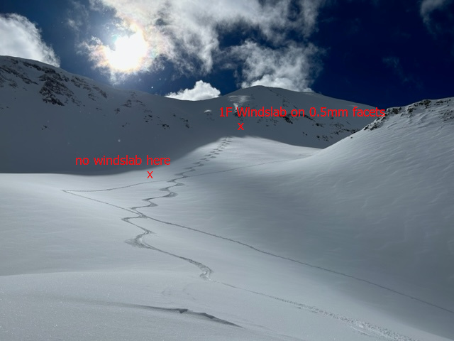
The snowpack is mostly stable, but I am still suspicious of lingering wind drifts on slopes that face North and East above treeline. In my travels yesterday I found some unstable drifts in isolated terrain features in the more extreme terrain. For more details, read my observations here. Older drifts have been covered by three inches of new snow, and may be harder to notice. Old hard drifts often produce hollow, drum-like sounds when you walk on them, and this is a good indication of trouble. If you are getting into big lines in the alpine, be on the lookout for hard slabs of wind drifted snow.
I encountered wind drifted snow in the steep gullies just below the ridgeline, a likely place to find trouble today.
While the likelihood of triggering an avalanche on the buried persistent weak layer that formed in November has become so low that we have removed that problem from our forecast, a remote possibility exists in thinner snowpack areas, or in very steep, rocky, radical terrain.
Always practice safe travel techniques regardless of conditions. Continue to evaluate the snowpack and gather as much information as possible. Use test slopes that are representative of the terrain you wish to ski.

Snowpack and Weather Data
Gold Basin Storm Stake (10,000')
Gold Basin SNOTEL site (10,000')
SNOTEL site near Geyser Pass Winter Trailhead (9600')
Wind Station on Pre-Laurel Peak (11,400')
NWS forecast for the La Sal Mountains.
Recent Avalanches
No new avalanches were reported in the backcountry. See the La Sal Avalanche database here.
Ad
Additional Information
General Announcements
This forecast is from the U.S.D.A. Forest Service, which is solely responsible for its content. This forecast describes general avalanche conditions and local variations always occur. This forecast will be updated by 7:30 tomorrow morning.