Forecast for the Moab Area Mountains

Eric Trenbeath
Issued by Eric Trenbeath for
Monday, February 27, 2023
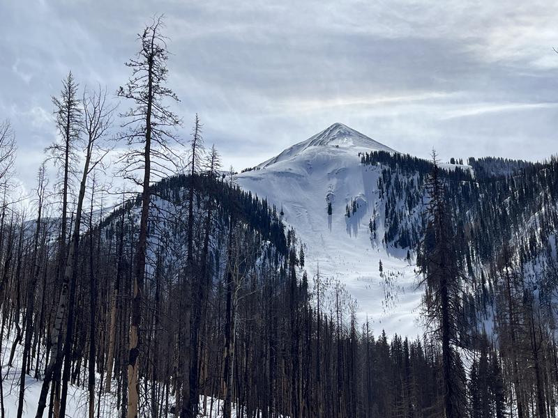
A MODERATE danger exists for human triggered avalanches involving slabs of wind drifted snow on slopes facing W-N-SE. The danger is most widespread on steep, northerly aspects where slabs 2'-4' deep may be resting on buried weak layers. Deep and dangerous, human triggered avalanches are possible in these areas.

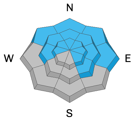
Out of the wind zone, most terrain on the south side of the compass has generally LOW danger.
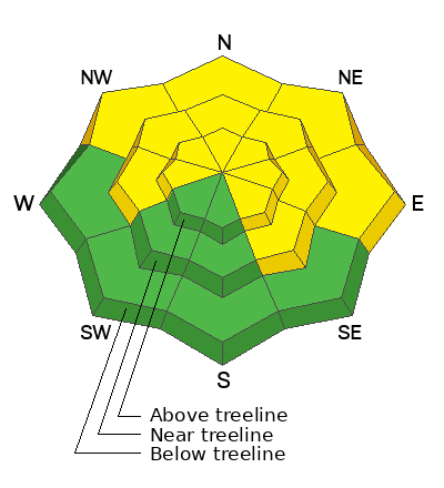
Low
Moderate
Considerable
High
Extreme
Learn how to read the forecast here
Special Announcements
Geyser Pass Road: Many cars made it up over the weekend and the drifting snow from Friday is mostly packed in. Fresh drifts are likely today. Plow crews may go up there later today after they clear the loop road and residential areas.
Grooming: Gavin and Matt teamed up Saturday to groom all trails. Expect a few inches of accumulated and drifted snow on them today.
Weather and Snow
6:00 a.m. Snow and Weather Data
24 Hour Snow ?" 72 Hour Snow ?" Season Total Snow 219" Base Depth at Gold Basin 80"
Winds on Pre Laurel Peak S 20-25 G30 Temp 26F

Weather
A broad trough of low pressure off the California coast will send a series of storms through the region this week on a west-southwest flow. The first wave passes by to the north today bringing us cloudy and windy conditions with a chance for an inch or two of snow tonight. SW winds blow in the 20-25 mph range with gusts to 40. High temps will be around 20F. SW winds will be on the increase tomorrow ahead of the next stronger wave with a chance for an inch or two of snow during the day. Snowfall increases Tuesday night with the period of highest snowfall occurring on Wednesday.

General Conditions
I'm having a hard time interpreting snow totals this morning with the Gold Basin storm stake showing 6" while the nearby SNOTEL site is reporting 0". 2" have fallen near the Geyser Pass Trailhead. I think it's safe to say there has been some blowing and drifting going on. Wind affect is the nature of the snow surface out there with breakable sun crusts on solar aspects. Soft snow can still be found in sheltered areas. Unstable slabs of wind drifted snow remain your primary concern. Deeper slabs formed earlier in the week will be harder to trigger. Fresh slabs will be shallow but could sweep you off your feet. In some areas, older slabs sit on a layer of weak, faceted snow, and these slabs may remain reactive for a longer period. Continuing to avoid steep, wind drifted, northerly facing terrain is the only sure way to avoid this problem.

Snowpack and Weather Data
Gold Basin Storm Stake (10,000')
Gold Basin SNOTEL site (10,000')
SNOTEL site near Geyser Pass Winter Trailhead (9600')
Wind Station on Pre-Laurel Peak (11,400')
NWS forecast for the La Sal Mountains.
Recent Avalanches
In our travels on Saturday, we observed a few avalanches that ran during peak storm intensity mid-week including Exxon's Folly, Gravel Pit Lanes, and the Lawnmower on the NE Face of Tukno. The Gravel Pit/Lawnmower avalanches were quite large as their starting zones are well situated for heavy wind loading.
Natural avalanche in Exxon's Folly.
See the La Sal Avalanche database here.
Ad
Avalanche Problem #1
Wind Drifted Snow
Type
Location
Likelihood
Size
Description
2' of snow and strong southerly winds last week created thick slabs of wind drifted snow, primarily on slopes facing NW-N-E-SE. Snow and wind yesterday formed shallow fresh slabs that could sweep you off your feet. On steep, wind drifted, northerly aspects human triggered avalanches 2'-4' deep are possible. Winds have mostly blasted S-W facing slopes, but isolated drifts may exist on the leeward sides of terrain features such as sub ridges, gully walls, and rock outcrops. Wind drifts are often recognizable by their smooth, rounded appearance, and cracking is a sign of instability. Avoid wind drifted slopes steeper than 30 degrees.
Avalanche Problem #2
Persistent Weak Layer
Type
Location
Likelihood
Size
Description
On some northerly aspects, wind drifted snow is sitting on top of buried weak layers. A layer of weak faceted snow formed on the surface early this month and it was covered by a foot of snow on Valentines day. It isn't widespread, and it hasn't proven to be very reactive in stability tests, but it's out there. On Saturday, I also observed a weak interface at the bottom of last week's storm snow. The few avalanches we observed Saturday likely failed on one of these weak layers. The bottom line is that with so much uncertainty, copious amounts of drifted snow, and more in the forecast, steep, northerly facing slopes are best avoided at this time.
Photo illustrates layers of concern.
Additional Information
Are you wondering how cell phones and other electronic devices can interfere with your avalanche transceiver? The "20/50 Rule" is that you want your beacon 20cm (8") away from other electronics while transmitting and 50cm (20") away from electronics while searching. Get the full scoop here.
General Announcements
This forecast is from the U.S.D.A. Forest Service, which is solely responsible for its content. This forecast describes general avalanche conditions and local variations always occur. This forecast will be updated by 7:30 tomorrow morning.