Join us at our 2nd Annual Blizzard Ball

Forecast for the Moab Area Mountains

Eric Trenbeath
Issued by Eric Trenbeath on
Saturday morning, February 27, 2021
The avalanche danger remains a solid MODERATE although a few inches of new snow with wind has slightly elevated the danger. Look for sensitive fresh drifts on the leeward sides of ridge crests and terrain features on all aspects, primarily at upper elevations. Of greater concern is the very real possibility of triggering deep and dangerous avalanches failing on a buried persistent weak layer. You are most likely to trigger one of these avalanches on steep terrain facing NW-N-SE. The danger increases with elevation where wind drifted snow has added stress to buried persistent weak layers. Thinner snowpack areas near rock outcroppings, sparse trees, or along slope margins are the most likely areas to trigger an avalanche. Most S-SW facing terrain near treeline and below has LOW danger.
Low
Moderate
Considerable
High
Extreme
Learn how to read the forecast here
Special Announcements
The Geyser Pass Road is plowed but the surface is snow-packed, icy, and slick. All-wheel drive with good tires is recommended.
The Lower Utah Nordic Alliance (LUNA) groomed and set classic track into Gold Basin yesterday but a few inches of snow has fallen overnight.
Weather and Snow
24 Hour Snow 4" 72 Hour Snow 4" Base Depth in Gold Basin 50" Wind WNW 10-15 Temp 9 F
A pulse of energy from the passing storm delivered what appears to be 2"-4" of new snow early this morning. SW winds ahead of the storm picked up yesterday evening and blew for a few hours in the 20-25 mph range with gusts into the high 30's and low 40's. They backed off around midnight shifting to more westerly. Look for clearing skies later today with light to moderate NW winds. High temps will be in the low teens. Tonight temps will plummet to near 0F. Sunday looks to be sunny and only slightly warmer but with a chilly NE wind. Conditions look dry into mid-week and likely beyond. Models are still undecided about a potential system around Thursday. The long-range crystal ball shows a stormy pattern emerging around mid-month.
Wind, temperature, humidity on Pre Laurel Peak (11,700')
Snotel site near Geyser Pass Trailhead (9600')
Storm totals at the Gold Basin study plot (10,000')
Snowpack Discussion
A few inches of new snow will provide a bit of a refresh to the snow surface. This isn't likely to change the avalanche danger much but there may be a few sensitive, shallow wind drifts at upper elevations. Warmer temperatures and time have helped consolidate the snowpack, but weak layers of sugary, faceted snow still exist on most aspects. Outward signs of instability are far and few between but on Wednesday, Chris Benson still experienced localized whumpfing on a ridgeline where the snowpack was thinner and weaker. On slopes facing NW-N-SE a slab 1'-3' thick exists on top of buried, weak, facets. These slabs are becoming harder to trigger but once released they would produce deep and dangerous avalanches. Likely trigger points include shallower areas along slope margins, around sparse trees or rock outcroppings, or on repeat running slide paths. It's a gamble out there right now, and it's not a chance any of the forecasters or observers I know are willing to take.
Chris Benson sums up conditions in the video below:
Recent Avalanches
Ad
Avalanche Problem #1
Persistent Weak Layer
Type
Location
Likelihood
Size
Description
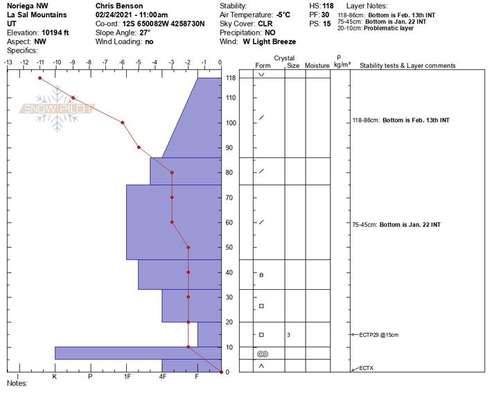
Poor snowpack structure still exists with buried persistent weak layers of loose, sugary, faceted snow on most aspects. The most dangerous areas are on slopes above treeline that face NW-NE-SE where wind drifted snow has created slabs 1'-3' deep on top of these buried weak layers. Once triggered, these slab avalanches would be large and unsurvivable. The snowpit below submited by Chris Benson illustrates the problem. Picture building blocks stacked on top of one another with varying strengths and thicknesses, and note the very precarious situation between 10-20 cms. This is the layer of weak, sugary snow that the rest of the snowpack is sitting on.
Avalanche Problem #2
Wind Drifted Snow
Type
Location
Likelihood
Size
Description
We may see some areas with unstable fresh deposits of wind drifted snow out there today. Look for fresh shallow drifts on the leeward sides of ridge crests and terrain features in upper elevation, wind exposed terrain.
Additional Information
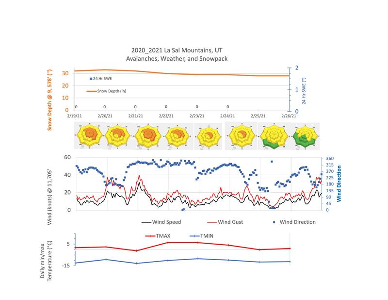
Here is last week's weather data compiled by Chris Benson.
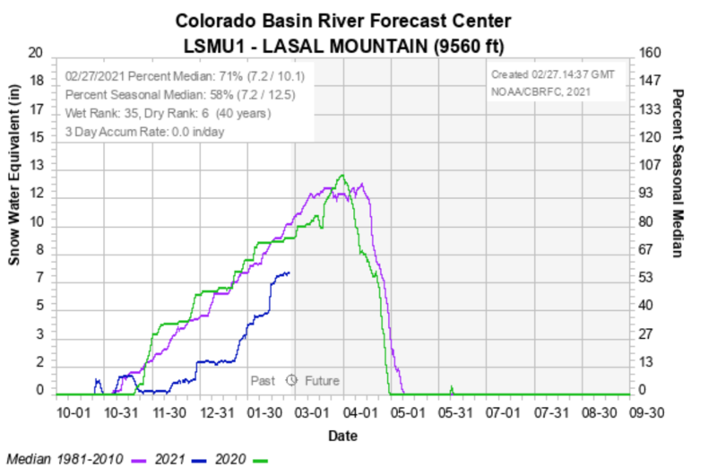
And here are some snowpack data from the Colorado River Basin Forecast Center. We are currently at 71% of normal.
General Announcements
This forecast is from the U.S. Forest Service, which is solely responsible for its content. This forecast describes general avalanche conditions and local variations always occur.