Forecast for the Moab Area Mountains

Eric Trenbeath
Issued by Eric Trenbeath for
Friday, November 30, 2018
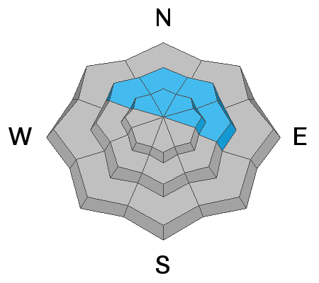
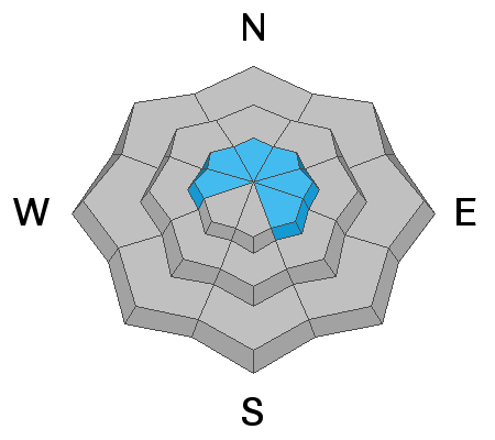
The avalanche danger is CONSIDERABLE in upper elevation wind exposed terrain that faces NW-N-E and human triggered avalanches up to 2' deep are likely. There is a MODERATE danger on similar aspects at mid elevations. Below about 10,000' the avalanche danger is generally LOW.
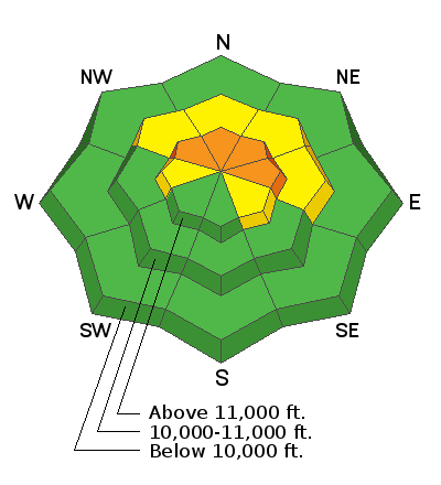
Low
Moderate
Considerable
High
Extreme
Learn how to read the forecast here
Weather and Snow
Well it certainly isn't a whopper but we'll take what we can get. Snowfall started around 1:00 a.m. and we've picked up about 4" at 10,000' with likely around 6" up high. Snow should continue through the morning with 2-4" possible. SW winds wailed yesterday in the 25 to 45 mph range but backed off when the snow started to fall. They are currently averaging 15 mph along ridge tops, gusting to 25 mph. Snowfall should continue through the morning and taper off by around noon. Winds will shift to the WNW with gusting to 30 mph. High temps at 10,000' will be around 20 degrees.
The existing base varied from 18"-30" above 10,000' on NW-N-E aspects. Due south facing slopes were mostly bare ground, but some snow remained on SE and westerly facing slopes. The added new snow is not enough to turn on the green light for winter recreation. For today it may actually make things worse by barely covering up rocks and deadfall that was previously exposed. But we're in this for the long haul and every little but helps. Total depth in Gold Basin is 20". I'd say we need at least another foot before we're ready to go.
New snow totals in Gold Basin (10,000')
Snow totals at the Geyser Pass Trailhead (9600')
Wind, temperature, and humidity on Pre Laurel Peak (11,700')
National Weather Service point forecast.
Ad
Avalanche Problem #1
Persistent Weak Layer
Type
Location
Likelihood
Size
Description
Our biggest concern today will be triggering an avalanche up to 2' deep that breaks down into older weak snow. Above 10,000' 18-24" of snow has been sitting on the ground on northerly aspects since mid-October. This snow has been been deteriorating into weak, sugary, faceted snow near the ground, and at different levels in the snowpack. In some areas, the entire snowpack is made up of loose, weak, faceted snow. This makes an unstable base for the current and future snow loads.
Avalanche Problem #2
Wind Drifted Snow
Type
Location
Likelihood
Size
Description
Blowing and drifting snow will form shallow wind slabs along the leeward sides of ridge crests and terrain features in upper elevation, wind exposed terrain. In and of themselves, these shallow drifts shouldn't be too problematic, but a triggered wind slab will likely step down into old, weak, faceted snow resulting in a deeper and more dangerous avalanche. Avoid steep slopes that have recent deposits of wind drifted snow or that have a smooth rounded appearance to them.
General Announcements
We are very proud to introduce our new website for the 2018-19 winter season. This will provide an easier and cleaner way to view all of the snow and avalanche information that you've come to rely on. We are quite happy with how the new website performs on mobile devices as well. We think you'll find the desktop or laptop experience pleasant as well. We are still tying up some loose ends so bear with us.