Fall Auction is now live! Check it out now

Forecast for the Moab Area Mountains

Eric Trenbeath
Issued by Eric Trenbeath on
Saturday morning, January 8, 2022
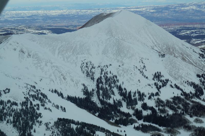
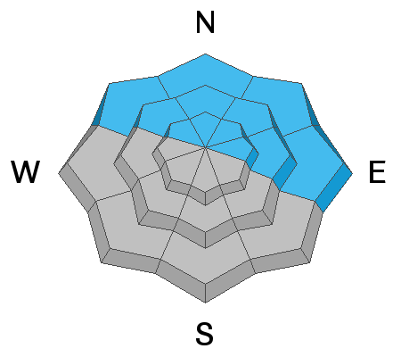
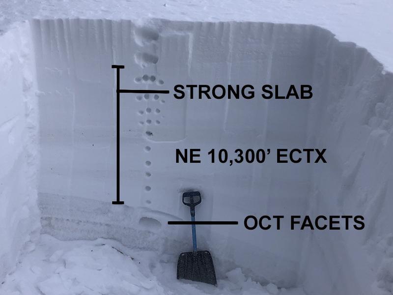
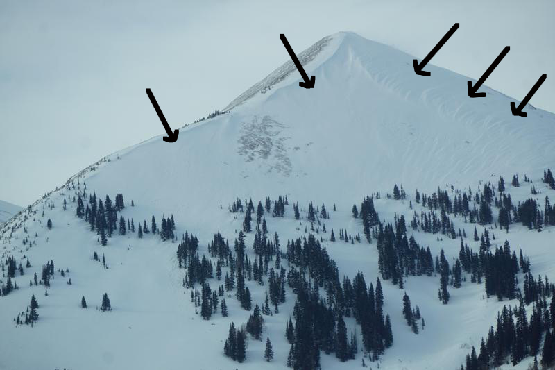
The avalanche danger is MODERATE on all steep, north facing slopes where triggering a large, deep, and very dangerous avalanche failing on a buried persistent weak layer remains possible. The danger increases with elevation and wind loaded slopes are more suspect.
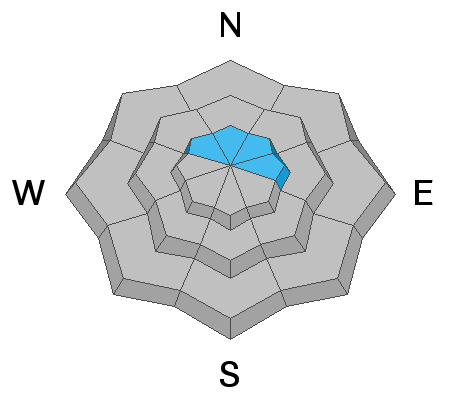
An isolated or MODERATE avalanche danger also exists for smaller avalanches involving recent deposits of wind drifted snow. Recent wind slabs have formed primarily on slopes facing the north side of the compass but they may be found on all aspects above treeline.
Though the likelihood of triggering a deep and dangerous avalanche is trending downward, an avalanche of this magnitude would be un-survivable. Careful terrain choices and avoidance of steep, northerly facing terrain is the only guaranteed strategy.
Low
Moderate
Considerable
High
Extreme
Learn how to read the forecast here
Special Announcements
Road Conditions: The dirt road to Geyser Pass Trailhead is plowed, but snow packed and slick. AWD and good tires recommended.
Grooming: After working all week to dig out, cut trees and pack trails, LUNA volunteers groomed yesterday!
Weather and Snow
24 Hour Snow 0" 72 Hour Snow 0" Base Depth in Gold Basin 45" Wind SW 15-20 Temp 28
Gold Basin SNOTEL site (10,000')
Storm Totals in Gold Basin
Wind Station on Pre Laurel Peak (11,700')
NWS Weather Forecast
A storm system to the north has brought clouds into our area this morning. As the cold front tracks through to the SE we could see an inch or two of snow by afternoon. Otherwise, we'll see mostly cloudy skies, breezy, SW winds shifting to the NW, and daytime highs in the mid 20's. High pressure builds into the week.
Snowpack
It's been a week since last Friday's storm event which produced dozens of deep, hard slab avalanches failing on a persistent weak layer of sugary, faceted snow at the base of the snow pack. The heavy load provided a significant test for slopes that didn't avalanche, and time and warmer temperatures have aided in the healing process. Stability tests performed by myself and local observers this week indicate that an avalanche of this size would be harder to trigger now but if you did find the right spot, the result would be devastating. Likely trigger points include shallow, rocky areas, lines along slope margins, or steep convexities. With avalanches of this magnitude remaining a real possibility, careful terrain choices remain imperative and in the final analysis, venturing on to steep, north facing terrain is still a little bit like walking through a mine field.
Wind, sun, and warm temperatures have affected the snow surface in exposed areas but fortunately we escaped the rain experienced by our northern neighbors. Charlie Ramser was up Thursday, and he was still able to find soft, settled powder in sheltered areas. He also noted a strengthening snowpack but with a developing layer of near surface facets beneath a wind crust. Read his observation here. And for some great aerial photos of the range and how it was affected by the wind this week, check out this observation from Chris Benson.
Aerial view of Mount Peale from the south. Chris Benson photo.
Recent Avalanches
No new avalanches have been reported since last Friday's impressive avalanche cycle. Go here for the complete list.
Ad
Avalanche Problem #1
Persistent Weak Layer
Type
Location
Likelihood
Size
Description
It's been a week since last Friday's storm event which produced dozens of deep, hard slab avalanches failing on a persistent weak layer of of sugary, faceted snow at the base of the snow pack. The heavy load provided a significant test for slopes that didn't avalanche, and time and warmer temperatures have aided in the healing process. Stability tests performed by myself and local observers this week indicate that an avalanche of this size would be harder to trigger now but if you did find the right spot, the result would be devastating. Likely trigger points include shallow, rocky areas, lines along slope margins, or steep convexities. With avalanches of this magnitude remaining a real possibility, careful terrain choices remain imperative and in the final analysis, venturing on to steep, north facing terrain is still a little bit like walking through a mine field.
Photo illustrates strong slab over weak, October facets. Extended column tests produced no results and it's becoming harder for the weight of a skier or rider to affect this basal weak layer. Propagation saw tests however show that it is still possible for a slab to fail and propagate. Shallower snowpack areas are likely trigger points.
Avalanche Problem #2
Wind Drifted Snow
Type
Location
Likelihood
Size
Description
You may still be able to find some isolated slabs of wind drifted snow out there in the high country. Potentially unstable drifts are most likely to be found on northerly aspects but they may also exist on slopes with a west or southeasterly tilt. In some cases they may be found adjacent to bare slopes where a subtle terrain feature such as a sub-ridge or gully wall has caused deposition on the leeward side. Wind slabs are recognizable by their smooth, rounded appearance, or hollow sound and feel. Cracking is a sign of instability. On northerly aspects, wind drifted snow has added stress to older slabs on top of a buried persistent weak layer and dangerous, human triggered avalanches 3'-5' deep are possible. Continue to avoid steep, wind drifted slopes.
Areas of a wind drifted snow on a northerly aspect from south and westerly winds. Note the rippled effect indicating recent drifting as well as overhanging cornices indicating wind direction and loading areas on leeward aspects. Chris Benson photo.
General Announcements
Who's up for some free avalanche training? Get a refresher, become better prepared for an upcoming avalanche class, or just boost your skills. Go to https://learn.kbyg.org/ and scroll down to Step 2 for a series of interactive online avalanche courses produced by the UAC.
This forecast is from the U.S. Forest Service, which is solely responsible for its content. This forecast describes general avalanche conditions and local variations always occur.