Forecast for the Moab Area Mountains

Eric Trenbeath
Issued by Eric Trenbeath for
Sunday, January 28, 2024
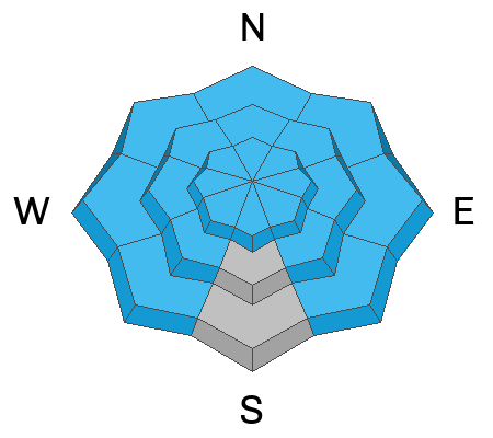
A CONSIDERABLE avalanche danger remains on steep slopes near and above treeline that face W-N-E-SE. Human triggered avalanches failing on a buried persistent weak layer 2'-6' deep are likely.
A MODERATE avalanche danger exists on all aspects below treeline, and on steep slopes facing SW-S at all elevations. Human-triggered avalanches failing on a buried persistent weak layer are possible.

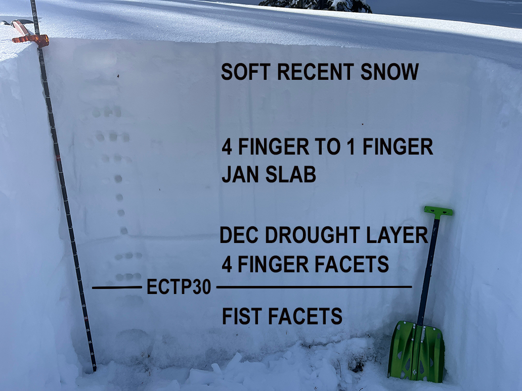
As outward signs of instability decrease, it's important to remember what lies underneath. Continue to avoid slopes steeper than 30 degrees, especially those that face W-N-E-SE.
Low
Moderate
Considerable
High
Extreme
Learn how to read the forecast here
Special Announcements
Road Conditions: The Geyser Pass road has not been plowed since 4" of new snow fell on Wednesday. Many vehicles have made it up, but AWD with good tires are required.
Grooming: Matt and Ben groomed all trails and set classic track on Friday.
Our avalanche beacon checker sign and beacon training park are up and running. A huge thanks to Talking Mountain Yurts for sponsoring those this season!
Weather and Snow
6:00 a.m. Snow and Weather Data
24 Hour Snow 0" 72 Hour Snow 4" Season Total Snow 95" Base Depth at Gold Basin 42"
Winds on Pre-Laurel Peak: NW 5-10 Temp 24˚ F

Weather
A ridge of high pressure is parked over the West bringing sunny skies and warmer than average temperatures to the region. High temperatures over the next several days will be near 40F at 10,000'. Overnight lows will be in the lower 20's and winds will be generally light from the NW. A powerful looking storm system is shaping up for later next week but a lot can happen between now and then. Keep your fingers crossed for a snowy beginning of February!
General Conditions
It will be a beautiful day in the mountains. Soft settled powder over a now mostly supportable base can still be found today on shady aspects. Sun and warm temperatures have crusted over most south facing slopes. A strong slab is developing over the weak faceted snow underneath and in our travels on Friday, Dave and I did not experience any collapsing of the snowpack for the first time in two weeks. I did receive two reports yesterday of collapsing in very thin snowpack areas below 10,000'. Although most of our riding terrain is above this elevation, this is a stark reminder of the weak foundation. We are entering a tricky phase. Thinner snowpack areas remain highly problematic, while deeper areas remain highly suspect. Dangerous avalanches remain possible to likely and avoidance of slopes steeper than 30 degrees that face W-N-E-SE continues to be the strategy.
Snowpack and Weather Data
Gold Basin Storm Stake (10,000')
Gold Basin SNOTEL site (10,000')
SNOTEL site near Geyser Pass Winter Trailhead (9600')
Wind Station on Pre-Laurel Peak (11,400')
NWS forecast for the La Sal Mountains.
Ad
Avalanche Problem #1
Persistent Weak Layer
Type
Location
Likelihood
Size
Description
A persistent weak layer of faceted snow exists about 2 feet below the snow surface. Over the past two weeks it has produced widespread collapsing, a few natural avalanches, and continuously reactive stability tests. In our travels on Friday, Dave and I observed the first signs that this weak layer is gaining strength in some areas. This does not mean we are out of the woods. On the contrary, it means that things are about to get more tricky. When outward signs of instability such as collapsing and whumphing are in our face, the danger is obvious. When they aren't present, it can give us a false sense of security. As far as faceted weak layers are concerned, they take a long time to heal. Areas where you are most likely to trigger a deep and dangerous avalanche are on slopes steeper than 30 degrees that face W-N-E-SE.
This profile is from a NE facing slope at 11,250'. The top few inches are soft snow that fell over the past week. The 4 finger to 1 finger slab is the rest of the snow that fell in January. The December drought layer is becoming more dense, and did not produce a failure. The 4 finger facet layer beneath is also gaining strength. The weakest snow remains near the ground where fist density facets can be found. An extended column test produced results of ECTP 30 at the top of this layer. What this tells us is that in deeper snowpack areas, it is becoming harder for the weight of a person to affect buried weak layers, but if they did, the avalanche would be deep and nearly to the ground. In shallower snowpack areas, it is easier to affect this buried weak layer, and human triggered avalanches are much more likely.
Additional Information
Want some more insight into the La Sal Mountains as well as the communal impacts of a tragic avalanche? Check out the latest UAC podcast with forecaster Eric Trenbeath where he discusses the range, it's often treacherous snowpack, and how the devastating avalanche in February, 1992, affected the Moab community.
Sign up for forecast region-specific text message alerts. You will receive messages about changing avalanche conditions, watches, warnings and road plowing closures.
Follow us on Instagram @utavy_moab
General Announcements
This forecast is from the U.S.D.A. Forest Service, which is solely responsible for its content. This forecast describes general avalanche conditions and local variations always occur.