UDOT PLANNED AVALANCHE CLOSURES!!

Forecast for the Moab Area Mountains

Eric Trenbeath
Issued by Eric Trenbeath for
Friday, January 25, 2019
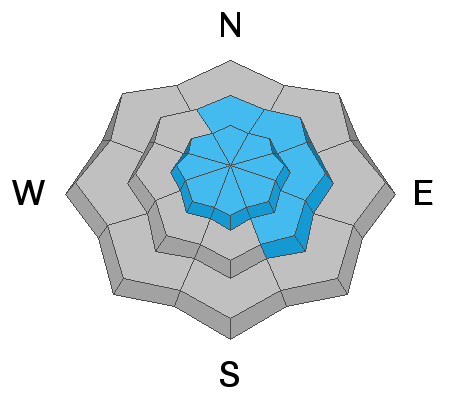
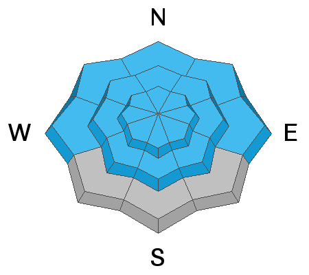
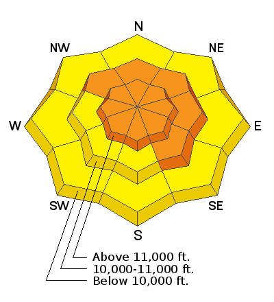
The avalanche danger remains CONSIDERABLE and human triggered avalanches are likely on any steep, wind drifted slope. The problem is most widespread on steep, upper elevation slopes that face NW-N-E, but you need to be alert to possible wind drifts on all aspects. In addition to problems within the most recent snow, deep and dangerous avalanches failing on a buried persistent weak layer are also likely. This problem also exists primarily on steep slopes facing NW-N-E, but there is also a possibility for triggering this type of avalanche on west and south facing terrain. Conservative terrain choices remain essential. Stick to low angle, wind sheltered terrain and meadows. On low elevation, and most south facing terrain, the danger is MODERATE.
Low
Moderate
Considerable
High
Extreme
Learn how to read the forecast here
Special Announcements
We will be offering a Backcountry 101 avalanche course on Feb 8, 9. It's a great way to up your avalanche knowledge with both classroom, and hands on field instruction. Click here for more details and to register. Much thanks to Moab Gear Trader for sponsoring this course! Please visit them for all of your winter backcountry needs.
Weather and Snow
Skies are mostly clear and 10,000' temps are around 10 degrees. NW winds ramped up a bit last night averaging 20 mph with gusts into the 30's and 40's. Around 6:00 a.m. they backed off into the 15-25 mph range. Today look for increasing clouds as a weak storm system clips by to the north. High temps will be in the low 20's, and NW winds will blow 15-20 mph along ridge tops. The weekend looks beautiful with sunny skies and warming temperatures. There are no storms for the foreseeable future.
Winds have worked over the high country, but reports of excellent conditions in sheltered terrain continue to come in. Chris Jacobsen and company were over on the east side of the range yesterday, tearing up fluffy powder snow on low angle, wind sheltered terrain.
Chris Jacobsen photo. Rider: Greg Kosa
Base depth in Gold Basin: 60"
New snow totals in Gold Basin (10,000')
Snow totals at the Geyser Pass Trailhead (9600')
Wind, temperature, and humidity on Pre Laurel Peak (11,700')
National Weather Service point forecast.
Recent Avalanches
Monday's storm brought another round of avalanche activity, though not as widespread as I would have expected. For the most part, avalanches failing on a persistent weak layer appear to have happened on slopes that haven't run yet, and the range seems to be coming a part piece by piece. One notable exception was a reported repeat running slide in Lone Pine.
Chris Jacobsen sent in this photo of an avalanche on the NE face of Peale that likely occurred on Monday. This is the type of deep and dangerous avalanche you definitely don't want to be involved with. Human triggered avalanches of this magnitude are still likely in this kind of terrain. Note the wind scoured surface in the foreground.
This photo I took of Noriega's Face on Wednesday illustrates the piecemeal avalanche activity of the past several weeks. Exxon's Folly has come apart in similar fashion. The take home for me is that deep and dangerous avalanches are still possible on slopes that haven't run yet. For more on recent avalanches see Dave Garcia's report.
Ad
Avalanche Problem #1
Wind Drifted Snow
Type
Location
Likelihood
Size
Description
Winds continue to blow and drift snow in the high country. Today you'll have to contend with both shallow, recent deposits, and deeper, older drifts that formed earlier in the week. Wind slabs will be stiff, and maybe a bit stubborn today, but when they break, they could fail 2' deep or more. Due to the intensity of the winds, and high quantity of snow available for transport, drifting has occurred on all aspects. Avoid any steep slope that shows signs of recent wind loading. Expect to find recent drifts on the lee sides of ridge crests and terrain features such as gully walls, sub-ridges, and rock outcroppings. Fresh drifts are recognizable by their smooth rounded, pillowy appearance, and cracking in the snow surface is a sign of an unstable drift or wind slab.
Areas of wind drifted snow cover the high country. Note all the smooth, "pillowy" rounded deposits. Avoid steep wind drifted terrain such as this. Dave Garcia photo.
Avalanche Problem #2
Persistent Weak Layer
Type
Location
Likelihood
Size
Description
The snowpack is beginning to adjust to the new load, and it's getting deep enough that we should start to see some strengthening. Nevertheless, it's going to take some time before we can quit worrying about buried, persistent weak layers. The primary concern is a layer of weak, sugary, faceted snow that formed in mid December. Since Christmas Eve, regular storms have now piled more than 3' of snow on top of this layer. Add wind drifting, and we've seen avalanches up to 7' deep. The danger is greatest on steep slopes facing the north half of the compass, but I've found weak snow, and experienced collapsing on all aspects. The only good strategy for now is to continue to avoid steep terrain.
This video was shot last weekend, but it still describes the current state of the snowpack.
Additional Information
Grooming: Volunteers from LUNA have been busy all week packing down the new snow, and yesterday they completed grooming the entire mountain from Gold Basin through Geyser Pass.
General Announcements
Your information can save lives. If you see anything we should know about, please help us out by submitting snow and avalanche observations HERE. You can also call me at 801-647-8896, or send me an email: [email protected].
Support the UAC through your daily shopping. When you shop at Smith's, or online at REI, Backcountry.com, Patagonia, NRS, Amazon, eBay by clicking on these links, they donate a portion of your purchase to the UAC. If you sell on eBay, you can have your See our Affiliate Page for more details on how you can support the UAC when you shop
This advisory is from the U.S.D.A. Forest Service, which is solely responsible for its content. This advisory describes general avalanche conditions and local variations always occur.