UDOT PLANNED AVALANCHE CLOSURES!!

Forecast for the Moab Area Mountains

Eric Trenbeath
Issued by Eric Trenbeath for
Thursday, January 24, 2019
The avalanche danger is CONSIDERABLE and human triggered avalanches are likely on any steep, wind drifted slope. The problem is most widespread on steep, upper elevation slopes that face W-N-E, but you need to be alert to possible wind drifts on all aspects. In addition to problems within the most recent snow, deep and dangerous avalanches failing on a buried persistent weak layer are also likely. This problem also exists primarily on steep slopes facing W-N-E, but the possibility also exists for triggering this type of avalanche on south facing terrain. Conservative terrain choices remain essential. Stick to low angle, wind sheltered terrain and meadows.
Low
Moderate
Considerable
High
Extreme
Learn how to read the forecast here
Special Announcements
We will be offering a Backcountry 101 avalanche course on Feb 8, 9. It's a great way to up your avalanche knowledge with both classroom, and hands on field instruction. Click here for more details and to register. Much thanks to Moab Gear Trader for sponsoring this course! Please visit them for all of your winter backcountry needs.
Weather and Snow
A few clouds are hanging over the mountains, but we should see clearing skies and a bright, sunny day by mid morning. WNW winds are blowing the same that they have been for the last 24 hours, averaging 15-20 mph along ridge tops with occasional gusts to 30 mph. They'll continue to blow like that today. 10,000' temps are in the mid teens and won't get much higher today.
Conditions yesterday were nothing short of primo in wind sheltered terrain. 16" of low density snow fell on Monday night, and deep powder can still be found below tree line on sheltered slopes and meadows. Strong NW winds during the storm moved lots of snow around, and the higher alpine terrain is a mix of deep wind drifts and scoured surfaces, neither of which hold appeal. Keep it low and sheltered for both safe, and quality.
I received a couple good observations from yesterday including this one from Dave Garcia, and another from a visitor I chatted with at the Trans La Sal trailhead. He reported lot's of collapsing on his way to Noriega's West Glade, as well as a recent avalanche in the Corkscrew Glades.
Base depth in Gold Basin: 60"
New snow totals in Gold Basin (10,000')
Snow totals at the Geyser Pass Trailhead (9600')
Wind, temperature, and humidity on Pre Laurel Peak (11,700')
National Weather Service point forecast.
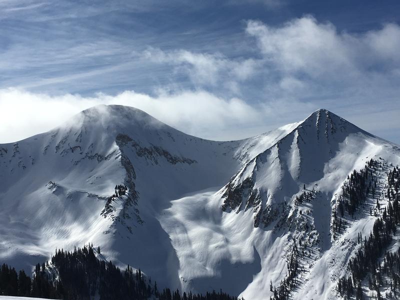
Lots of wind drifted terrain in the high country. You're going to want to continue to stay out of places that look like this. Dave Garcia photo.
Recent Avalanches
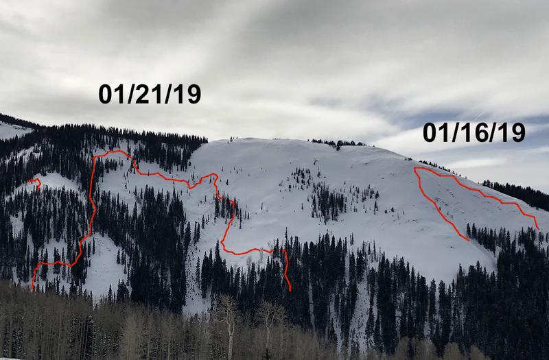
Monday's storm brought another round of avalanche activity, though not as widespread as I would have expected. For the most part, avalanches failing on a persistent weak layer appear to have happened on slopes that haven't run yet, and the range seems to be coming a part piece by piece. One notable exception was a reported repeat running slide in Lone Pine.
This photo I took of Noriega's Face yesterday illustrates the piecemeal avalanche activity of the past several weeks. Exxon's Folly has come apart in similar fashion. The take home for me is that deep and dangerous avalanches are still possible on slopes that haven't run yet. For more on recent avalanches see Dave Garcia's report.
Ad
Avalanche Problem #1
Wind Drifted Snow
Type
Location
Likelihood
Size
Description
Heavy snowfall, combined with strong winds, have created widespread areas of unstable, wind drifted snow in exposed terrain. Wind slabs will be stiff, and maybe a bit stubborn today, but when they break, they could fail 2' deep or more. Due to the intensity of the winds, and high quantity of snow available for transport, drifting has occurred on all aspects. Avoid any steep slope that shows signs of recent wind loading. Expect to find recent drifts on the lee sides of ridge crests and terrain features such as gully walls, sub-ridges, and rock outcroppings. Fresh drifts are recognizable by their smooth rounded, pillowy appearance, and cracking in the snow surface is a sign of an unstable drift or wind slab.
Avalanche Problem #2
Persistent Weak Layer
Type
Location
Likelihood
Size
Description
New and wind drifted snow continues to dangerously overload buried persistent weak layers in the snowpack. Last week saw a fairly widespread cycle with avalanches failing 2'-4' deep on average, with at least one slope breaking up to 7' deep. This week saw more avalanches failing on a persistent weak layer. Though it has primarily been a problem on northerly facing slopes, weak, sugary layers are present on all sides of the compass, and we are now getting enough of a load to stress them. Bottom line is that today is a good day to dial back your slope angle on all aspects.
General Announcements
Your information can save lives. If you see anything we should know about, please help us out by submitting snow and avalanche observations HERE. You can also call me at 801-647-8896, or send me an email: [email protected].
Support the UAC through your daily shopping. When you shop at Smith's, or online at REI, Backcountry.com, Patagonia, NRS, Amazon, eBay by clicking on these links, they donate a portion of your purchase to the UAC. If you sell on eBay, you can have your See our Affiliate Page for more details on how you can support the UAC when you shop
This advisory is from the U.S.D.A. Forest Service, which is solely responsible for its content. This advisory describes general avalanche conditions and local variations always occur.