Forecast for the Moab Area Mountains

Eric Trenbeath
Issued by Eric Trenbeath for
Friday, January 20, 2023
A MODERATE danger exists for human triggered avalanches involving unstable slabs of wind drifted snow on all aspects above treeline, and on slopes facing W-N-E near treeline.

A low probability/high consequence scenario remains for dangerous avalanches failing on a buried persistent weak layer. Avoid steep, wind drifted slopes and areas of rocky, extreme terrain that have primarily a northerly aspect.
Low
Moderate
Considerable
High
Extreme
Learn how to read the forecast here
Special Announcements
Road Conditions: Grand County was up again plowing the road yesterday. It is now very narrow with deep banks on the sides and a soft surface underneath. AWD with good tires required. Use caution and beware of oncoming vehicles.
Grooming: All trails were groomed with the snowcat on Wednesday, and Matt was up yesterday fine tuning and setting classic track into Gold Basin.
Weather and Snow
24 Hour Snow 0" 72 Hour Snow 13" Season Total Snow 169" Base Depth at Gold Basin 81"
Winds on Pre Laurel Peak ESE 15-25 G35 Temp 16

Weather
A fast moving and weakening closed low system will track eastward through northern AZ today bringing a small shot of snow to the La Sal and Abajo mountains. 2"-4" seem likely. SE winds will blow in the 15-20 mph range along ridge tops gradually swinging more easterly and finally shifting to the north on Saturday. We should see some clearing skies on Saturday before the next closed low system arrives late Sunday.
General Conditions
It's been another great run of snowfall this week with nearly 3' of snow and 3.6" of Snow Water Equivalent (SWE) since Sunday. The new snow is settling out rapidly but conditions remain excellent. SE winds whipped up over night and have been blowing the recent snow into fresh drifts. Today, expect to find unstable slabs of wind drifted snow sensitive to the weight of a skier or rider on leeward slopes in wind affected terrain.
The November persistent weak layer (PWL) has just been given a significant load test and in our travels yesterday we found an area where it failed producing a large, long running, un-survivable avalanche. The odds of triggering this kind of avalanche with the weight of a skier or rider are growing increasingly unlikely, however it still may be possible in outlying areas that have a combination of radical terrain and a thinner, weaker snowpack.
For more snowpack information see a complete list of observations here.

Snowpack and Weather Data
Gold Basin Storm Stake (10,000')
Gold Basin SNOTEL site (10,000')
SNOTEL site near Geyser Pass Winter Trailhead (9600')
Wind Station on Pre-Laurel Peak (11,400')
NWS forecast for the La Sal Mountains.
Recent Avalanches
In our travels yesterday we encountered a large avalanche (detailed in the video above) that failed on the November persistent weak layer sometime during this week's storm cycle.
This avalanche occurred on a steep northerly aspect near treeline in an area that has a thinner, weaker underlying snowpack. The starting zone is susceptible to heavy windloading and the terrain is fairly extreme with a steep convexity at the fracture line.
For a complete list of avalanches see the La Sal Avalanche database here.
Ad
Avalanche Problem #1
Wind Drifted Snow
Type
Location
Likelihood
Size
Description
Overnight SE winds have blown and drifted the most recent snow creating unstable slabs on the leeward sides of ridge crests and terrain features in wind exposed terrain. Look for fresh drifts on all aspects above treeline, and on slopes that face W-N-E below. Older drifts that formed mid-week will be covered up now, and though they have mostly stabilized, steep slopes that have a smooth, rounded, "fat" appearance should be approached with caution, especially on slopes with steep convexities. In very isolated, thinner snowpack areas, an avalanche triggered in the wind drifted snow could to step down to the November PWL.
Avalanche Problem #2
Persistent Weak Layer
Type
Location
Likelihood
Size
Description
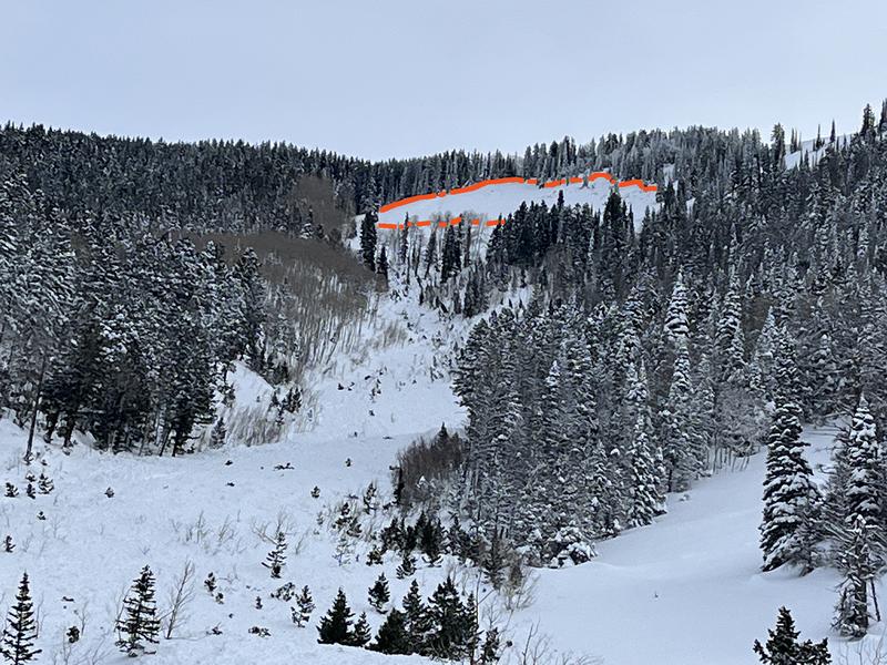
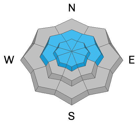
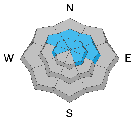
If you've been following along, you know that The November persistent weak layer (PWL) has been gaining strength and is deeply buried in most areas. Prior to this storm event, the last round of avalanches failing on this weak layer was during the New Years storm cycle. Before putting this problem to bed so to speak, we wanted to see what this latest load of heavy snowfall would do, and lo and behold, it produced a very large avalanche. Avalanche activity was not widepsread, and stability tests indicate that the odds of a skier or rider triggering this kind of avalanche are unlikely, however it still may be possible in outlying areas that have a combination of radical terrain and a thinner, weaker snowpack, particularly on slopes facing the north side of the compass.
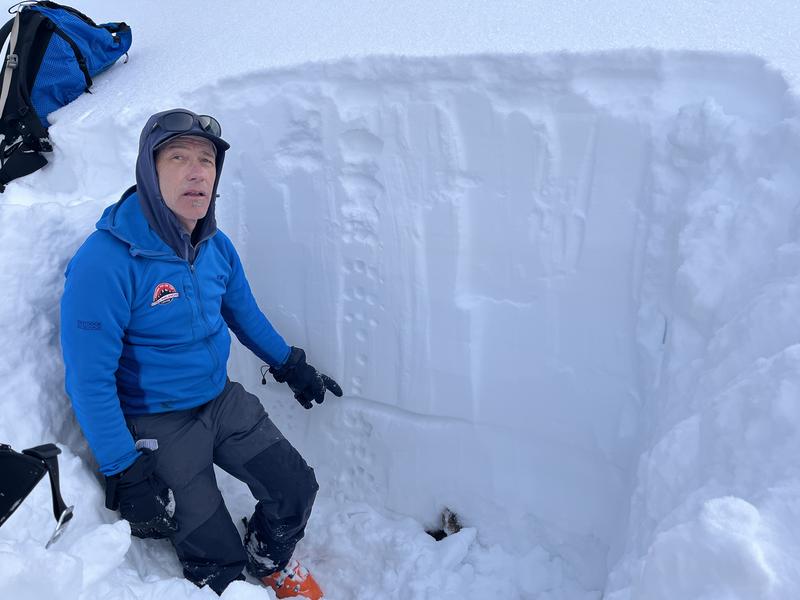
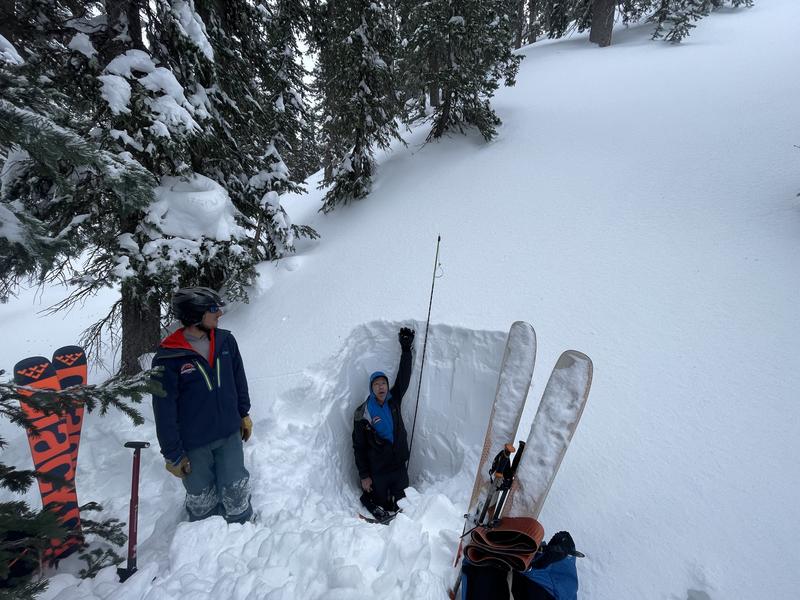
Photo illustrates what is now a thin weak layer of faceted snow about a meter below the surface. The weak layer used to be much thicker, and then snow beneath was much weaker and looser. Time, and compressive weight from above has helped to strengthen this layer, but it was still capable of producing an avalanche under the stress of a rapid, heavy load.
In most areas, the weak layer is deeply buried, and hence very difficult, if not impossible to affect by the weight of a skier or rider. The trick then, is to avoid areas where the snowpack is thinner such as in wind exposed terrain, along slope margins and near rocky outcrops, and in areas of very steep, rocky, radical terrain.
Additional Information
General Announcements
This forecast is from the U.S.D.A. Forest Service, which is solely responsible for its content. This forecast describes general avalanche conditions and local variations always occur. This forecast will be updated by 7:30 tomorrow morning.