UDOT PLANNED AVALANCHE CLOSURES!!

Forecast for the Moab Area Mountains

Dave Garcia
Issued by Dave Garcia for
Wednesday, January 18, 2023
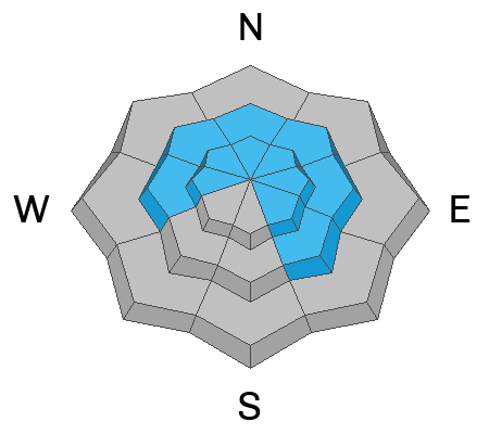
The storm rages on and dangerous avalanche conditions have developed in the mountains. Heavy snowfall and strong winds have created a CONSIDERABLE danger for triggering an avalanche in wind drifted snow on all aspects above treeline and on slopes that face NW-N-NE-E near treeline. Human triggered avalanches are LIKELY in these areas.

All other slopes have a MODERATE danger, where human triggered wind drifts as well as avalanches running in the new snow, are POSSIBLE.

Careful snowpack evaluation, cautious route-finding, and conservative decision making are essential for backcountry travel today.
Low
Moderate
Considerable
High
Extreme
Learn how to read the forecast here
Special Announcements
*The Loop Road from the Castle Valley Side will be closed until probably Thursday while plow crews deal with other areas*
Our Backcountry 101 class is full. We look forward to seeing everyone this weekend!
Road Conditions: The Geyser pass road was plowed yesterday. With abundant low elevation snow, expect travel to be difficult. Good clearance and 4x4 required, chains recommended.
Grooming: All trails will be covered in new snow today.
Weather and Snow
24 Hour Snow 12" 72 Hour Snow 26" Season Total Snow 168" Base Depth at Gold Basin 86"
Winds on Pre Laurel Peak N/A Temp 12

Weather
It just keeps coming. The La Sals have picked up another foot of snow in the last 24 hours. Snow showers will continue this morning as the upper level low is passing across the area, and the main center is moving into Eastern Colorado. Wraparound moisture will continue to produce some precipitation in our area, but it looks like the main event is over. We could pick up an additional 1-2". Today will be cold with a high around 10 degrees and NW winds blowing 15-20 mph with gusts around 35 mph. Thursday will be clear and cold. Friday brings another chance for snow and it looks like we will see the sun on Saturday.
General Conditions
Today will be "one of those days." A foot a fresh in the last 24 hours makes for 32" at 3.2" SWE in the last three days. The skiing will be nothing short of phenomenal, but avalanche conditions continue to become more dangerous as the snow piles up. Winds have been blowing in the moderate range for several days and have now shifted to the NW. Expect to find fresh, unstable slabs of wind drifted snow near and above treeline. Recent drifts will be three feet deep or more on leeward slopes. Backcountry travelers should also expect to find instabilities within the recent storm snow. The snow is stacking up deep, and loose sluffs will be a real concern today.
The November persistent weak layer is deeply buried in most areas and is becoming harder to affect. Areas of concern include places where the snowpack is thinner like along slope margins, near rocky outcrops, or along steep convexities. We have added a significant load, 3.6" of water plus additional snow from wind drifting, since the storm began on Sunday. For now, let's steer clear of steep, northerly facing terrain until the storm is over and we can see how the weak layer handles this load.

Snowpack and Weather Data
Gold Basin Storm Stake (10,000')
Gold Basin SNOTEL site (10,000')
SNOTEL site near Geyser Pass Winter Trailhead (9600')
Wind Station on Pre-Laurel Peak (11,400')
NWS forecast for the La Sal Mountains.
Recent Avalanches
No new avalanches have been reported. Here is the La Sal Avalanche Database.
Ad
Avalanche Problem #1
Wind Drifted Snow
Type
Location
Likelihood
Size
Description
Strong Southerly winds have blown for days and have now shifted to the NW. We can expect gusts higher than 30 mph today. There is plenty of snow available for transport and backcountry riders can expect to find fresh, sensitive slabs of wind drifted snow on all aspects near treeline and above. Complicating the matter, recent storm snow will have buried drifts that formed over the last several days making them hard to identify. You can expect to find drifts more than three feet deep above treeline on slopes that face NW-N-E. You'll need to have a keen eye for recognizing fat, rounded pillows of wind drifted snow both new and old. Skiers and riders should avoid any steep slopes that have recent wind drifted snow.
Any avalanche triggered in new or wind drifted snow has the potential to step down to more deeply buried weak layers, causing larger and more dangerous avalanches.
Avalanche Problem #2
New Snow
Type
Location
Likelihood
Size
Description
In our recent travels we have experienced sluffing in the new snow on steep terrain. Sluffs and loose dry snow avalanches should be on your radar today. Use steep test slopes and ski cuts to see if loose, uncohesive surface snow moves down slope. In big, steep terrain, sluffs can easily knock a rider off their feet. Avoid steep terrain with terrain traps below.
The recent snow has the potential to form soft storm slabs. Cracking in the snow surface is a good indicator of this type of instability. Blocks of snow between your skis on the skin trail indicate that a slab has developed..
Avalanche Problem #3
Persistent Weak Layer
Type
Location
Likelihood
Size
Description
Heavy snowfall and wind drifting continues to put more pressure on the deeply buried persistent weak layer that formed in November. We have piled up about three feet of snow and 3.6 inches of water since Sunday. This layer has shown signs of strengthening and stability tests continue to be less reactive. It will certainly take a significant trigger to cause an avalanche to fail on this layer, and this series of storms might just be the straw that breaks the camel's back. With the recent heavy load, backcountry travelers should avoid all steep slopes that harbor this weak layer. Play it safe while the storm continues and let's wait to get eyes on big terrain once the weather clears up. If we don't see any avalanches breaking deep down on this weak layer during these storms, I think we can start to put this problem behind us.
Additional Information
General Announcements
This forecast is from the U.S.D.A. Forest Service, which is solely responsible for its content. This forecast describes general avalanche conditions and local variations always occur. This forecast will be updated by 7:30 tomorrow morning.