Forecast for the Moab Area Mountains

Eric Trenbeath
Issued by Eric Trenbeath for
Monday, January 15, 2024
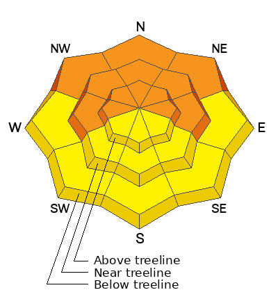
A CONSIDERABLE avalanche danger exists on all steep slopes facing W-N-E, near and above treeline, and on slopes facing NW-N-E below. Human triggered avalanches involving a buried persistent weak layer are likely in these areas.
A MODERATE avalanche danger exists on steep slopes facing SW-S-SE at all elevations, and on W and E aspects below treeline. Human triggered avalanches failing on a buried persistent weak layer are possible.

Incremental loading from recent and wind drifted snow has begun to stress a faceted weak layer in the snowpack on all aspects and we are developing one of the more treacherous snowpacks I've seen in some time. Avoiding slopes steeper than 30 degrees is the only safe option out there right now.
Low
Moderate
Considerable
High
Extreme
Learn how to read the forecast here
Special Announcements
With the arrival of new snow, sign up for our Backcountry 101 course Jan 19, 20!
Sign up for forecast region-specific text message alerts. You will receive messages about changing avalanche conditions, watches, and warnings.
Follow us on Instagram @utavy_moab
Road Conditions: The Geyser Pass Road will not be plowed today. Many vehicles made it up yesterday but several also got stuck. 4x4 with good tires is required. Plowing is scheduled for Tuesday.
Grooming: LUNA rolled Gold Basin through Geyser Pass yesterday.
Weather and Snow
6:00 a.m. Snow and Weather Data
24 Hour Snow 1" 72 Hour Snow 6" Season Total Snow 77" Base Depth at Gold Basin 37"
Winds on Pre-Laurel Peak: W 0-5 Temp 23˚ F

Weather
Winds have finally taken a powder so to speak and conditions are remarkably calm. Look for isolated showers this morning with gradually clearing skies and increasing northwest winds as the day goes on. High temps will be near 20F today, and will crater to near zero tonight. Look for sunny skies on Tuesday and a chance for snow on Wednesday.
General Conditions
5" of dense, new snow greatly improved conditions yesterday, and you should be able to find good snow out there today. The good news is that we've had about 3' of new snow since January 5. The bad news is that all the recent snow has settled into cohesive slab over the December drought layer, and a persistent weak layer is now our number one problem. In our travels yesterday, Dave Garcia and I observed fairly widespread collapsing and cracking of the slab over the weak layer, and this problem is not limited to northerly aspects. Travis Nauman first noted problems on south aspects (see his observation here), and Dave and I had reactive stability tests yesterday on a SW facing slope. The problem is not as widespread on southerly aspects do to thin snow cover, but any slope with enough snow to ride at this point should be considered suspect.
Snowpack and Weather Data
Gold Basin Storm Stake (10,000')
Gold Basin SNOTEL site (10,000')
SNOTEL site near Geyser Pass Winter Trailhead (9600')
Wind Station on Pre-Laurel Peak (11,400')
NWS forecast for the La Sal Mountains.
Ad
Avalanche Problem #1
Persistent Weak Layer
Type
Location
Likelihood
Size
Description
A slab of cohesive snow now exists above a persistent weak layer of faceted snow on all aspects. This weak layer formed during the December dry spell. Near treeline and above, elevated winds have stiffened the snow and produced slabs of wind drifted snow over top of this weak layer. The layer is most widespread on slopes facing W-N-E, where winds have built thicker slabs on top, but it's also becoming reactive on southerly aspects. The bottom line is that we are developing one of the more treacherous snowpacks I've seen in a long time, with a widespread persistent weak layer, and incremental loading exacerbated by the wind. We're going to need to tread lightly and avoid avalanche terrain for some time.
The video below is of an extended column test performed on a SW aspect on Sunday, January 14.
Avalanche Problem #2
Wind Drifted Snow
Type
Location
Likelihood
Size
Description
Shifting winds have hammered the mountains alternately scouring and drifting snow on to all aspects. On steep, northerly facing slopes, slabs of wind drifted snow are stressing the "December drought layer," and deep and dangerous avalanches are likely in these areas. Wind slabs have also formed on south facing slopes where they alternate with areas of very shallow snow or even bare ground. Look for slabs on the leeward sides of ridge crests and terrain features such as gully walls and subridges. They are often recognizable by their smooth, rounded appearance, and cracking is a sign of instability. Old hard slabs will support your weight initially and they may sound hollow underneath. Hard slabs may lure you further down slope before breaking well above you. Avoid steep, wind drifted slopes.
Additional Information
To fulfill our mission, the UAC relies on our amazing backcountry community. Your support helps pay for the daily avalanche forecast, free awareness presentations across the state, and new tools like the new Avalanche and Observation Explorer. As we welcome the new year, please consider donating to the UAC.
General Announcements
This forecast is from the U.S.D.A. Forest Service, which is solely responsible for its content. This forecast describes general avalanche conditions and local variations always occur.