Forecast for the Moab Area Mountains

Eric Trenbeath
Issued by Eric Trenbeath for
Sunday, January 14, 2024
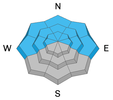
A CONSIDERABLE avalanche danger exists on all aspects near treeline and above.
On steep slopes facing W-N-E, up to 3' of accumulated snowfall and strong winds over the past week have built dangerous slabs over a widespread persistent weak layer, and deep and dangerous human triggered avalanches are likely.

On southerly aspects, strong northerly winds have built unstable slabs of wind drifted snow on top of weak sugary snow. Slopes steeper than 30 degrees that have recent deposits of wind drifted snow should be avoided.

A MODERATE danger exists on all aspects below treeline and human triggered avalanches are possible.
Low
Moderate
Considerable
High
Extreme
Learn how to read the forecast here
Special Announcements
With the arrival of new snow, sign up for our Backcountry 101 course Jan 19, 20!
Sign up for forecast region-specific text message alerts. You will receive messages about changing avalanche conditions, watches, and warnings.
Follow us on Instagram @utavy_moab
Road Conditions: The Geyser Pass Road will not be plowed today. Expect several inches of new and wind drifted snow. 4x4 or AWD with good tires are required.
Grooming: LUNA will be up grooming trails today.
Weather and Snow
6:00 a.m. Snow and Weather Data
24 Hour Snow 5" 72 Hour Snow 8" Season Total Snow 76" Base Depth at Gold Basin 37"
Winds on Pre-Laurel Peak: WSW 15-20 G30 Temp 23˚ F

Weather
Atmospheric River moisture driven by northwest flow is pounding northern Utah, with Little Cottonwood Canyon storm accumulations over the last several days now approaching 70" at nearly 6.0" of water. A weak shortwave associated with this powerful system is driving weather down here where we picked up another 5" overnight accompanied by moderate to strong WSW winds. Showers should linger through this morning with continued strong winds shifting to more westerly. Temperatures will be warmer today rising into the mid 20's at 10,000'. Look for clearing skies and continued breezy conditions tomorrow.
General Conditions
Snow continues to trickle in and we are up to around 3' since January 5. In sheltered areas, the recent snow has settled into a cohesive soft slab over top of our weak, underlying snowpack. The good news is that this has made the snowpack more supportable for skiing and riding. The bad news is that a persistent weak layer under this slab is now our number one problem. Collapsing and whumphing are becoming more widespread (see this observation from Sam Van Wetter). These red flag signs of instabilty are the effects of a person's weight collapsing a slab over a weak layer.
In the wind zone, shifting wind directions have alternately stripped, scoured, and loaded all aspects. Travis Nauman was up yesterday and he said he has "not seen Gold Basin as completely wind affected really ever." Read his complete observation here. This amounts to a wide variety of surface conditions and difficult to ascertain loading patterns. On northerly facing slopes, soft and hard slabs of wind drifted snow 2' thick or more have developed over a wide spread persistent weak layer. On southerly aspects, Travis also reported collapsing slabs of wind drifted snow, with weak, faceted snow underneath. Distribution is more spotty on southerly aspects, but we may soon be looking at a persistent weak layer problem around the compass.
In short, it's not a friendly landscape out there. Conditions are challenging, thin, and dangerous. Seek out sheltered, low angle slopes and meadows for the best, and safest, turning and riding.
Wind affected snow surface courtesy of Travis Nauman.
Snowpack and Weather Data
Gold Basin Storm Stake (10,000')
Gold Basin SNOTEL site (10,000')
SNOTEL site near Geyser Pass Winter Trailhead (9600')
Wind Station on Pre-Laurel Peak (11,400')
NWS forecast for the La Sal Mountains.
Ad
Avalanche Problem #1
Persistent Weak Layer
Type
Location
Likelihood
Size
Description
The underlying snow pack is weak, but the December drought layer (buried roughly 15 inches deep) is the primary layer of concern. This layer of weak, faceted snow formed near the surface during the December dry spell. A slab now exists on top of this persistent weak layer. Near treeline and below, storm snow over the past week has settled into a thick, cohesive slab. Near treeline and above, elevated winds have stiffened the snow and produced slabs of wind drifted snow over top of this weak layer. This persistent weak layer is most widespread on slopes facing W-N-E, but faceted snow is turning up on all aspects, and it may only be a matter of time before we consider this problem to be widespread.
The video below of an extended column test illustrates the slab's ability to propagate and produce an avalanche:
Avalanche Problem #2
Wind Drifted Snow
Type
Location
Likelihood
Size
Description
Shifting winds continue to hammer the mountains alternately scouring and drifting snow on to all apsects. On steep, northerly facing slopes, slabs of wind drifted snow are stressing the "December drought layer," and deep and dangerous avalanches are likely in these areas. Wind slabs have also formed on south facing slopes where they alternate with areas of very shallow snow or even bare ground. Look for slabs on the leeward sides of ridge crests and terrain features such as gully walls and subridges. They are often recognizable by their smooth, rounded appearance, and cracking is a sign of instability. Old hard slabs will support your weight initially and they may sound hollow underneath. Hard slabs may lure you further down slope before breaking well above you. Avoid steep, wind drifted slopes.
Additional Information
To fulfill our mission, the UAC relies on our amazing backcountry community. Your support helps pay for the daily avalanche forecast, free awareness presentations across the state, and new tools like the new Avalanche and Observation Explorer. As we welcome the new year, please consider donating to the UAC.
General Announcements
This forecast is from the U.S.D.A. Forest Service, which is solely responsible for its content. This forecast describes general avalanche conditions and local variations always occur.