Join us at our 2nd Annual Blizzard Ball

Forecast for the Logan Area Mountains

Toby Weed
Issued by Toby Weed on
Friday morning, April 10, 2020
Heightened wet avalanche conditions and MODERATE danger will develop again today on steep slopes at all elevations in the Logan Zone. Very warm daytime temperatures, a poor overnight refreeze, and high angle April sun will cause increasing danger of wet avalanches. People could trigger wet loose and perhaps dangerous wet slab avalanches in very steep terrain, and some natural activity is possible.
  • Evaluate snow and terrain carefully.
Low
Moderate
Considerable
High
Extreme
Learn how to read the forecast here
Special Announcements
The Avalanche Research Program at Simon Fraser University is conducting an online survey to examine how people use avalanche safety information. They want to hear from all backcountry users to understand how they process information provided in public avalanche forecasts. Anyone who completes the survey before May 15th will be entered to win cash prizes.
Uncertainty, Risk, & Decision Making: before, during, and after COVID-19 - Read this thought-provoking blog post about how we take risks by guest author Tom Diegel.
Weather and Snow
It's pretty warm again this morning, with temperatures hovering near freezing in the mountains and around 40°F at lower elevations. Temperatures climbed to 56°F yesterday, and there is 90 inches of total snow at the 8400' Tony Grove Snotel with 111% of normal Snow Water Equivalent. It's 28°F at the 9700' CSI Logan Peak weather station this morning, and winds are currently blowing about 10 mph from the west-southwest.

Warming daytime temperatures and intense high angle sun will cause increasing probability of wet loose avalanches during the day at all elevations. People could trigger dangerous wet slab avalanches on very steep sunny slopes and under rock outcroppings or cliff bands. Nighttime temperatures will drop into the teens over the weekend, and the wet snow will freeze solidly and become much more stable even on warm sunny days.
Evaluate terrain carefully and continue to practice safe travel protocols to minimize your risk during the current health crisis. Staying off and out from under slopes steeper than about 30 degrees is the best way to avoid problems.

Very warm daytime temperatures and powerful April sun are creating increasing and elevated wet avalanche conditions on steep slopes at all elevations in the Wellsville Range.
High pressure will build into the area Friday into early Saturday. A cold front will cross the area Saturday night into Sunday, with a cool northwest flow prevailing into next week.
Expect sunny and warm conditions in the mountains today again, with 8500' high temperatures climbing to around 49°F, and 7 to 10 mph west wind. It will be partly cloudy tonight, and low temperatures are expected to drop to around 28°F, with 10 to 14 mph west winds. Snow showers likely tomorrow afternoon, and some thunder is also possible. Skies will be partly sunny with high temperatures around 45°F and increasing 21 to 26 mph west winds with gusts around 40 mph.
Recent Avalanches
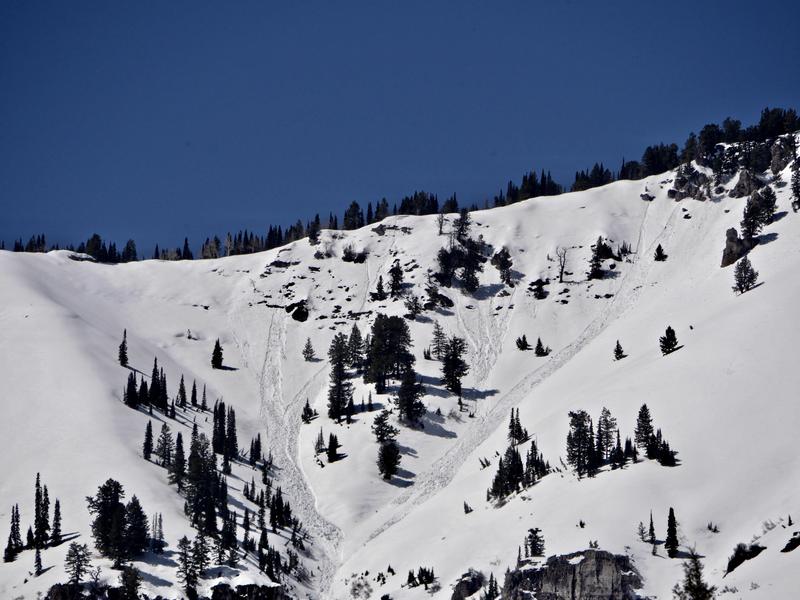
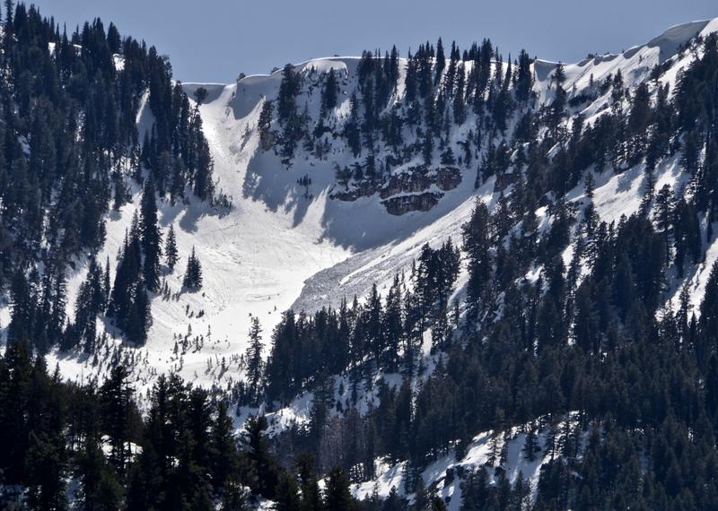
There have been several recent natural wet loose avalanches and cornice falls in the Logan Zone due to very warm temperatures in the mountains.
photo 4-9-2020, Wood Camp
photo 4-9-2020, Mill Hollow
Sunday, a solo skier triggered a dangerous wet slab avalanche on a southeast facing slope at around 7600' in central Wood Camp. Report is HERE
photo from 4-9-2020
Ad
Avalanche Problem #1
Wet Snow
Type
Location
Likelihood
Size
Description
Overnight temperatures hovered around freezing at most stations in the Logan Zone again. The saturated snow did not refreeze well and temperatures will warm throughout the day, the high angled April sun will be out. Elevated conditions for wet loose and wet slab avalanches will once again develop on steep slopes. Sunday's skier triggered wet slab avalanche in Wood Camp indicates potential for similar dangerous wet avalanche activity on very steep slopes across the zone. Very steep sunny slopes beneath rock outcroppings or cliff bands are particularly suspect.
  • Watch for loose, unconsolidated snow, roller balls, pin-wheels, and natural sluffs as telltale signs of instability.
  • If you or your machine starts sinking into saturated snow or if the snow where you are gets warm and slushy, you should move off of and out from under steep slopes.
  • Stay off and out from under large ridge top cornices, which could break much further back than expected and might trigger avalanches on steep slopes below. Cornices will sag and buckle in the daytime warmth, and some may calve large chunks.
Additional Information
Information on outdoor recreation - The State of Utah created this webpage with information about recreating on both state and federal public lands during the current health crisis.

Skiing and riding at closed ski resorts - Some resorts allow access now, and some do not. Please check HERE for the latest info on ski area access.

New to the backcountry (including riding at closed resorts) - Watch the award-winning, 15 minute Know Before You Go video, or take the 5-part, free online-learning series.
General Announcements
EMAIL ADVISORY. If you would like to get the daily advisory by email you subscribe HERE.
Remember your information can save lives. If you see anything we should know about, please help us out by submitting snow and avalanche observations....HERE. You can also call us at 801-524-5304, email by clicking HERE, or include #utavy in your tweet or Instagram.
This forecast is from the USDA Forest Service, which is solely responsible for its content. The forecast describes general avalanche conditions and local variations always occur.
We will update this forecast before about 7:30 tomorrow morning.