Forecast for the Logan Area Mountains

Paige Pagnucco
Issued by Paige Pagnucco on
Saturday morning, March 1, 2025
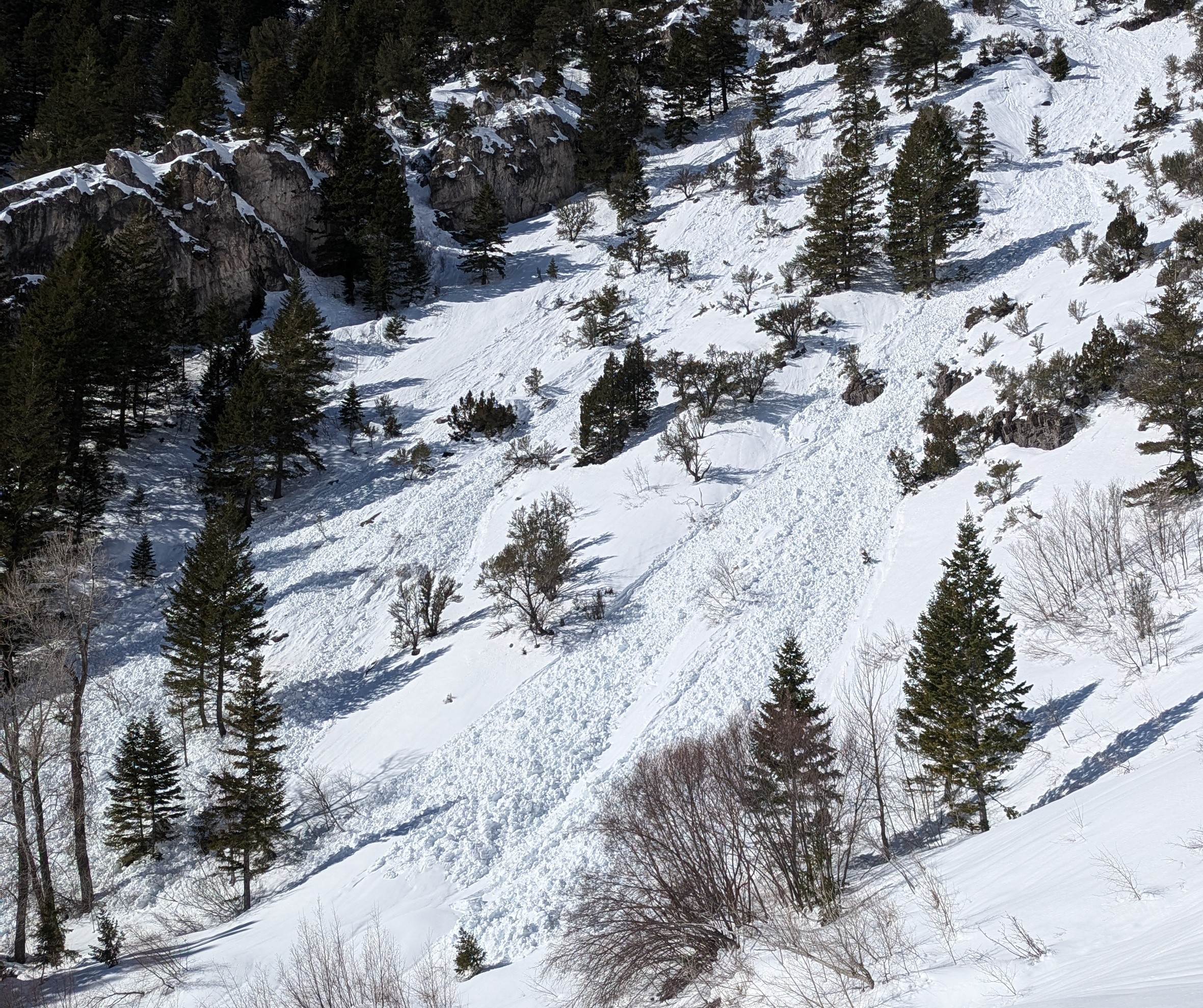
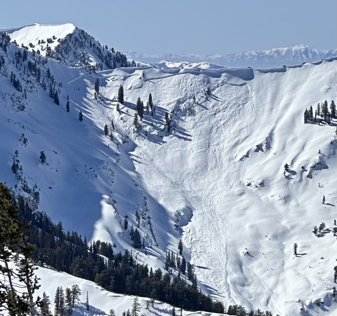
With a poor overnight refreeze and warm daytime temperatures, the avalanche danger is MODERATE today. Human-triggered and natural wet avalanches are possible in steep, sunny terrain. While unlikely, there is a potential for dangerous avalanches to be triggered in upper and mid-elevation terrain, where a persistent weak layer is buried 3 to 4 feet deep.
Evaluate the snow and terrain carefully, and continue to practice safe travel protocols.
Low
Moderate
Considerable
High
Extreme
Learn how to read the forecast here
Special Announcements
We are excited to announce the launch of our new mobile application, available on both Android and IOS. Get all the information you need to plan your backcountry adventure and keep the information at the tip of your fingers while you are out. Install the Android version HERE and the IOS version HERE.
Join the UAC on Thursday, March 6th at Brewvies in Salt Lake for friends, drinks, prizes, and an action-packed film! Alpine Assassins is a movie about incredible backcountry sledding and adventure. Doors open at 6:30 PM. Get your tickets HERE.
Weather and Snow
Expect another beautiful day in the mountains with sunshine and warm temperatures. The biggest difference between today and yesterday is that last night, temperatures stayed well above freezing. This means the snowpack did not refreeze thoroughly. We'll start the day with less stability, and wet avalanches may occur earlier in the day. If you are sinking deeply into the mashed potato snow, move to a cooler aspect or elevation or simply move away from steep terrain. With a decent temperature inversion in place this morning, I'd expect the snow to be somewhat unsupportable on upper and mid-elevation slopes that stayed warm overnight and more supportable in low-elevation terrain where temperatures got below freezing. If you venture into higher elevations, avoid traveling on or beneath overhanging cornices, as they are weakening due to the warm temperatures.

The Tony Grove Snotel at 8400 feet reports 35° F, with 90 inches of total snow. The high at Tony Grove yesterday was 52° F. It's 37° F at the Card Canyon weather station at 8800 feet, with 62 inches of total snow.
At 9700 feet at CSI's Logan Peak Wx station, winds are blowing 11 mph from the west-northwest and it's 37° F. On Paris Peak at 9500 feet, it's 36° F, with winds blowing 4 to 5 mph from the west-northwest.

Today, we'll have sunshine and warm temperatures with an 8500' high of 45° F or more. Winds are expected to be light, blowing from the northwest this morning and then switching to the south in the late morning. We'll hopefully get a better refreeze tonight, but cloud cover may get in the way. Sunday should also be another nice day, though we'll have a few more clouds ahead of an incoming storm beginning Sunday night/Monday morning. The multi-day storm is looking good right now and could deliver a decent shot of snow to refresh our soggy snowpack.

For more information, visit the UAC weather page here: Weather - Utah Avalanche Center
For Logan-specific weather, go here: Logan Mountain Weather - Utah Avalanche Center
Recent Avalanches
  • We checked out a large natural avalanche in Hell Canyon in the Wellsville Range that occurred with the strong westerly winds on Tuesday. We think it was triggered by cornice fall, and that it failed on a buried PWL. We estimate the avalanche on an east-facing slope at 8400 feet was about 4 feet deep x 700 feet wide, running 2200'vrt. Report is HERE.
  • Monday afternoon, I could see a large natural avalanche on the south face of Beirdneau Peak. Report is HERE. I'm not sure if this was a wet slab avalanche, but it was likely caused by solar warming and perhaps heat shock.
  • A snowmobiler triggered an avalanche near the warming hut in Boss Canyon on Saturday that unfortunately injured a rider who was below the slope. The large hard slab avalanche failed on a buried persistent weak layer and was 4 to 5 feet deep and about 500 feet wide. Read the preliminary report HERE.
Read about all avalanches and observations HERE.
Ad
Avalanche Problem #1
Wet Snow
Type
Location
Likelihood
Size
Description
Warm overnight temperatures did not refreeze the saturated surface snow, and we expect sunny skies and already warm mountain temperatures to climb during the day today, elevating the danger of wet avalanches even more. Loose wet avalanches are most likely in sunny terrain, especially near rock outcroppings and on slopes with shallow snow cover. More dangerous wet slab avalanches or heat-related slab avalanches failing on a buried PWL are possible on sunny slopes with poor snow structure. Southerly facing slopes at low elevations (<7000') are melted out or have only very shallow snow cover.
  • Roller balls, pinwheels, and natural sluffs are sure signs of instability.
  • If you start sinking into saturated snow, you should move off and stay out from under steep slopes.
Loose wet avalanches. (PC:KO)
Avalanche Problem #2
Persistent Weak Layer
Type
Location
Likelihood
Size
Description
While the likelihood of triggering an avalanche on a buried persistent weak layer is decreasing, the consequences of doing so are still significant. Large and dangerous avalanches failing on one of a few buried persistent weak layers remain possible, especially in areas with shallower snow and poor snow structure. The danger is most acute in upper-elevation terrain on rocky slopes with shallow snow cover facing northwest through southeast, but avalanches failing on a PWL are possible on slopes facing all directions.
  • People could trigger avalanches of previously wind-drifted snow that may then step down into deeper persistent weak layers.
  • You should stay away from and out from under deceptive ridge-top cornices, which often break further back than expected and can trigger avalanches on drifted slopes below.
A recent cornice fall-triggered avalanche near Cougar Mountain. (PC:Jensen)
Additional Information
General Announcements
-National Forest Winter Recreation Travel Maps show where it's open to ride: UWCNF Logan, Ogden LRD Tony Grove, Franklin Basin CTNF Montpelier
-For all questions on forecasts, education, Know Before You Go, events, online purchases, or fundraising, call 801-365-5522.
-Remember the information you provide could save lives, especially if you see or trigger an avalanche. To report an avalanche or submit an observation from the backcountry, go HERE.
-Receive forecast region-specific text message alerts to receive messages about changing avalanche conditions, watches, and warnings. Sign up and update your preferences HERE.

This forecast is from the U.S.D.A. Forest Service, which is solely responsible for its content. This forecast describes general avalanche conditions, and local variations always occur.