Forecast for the Logan Area Mountains

Toby Weed
Issued by Toby Weed for
Monday, February 20, 2023
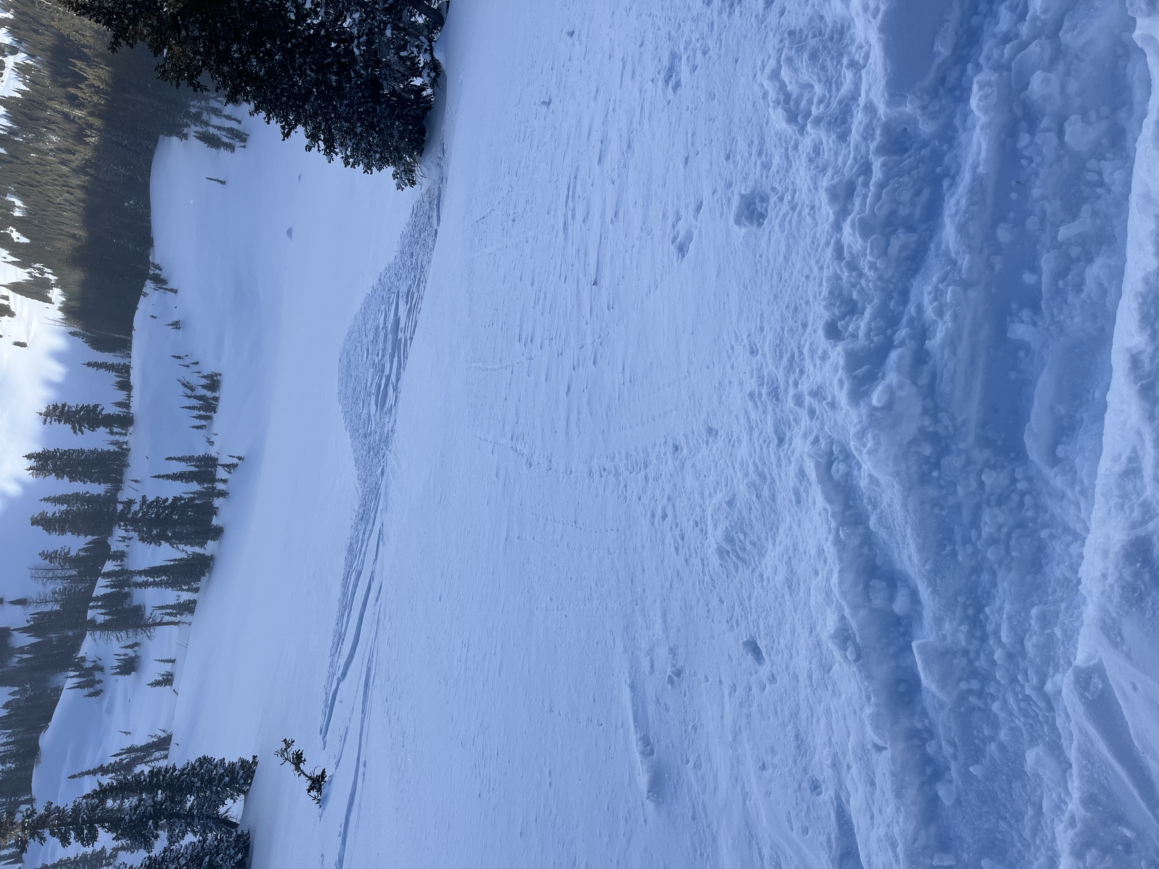
Heavy snowfall and drifting by strong winds from the west will elevate backcountry avalanche danger today. Expect CONSIDERABLE danger to develop on drifted slopes at upper and mid elevations, where people are likely to trigger avalanches of wind drifted snow on slopes steeper than 30°. Heightened avalanche conditions and MODERATE danger will also be found at lower elevations, where wind drifted snow is overloading some slopes plagued by sugary weak layers. Safer conditions and nice powder can be found in lower angled terrain and where the snow was not affected by the wind.
  • Make conservative decisions and evaluate snow and terrain carefully.
Low
Moderate
Considerable
High
Extreme
Learn how to read the forecast here
Weather and Snow
Soft and harder wind slab avalanches are possible today in windy terrain at all elevations, and they're more likely and could be larger at upper elevations. The snow is much more stable in sheltered areas and we found great powder yesterday, especially in northerly facing terrain.
Looking ahead, light snow from yesterday's little storm capped and preserved existing weak surface snow and widespread shallowly buried persistent weak layers. It looks like we're in for quite a storm that could drop a few feet of snow and tons of SWE, which will overload slopes with poor snow structure. Last week and yesterday I found areas with layers of very weak sugary or faceted snow on slopes facing all directions and at all elevations, especially worrisome to me is that faceted snow is widespread at lower elevations (below around 7500')

The 8400' Tony Grove Snotel reports another couple inches overnight on top of the 7 inches of new snow from yesterday, with .8" SWE all told. It's 24° F this morning, and there is 100 inches of total snow., The winds at the CSI weather station at 9700' on Logan Peak are from the west-southwest, blowing around 30 to 35 mph, gusting in the 50s.

Here is the NWS point forecast for high elevations in the Central Bear River Range:
Washington's Birthday: Snow. The snow could be heavy at times. High near 27. Wind chill values as low as 6. Breezy, with a west wind 23 to 26 mph, with gusts as high as 40 mph. Chance of precipitation is 90%. Total daytime snow accumulation of 4 to 8 inches possible.
Tonight: Snow likely, mainly after 11pm. The snow could be heavy at times. Cloudy, with a temperature rising to around 26 by 1am. Wind chill values as low as 6. Windy, with a west wind 23 to 28 mph increasing to 29 to 34 mph after midnight. Winds could gust as high as 50 mph. Chance of precipitation is 70%. New snow accumulation of 5 to 9 inches possible.
Tuesday: Snow. The snow could be heavy at times. High near 27. Wind chill values as low as 6. Windy, with a west southwest wind 26 to 34 mph, with gusts as high as 50 mph. Chance of precipitation is 100%. New snow accumulation of 15 to 21 inches possible.
***The productive storm is strengthening and will likely last through much of the week, with significant accumulations possible, measured in feet, in the mountains of Utah and Idaho.
Recent Avalanches
Over the weekend skiers in the Central Bear River Range and near Logan Peak remotely triggered a few small wind slab avalanches. Saturday report is HERE

Just like others from Saturday, this shallow wind slab avalanche was remotely triggered from above yesterday. Remotely triggered avalanches indicate the presence of an active weak layer.....
For a list of avalanches in the Logan Zone go HERE
Find a list of all recent observations & avalanches from across Utah HERE.
Ad
Avalanche Problem #1
Wind Drifted Snow
Type
Location
Likelihood
Size
Description
  • Avoid corniced slopes and stiffer drifts on steep slopes near ridges and in and around terrain features like cliff bands, sub-ridges, mid-slope break-overs, and gully walls.
  • Last week and over the weekend shallow wind slabs formed on weak surface snow. These continue to build today and could be sensitive to triggering by people.
  • Wind slabs consist of stiffer drifted snow. Today, soft slab avalanches of drifted storm snow are most likely, but hard wind slabs also formed before the snow fell and some of these could still be sensitive to triggering.
  • Hard wind slabs sometimes allow people to get out on them before releasing like a big mouse trap. They are often rounded and chalky looking and can make hollow, drum-like sounds.
  • Some harder wind slabs are probably now hidden by fresh powder.
Avalanche Problem #2
New Snow
Type
Location
Likelihood
Size
Description
Small soft slab and loose avalanches of storm snow are possible in steep terrain. The danger of storm snow avalanches will increase as snow stacks up this afternoon, overnight, and especially tomorrow, with a few feet of accumulation possible.
Even small avalanches of wind drifted or loose snow can be a problem, especially if you get carried into trees, gullies, benches, or rocks.
Additional Information
General Announcements
  • Please submit your observations from the backcountry HERE.
  • For a list of avalanche classes from the Utah Avalanche Center go HERE
  • For information on where you can ride your sled or snowbike, check out this map of the winter travel plan for the Logan and Ogden Ranger Districts HERE, and a close up of the Tony Grove and Franklin Basin Areas HERE.
This forecast is from the U.S.D.A. Forest Service, which is solely responsible for its content. This forecast describes general avalanche conditions and local variations always occur.