Get Your Ticket to the 32nd Annual Backcountry Benefit on September 11th! Support Forecasting, Awareness, and Education
Ad

Forecast: Logan Area Mountains

Forecast for the Logan Area Mountains

Toby Weed
Issued by Toby Weed on
Monday morning, December 30, 2019
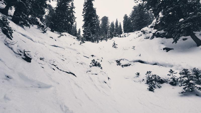
Shallow powder conditions are quite nice, snow is stable, and the danger LOW on most slopes in the Logan Area Backcountry. Unfortunately, recent northwest winds created soft drifts of new snow that could be sensitive near ridge tops and in some steep upper elevation terrain. Although unlikely to be much of a problem, people might trigger small avalanches of new or wind drifted snow.
  • Use normal caution.
  • Evaluate upper elevation snow and terrain carefully.
Low
Moderate
Considerable
High
Extreme
Learn how to read the forecast here
Weather and Snow
It's 14°F at the 8400' Tony Grove Snotel this morning, and there's about 4 inches of light new snow from yesterday. There is 46 inches of total snow, with 99% of average SWE for the date. It's 11°F on Logan Peak, and the wind is blowing from the north-northwest this morning around 10 mph.
The avalanche danger is Low and very nice shallow powder snow is stable on most slopes in the Logan Zone. Avalanches are generally unlikely, but possibility still exists for people to trigger avalanches, mainly on drifted upper elevation slopes. People should also continue to avoid very steep rocky slopes with thin snow cover. Looks like 2019 will end with fairly nice weather, but 2020 is likely to come in with rapidly rising avalanche danger. A potent Pacific winter storm will impact the area on New Years Day, with significant accumulations and strong winds possible in the mountains.
Yesterday's powder was so light it was hard to measure. Some report about 6 inches of super light fluff fell on upper elevation slopes.

It will be cloudy in the mountains today, and there is a chance of some scattered snowfall in the morning, with little accumulation expected. 8500' high temperatures around 19°F, northwest wind 7 to 9 mph, and wind chill values as low as -11°F. It will be mostly cloudy tonight, with low temperatures around 1°F, and 6 to 11 mph north-northwest winds causing wind chill values around -14°F. It will be partly sunny in the mountains tomorrow, with high temperatures near 19°F, north-northwest wind 7 to 9 mph, and wind chill values around -3°F. Snow is likely to begin falling late on New Years Eve, with a foot or two of accumulation possible on mountain slopes inthe Bear River range by Thursday, 1-2-20.
Recent Avalanches
Other than some minor sluffing, no new avalanches were reported in the Logan Zone since natural activity during the mid December Storm.
The large crown of an avalanche from mid December is still visible on the north side of White Pine Knob
Ad
Avalanche Problem #1
Normal Caution
Type
Location
Likelihood
Size
Description
Although it is unlikely for a person to trigger an avalanche, it is still possible, especially on very steep upper elevation slopes. Use normal caution means being situationally aware and prepared for possible avalanches.
  • Everyone in your party needs to have and know how to efficiently use a beacon, probe, and shovel.
  • Cross steep slopes or possible avalanche paths one-at-a-time while the rest of your party watches from a safe area.

Human triggered avalanches involving wind drifted snow are possible on some upper elevation slopes. Northwest winds continued yesterday and diminished a bit overnight, drifting fresh and very light snow into upper elevation deposition zones.
  • Even small avalanches can be quite dangerous in shallow snow conditions.
  • Watch for and avoid stiffer drifted snow near ridge lines and in and around terrain features like cliff bands, scoops, gully walls, and sub-ridges

The sugary October persistent weak layer near the ground on northerly facing upper elevation slopes appears to be dormant for now, but it's still a good plan to avoid steep, thin, rocky terrain.
General Announcements
Thanks to the generous support of our Utah ski resorts and Ski Utah, we have discount lift tickets available. All proceeds from these go towards paying for avalanche forecasting and education! Get your tickets HERE.
EMAIL ADVISORY. If you would like to get the daily advisory by email you subscribe HERE.
Remember your information can save lives. If you see anything we should know about, please help us out by submitting snow and avalanche observations....HERE. You can also call us at 801-524-5304, email by clicking HERE, or include #utavy in your tweet or Instagram.
This forecast is from the U.S. Forest Service, which is solely responsible for its content. This forecast describes general avalanche conditions and local variations always occur. I will update this advisory before about 7:30 tomorrow morning.