Join us for the 17th Annual Professional Snow and Avalanche Workshop (PROSAW) on November 4 - Purchase tickets here!

Forecast for the Logan Area Mountains

Toby Weed
Issued by Toby Weed on
Saturday morning, January 7, 2023
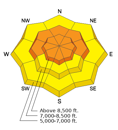
There is CONSIDERABLE danger on all upper elevation slopes and mid elevation slopes facing west, north, and east, where people could trigger large and dangerous avalanches failing on a persistent weak layer buried 2 to 5 feet deep. Also small avalanches of wind drifted new snow are likely on slopes steeper than 30° Avalanche accidents are common on bluebird powder days that come after a prolonged stormy period.
  • Careful snowpack evaluation, cautious route finding, and conservative decision-making are essential for safe backcountry travel.
Low
Moderate
Considerable
High
Extreme
Learn how to read the forecast here
Weather and Snow
Although stability is improving and obvious signs of instability may be less frequent or even absent, elevated avalanche conditions exist on all slopes above the Christmas Storm rain/snow-line. The snow at lower elevations was saturated by rain during the New Years storm, and much cooler temperatures since then formed solid refrozen crusts.
We've been able to find really nice and safer conditions in the meadows, on slopes at all elevations less steep than 30°, and at lower elevations.

Should be a lovely bluebird powder day in the backcountry. We've often seen avalanche accidents on the first nice day after an extended stormy period, and I'm afraid to say that the table is set for today. There is 10 inches of new powder snow from yesterday's storm at the 8400' Tony Grove Snotel site, where there is 75 inches of total snow, and it's 24° F. The wind is blowing 15 to 20 mph from the west at the 9700' CSI Logan Peak weather station.
Today it'll be mostly sunny and high temperatures at 8500' will be around 29°F. The wind will continue to blow out of the west this morning but switch around from the south this afternoon. Expect mostly cloudy conditions tonight, with low temperatures around 15° F, and winds continuing from the south around 14mph. Tomorrow will be partly sunny in the morning, but there's a good chance of snow showers after 11:00 and it'll be breezy, with increasing winds blowing from the south-southwest 15 to 22 mph and gusting in the 30s.
Recent Avalanches
Skiers found evidence of a recent large natural avalanche from around New Years in upper Logan Dry Canyon on a northwest facing slope at around 9000' in elevation. The avalanche failed on a buried persistent weak layer and was about 250 feet wide. The skiers observed no red flags and a snowpit dug nearby before they saw the avalanche showed deep, apparently stable snow.. HERE
We went up to look at the New Years avalanche on Red Pine Ridge on Wednesday... See avalanche report HERE.

Be sure to check out all observations HERE.
Ad
Avalanche Problem #1
Persistent Weak Layer
Type
Location
Likelihood
Size
Description
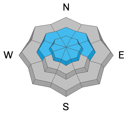
In many places, people could trigger large and dangerous avalanches failing on a deeply buried sugary persistent weak layer. Such an avalanche could be triggered remotely, from a distance or below. The persistent weak layer from November is now buried 2-5 feet deep, and any avalanche that fails on it will likely be hundreds of feet wide.
In upper elevation terrain in areas with a deep snowpack stability has apparently improved. Poor snow structure still exists in many places, but the buried persistent weak layer from November is buried so deeply under a thick slab that it is unlikely a person could cause a collapse. The problem is that a person could trigger the slope from an area where the slab is shallower, and a dangerous hard slab avalanche could result. Also, it appears that there are plenty of areas in the Logan Zone where the overall depth of the snowpack is shallower and the snow structure obviously worse. Recent natural and remotely triggered avalanches and snowpit test results from Friday show this to be the case.
Avalanche Problem #2
Wind Drifted Snow
Type
Location
Likelihood
Size
Description
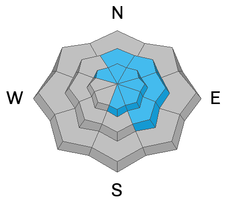
The fresh wind slabs from yesterday's storm could avalanche if triggered or they'll simply add more weight to slopes with existing poor snow structure. A smaller wind slab avalanche overrunning a slope with a poor snow structure could cause a much larger avalanche to step down to our now deeply buried November persistent weak layer.
  • Of course, people should avoid and stay out from under all slopes with accumulations of drifted new snow.
  • Watch for and avoid drifts on the lee side of major ridges, on corniced slopes, and in and around terrain features like cliff bands, gully walls, sub ridges, saddles, and sinks.
Avalanche Problem #3
New Snow
Type
Location
Likelihood
Size
Description
Shallow soft slabs and loose avalanches or sluffs of new snow are possible in steep terrain at all elevations. These are generally manageable but might be a problem in steep terrain if they sweep you into a tree or other terrain trap.
General Announcements
  • Remember, when you leave the ski area boundary, Beaver Mt or Cherry Peak, you are entering the backcountry, and you could trigger dangerous avalanches.
  • Please submit your observations from the backcountry HERE.
  • For a list of avalanche classes from the Utah Avalanche Center go HERE
  • For information on where you can ride your sled or snowbike, check out this map of the winter travel plan for the Tony Grove and Franklin Basin Areas HERE.
This forecast is from the U.S.D.A. Forest Service, which is solely responsible for its content. This forecast describes general avalanche conditions and local variations always occur.