Sign Up for the Utah Snow and Avalanche Workshop (USAW) on December 7th!

Forecast for the Logan Area Mountains

Toby Weed
Issued by Toby Weed on
Wednesday morning, January 4, 2023
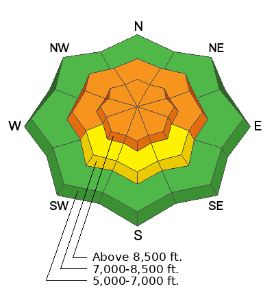
CONSIDERABLE avalanche danger exists on upper and mid elevation slopes in the backcountry. People are likely to trigger large and dangerous avalanches, and these might be triggered from a distance or below. Except for areas threatened from above, the danger is much lower at low elevations, below about 7500' where rain saturated the shallow snow and colder temperatures have since frozen it solid.
  • Careful snowpack evaluation, cautious route finding, and conservative decision-making remain essential for safe backcountry travel.
  • We've been able to find great shallow powder and safe conditions in the meadows, on slopes at all elevations less steep than 30°, and at lower elevations.
Low
Moderate
Considerable
High
Extreme
Learn how to read the forecast here
Weather and Snow
We've been able to find fantastic, fast and fun powder conditions at low elevations and in safe lower angled terrain (less steep than 30°) in the backcountry. The snow at lower elevations was saturated by rain during the New Years storm, and much cooler temperatures since then formed solid refrozen crusts. The hard, stable snow is now capped by several inches of nice powder, and offers a safe backcountry option and smooth and fast conditions for travel in lower angled terrain.

About 4 inches of light new snow fell in the last 24 hours on upper elevations in the Central Bear River Range. It's a steady16° F and there is 6 feet of total snow (72 inches) at the 8400' Tony Grove Snotel site. Winds are blowing 20 mph from the west and it's 9° F at the CSI Logan Peak weather station at 9700'.
It'll be cloudy with a few lingering snow showers this morning. High temperatures at 8500' will be around 23°F, and winds will blow 15 to 20 mph out of the west-southwest on the ridges. Expect mostly cloudy skies tonight, with low temperatures in the teens and 15 mph wind from the west. Snow is expected Thursday and Friday, with a modest 4 to 8 inches of accumulation expected.
Recent Avalanches
Riders found a recent large avalanche on Sunday in Richard's Hollow off Red Pine Ridge near Adam's Corral and above White Rock Spring... The avalanche was reported as being naturally triggered, but it also could have been remotely triggered by riders on Red Pine Ridge. The avalanche failed on a buried persistent weak layer and was around 3 feet deep and 500 feet wide, and it ran around 800 vrt'. See Report HERE.
We couldn't see much of the high country again yesterday, but reports of natural avalanches across Utah are filtering in.
Be sure to check out all observations HERE.
Ad
Avalanche Problem #1
Persistent Weak Layer
Type
Location
Likelihood
Size
Description
Heavy snow and drifting from the New Years Storm created slabs of unstable snow on slopes with a sugary persistent weak layer buried 2 to 4 feet deep.
In many places, people are likely to trigger large and dangerous avalanches failing on a deeply buried sugary persistent weak layer. Such an avalanche could be triggered remotely, from a distance or below. The persistent weak layer from November is now buried 2-4 feet deep, and any avalanche that fails on it will likely be hundreds of feet wide.
In upper elevation terrain in the Bear River Range areas with a deep snowpack stability has apparently improved. Poor snow structure still exists in many places, but the buried persistent weak layer from November is buried so deeply that it is unlikely a person could cause a collapse. The problem is that a person could trigger a dangerous hard slab avalanche from an area on the slope where the slab is shallower.
And, it appears that there are areas in the Logan Zone where the overall depth of the snowpack is shallower and the snow structure obviously worse. Recent natural and remotely triggered avalanches show this to be the case.
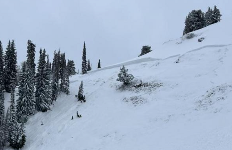
Here's a picture of a part of the crown line of an avalanche from Sunday off Red Pine Ridge. The avalanche that failed on the November PWL either naturally occurred shortly before it's discovery or it might have been remotely triggered by riders on Red Pine Ridge.
Avalanche Problem #2
Wind Drifted Snow
Type
Location
Likelihood
Size
Description
East and northeast winds were fairly strong at upper elevations Sunday and Monday. This is a somewhat unusual wind direction for sustained winds to blow from and in exposed terrain snow was drifted onto slopes with shallower snow that are on the prevailing windward side of the ridges. Tuesday, southwest and west winds drifted the nice New Years powder.
  • Cracking is a obvious sign of unstable snow.
  • Of course, people should avoid and stay out from under all slopes with significant accumulations of drifted new snow.
  • Watch for and avoid drifts in unusual or unexpected places and in and around terrain features like cliff bands, gully walls, sub ridges, saddles, and sinks.
General Announcements
  • Remember, when you leave the ski area boundary, Beaver Mt or Cherry Peak, you are entering the backcountry, and you could trigger dangerous avalanches.
  • Please submit your observations from the backcountry HERE.
  • For a list of avalanche classes from the Utah Avalanche Center go HERE
  • For information on where you can ride your sled or snowbike, check out this map of the winter travel plan for the Tony Grove and Franklin Basin Areas HERE.
This forecast is from the U.S.D.A. Forest Service, which is solely responsible for its content. This forecast describes general avalanche conditions and local variations always occur.