Join us for the 17th Annual Professional Snow and Avalanche Workshop (PROSAW) on November 4 - Purchase tickets here!

Forecast for the Logan Area Mountains

Paige Pagnucco
Issued by Paige Pagnucco on
Sunday morning, January 21, 2024
The avalanche danger is CONSIDERABLE. Dangerous conditions exist, and people are likely to trigger avalanches failing on a widespread buried, persistent weak layer. Human-triggered avalanches are possible in low-elevation terrain with shallow snow cover.

Careful snowpack evaluation, cautious route finding, and conservative decision-making are essential for safe backcountry travel today. People should continue to avoid slopes steeper than 30°.
Low
Moderate
Considerable
High
Extreme
Learn how to read the forecast here
Special Announcements
Sign up for forecast region-specific text message alerts. You will receive messages about changing avalanche conditions, watches, and warnings...HERE.
Weather and Snow
We are in a tricky time as the snow slowly stabilizes and avalanche danger slowly decreases. Warning signs are fewer, but real potential exists to trigger an avalanche. We are still experiencing and getting reports of widespread collapsing due to poor snowpack structure on all aspects and elevations. Human-triggered avalanches are still likely and could be large and destructive. But there's a silver lining - with excellent coverage across the zone, it is easy to find safe terrain (slopes less than 30 degrees) to play on. With recent warm temperatures, low-elevation snow is damp and sticky. You'll need to get above 7500' to find drier snow.

This morning, winds are blowing 15-20 MPH from the south-southwest at the 9700' CSI Logan Peak weather station. At 9500' on Paris Peak, the wind is blowing 5 to 10 mph from the south-southwest, and it’s 25° F. The Tony Grove Snotel at 8400' reports 31° F and 82 inches of total snow containing 136% of normal SWE (Snow Water Equivalent).

Today, there is a 50 percent chance of snow, mainly after 8am. It will be cloudy, with a high near 33° F and winds from the south-southwest will blow 9 to 11 mph. The Logan area mountains should only get an inch or two of snow. Unsettled, cloudy weather will continue through most of the coming week, with snow possibly every day, but accumulations should remain on the light side.
Recent Avalanches
Wednesday afternoon, a snowboarder remotely triggered a good-sized slab avalanche near the Backside pullout in Beaver Canyon. The avalanche on a southeast-facing slope at 6900' in elevation was 2 to 3 feet deep and around 100 feet wide. It highlights that the Beaver backside is the backcountry, and unexpected avalanches could occur at low elevations, catching people off guard. (check out the video below)
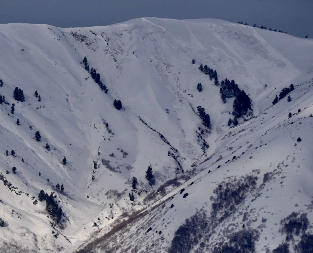
Several very large natural avalanches were observed with brief clearing on Thursday, the most notable in the Wellsvilles. Sizable natural avalanches were also visible in the Wood Camp and Steam Mill areas. Numerous avalanches can be seen on the drive up Logan Canyon.
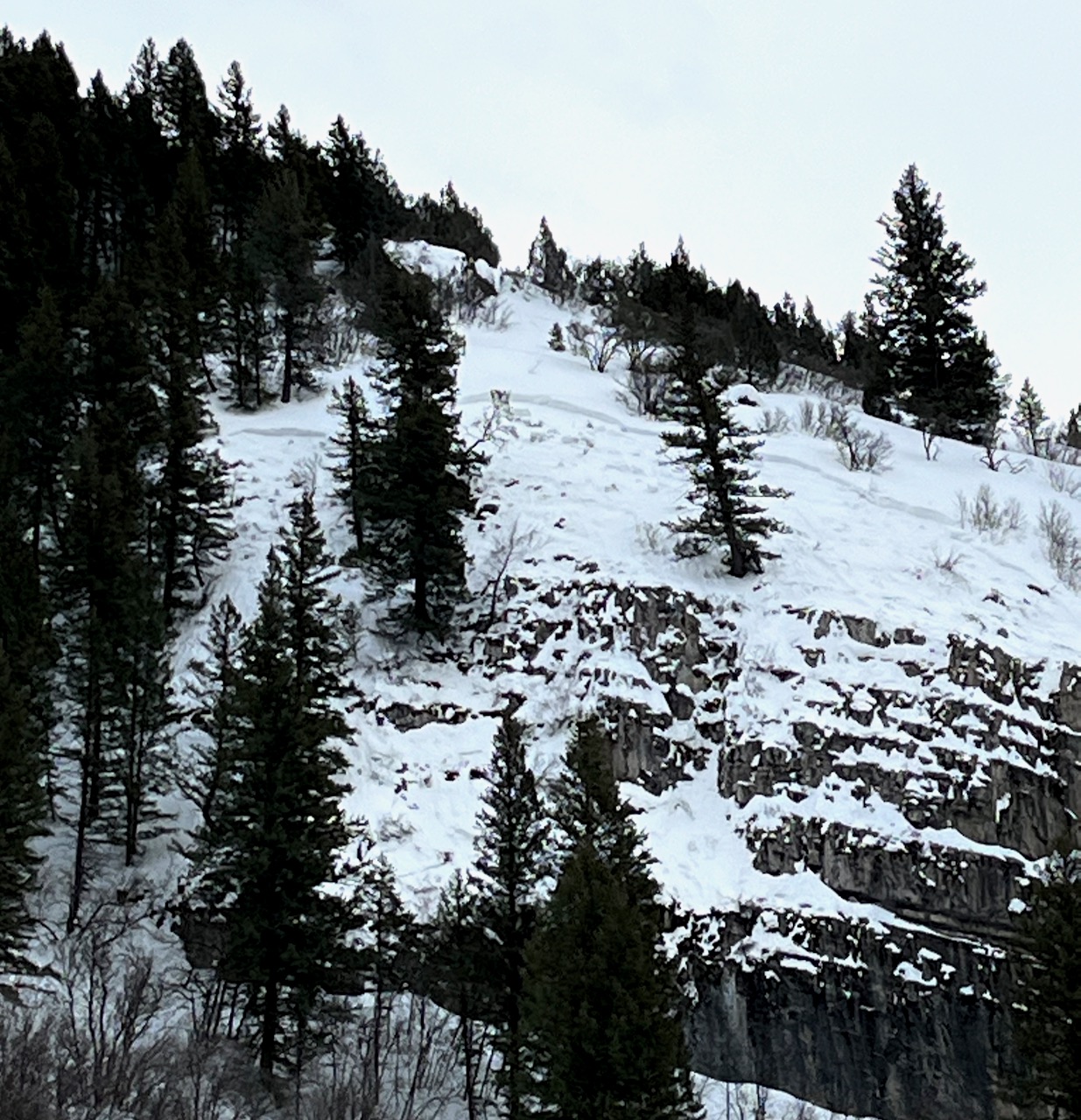
The Chicken Creek avalanche (near Logan Cave) occurred on 1/18/24.

Check out local observations and avalanches HERE.
Ad
Avalanche Problem #1
Persistent Weak Layer
Type
Location
Likelihood
Size
Description
Today, human-triggered slab avalanches failing on a buried persistent weak layer could be large and life-threatening. This past week, heavy snowfall and drifting by winds from the west overloaded slopes plagued by widespread buried layers of weak, sugary snow or facets and feathery surface hoar that developed during the prolonged December dry spell.
  • Avalanches could be triggered remotely, from a distance, or worse, from below!
  • Collapsing or whumpfs and shooting cracks indicate unstable snow.
  • Avalanches are possible even when there are no obvious signs of instability.

  • Exposed slopes, where the wind drifted the heavy new snow, developed dangerous wind slabs that now are overloading buried persistent weak layers. Watch for and avoid stiffer drifted snow on the lee side of prominent ridges and in and around terrain features like sub-ridges, gully walls, mid-slope rollovers, and cliff bands.
Additional Information
On Thursday, Toby looked at a remotely triggered avalanche low on Beaver Mt. Backside.

The Rattlesnake Canyon avalanche occurred on 1/18/24.

Dangerous roof avalanches are likely due to the mild temperatures. Be sure to keep children and pets out from under snow-covered roofs.
Always follow safe travel protocols on or under slopes steeper than 30°.
  • Be sure everyone in your party has working avalanche rescue equipment, including a transceiver, probe, and shovel. Practice with this equipment regularly, and include and instruct new partners.
  • Cross avalanche paths and runout zones one person at a time, with the rest of the party watching from a safe place.
  • Reevaluate and be willing to change your plans if you encounter any signs of instability, like recent avalanches, audible collapses (whumpfs), or cracking in drifted snow.
General Announcements
-For all questions on forecasts, education, Know Before You Go, events, online purchases, or fundraising: call 801-365-5522.
-To report an avalanche or submit an observation from the backcountry: go HERE.
-We will update this forecast by 7:30 AM tomorrow.
This forecast is from the U.S.D.A. Forest Service, which is solely responsible for its content. This forecast describes general avalanche conditions, and local variations always occur.