Forecast for the Logan Area Mountains

Issued by Toby Weed on
Wednesday morning, January 1, 2020
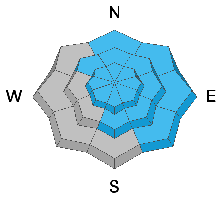
Heavy snowfall and strong westerly winds today will cause significant drifting and increasing CONSIDERABLE danger in the backcountry. Dangerous avalanche conditions will develop rapidly in many areas, and human triggered avalanches may become likely at all elevations. The danger could rise to HIGH in some areas tonight, with possible natural activity becoming more likely.
- Evaluate snow and terrain carefully. Use caution while route finding, and make conservative decisions.

Low
Moderate
Considerable
High
Extreme
Learn how to read the forecast here
Weather and Snow
It's 21°F at the 8400' Tony Grove Snotel this morning, and there's three inches of new snow. There is 47 inches of total snow, with 102% of average SWE for the date. It's 14°F on Logan Peak, and southwest winds are increasing, currently blowing around 36 mph with a 53 mph gust.
A potent Pacific winter storm will impact the area today with significant accumulations and strong west winds in the mountains. The avalanche danger will rise significantly, and dangerous conditions will develop on many slopes. Natural avalanches could become likely tonight.
The National Weather Service in SLC has issued a Winter Storm Warning for our area through today. It will be quite stormy in the mountains today, with 6 to 10 inches of accumulation possible, 8500' high temperatures around 24°F, west-southwest wind 18 to 25 mph, and wind chill values as low as -4°F. Snow will continue tonight, with 3 to 7 additional inches possible by morning. Expect low temperatures around 16°F, and it will be windy, with 21 to 31 mph west-northwest winds. Snow showers will continue tomorrow morning, with 1 to 3 additional inches possible. Expect high temperatures in the morning around 21°F falling to around 16°F during the day, and 11 to 16 mph west-northwest winds.
Recent Avalanches
A skier triggered a small soft slab of wind drifted snow Monday in the Mount Naomi Wilderness (5th Sister, Cottonwood) on a NE facing slope at about 9000'. The avalanche was reported to be about 10" deep x 25' wide.
Avalanche Problem #1
Wind Drifted Snow
Type

Location

Likelihood

Size

Description
Human triggered avalanches involving wind drifted snow are likely today. West winds increased overnight, 30 to 40 mph with gusts in the 50s, drifting fresh snow into avalanche starting zones. Expect significant drifting to continue during the day, and dangerous avalanches conditions to become more widespread.
- Even small avalanches can be quite dangerous in shallow snow conditions.
- Watch for and avoid stiffer drifted snow near ridge lines and in and around terrain features like cliff bands, scoops, gully walls, and sub-ridges.
Avalanche Problem #2
New Snow
Type

Location

Likelihood

Size

Description
Avalanches of new snow will become increasingly likely on steep slopes at all elevations as storm snow rapidly accumulates. Human triggered sluffs and soft slab avalanches will become likely in steep terrain by midday, and natural activity is possible especially during periods of particularly heavy snowfall.
Avalanche Problem #3
Persistent Weak Layer
Type

Location

Likelihood

Size

Description
The sugary October persistent weak layer near the ground on northerly facing upper elevation slopes appears to be dormant for now, but it could be reactivated in some places by today's new load of wind drifted snow. Dangerous hard slab avalanches could be triggered by smaller avalanches of wind drifted or new snow overrunning slopes with poor snow structure. It's always a good plan to avoid steep, thin, rocky terrain.
Some of today's avalanches might be triggered remotely, from a distance or below.
General Announcements
Thanks to the generous support of our Utah ski resorts and Ski Utah, we have discount lift tickets available. All proceeds from these go towards paying for avalanche forecasting and education! Get your tickets HERE.
EMAIL ADVISORY. If you would like to get the daily advisory by email you subscribe HERE.
Remember your information can save lives. If you see anything we should know about, please help us out by submitting snow and avalanche observations....HERE. You can also call us at 801-524-5304, email by clicking HERE, or include #utavy in your tweet or Instagram.
This forecast is from the USDA Forest Service, which is solely responsible for its content. The forecast describes general avalanche conditions and local variations always occur.
I will update this forecast before about 7:30 tomorrow morning.