
Drew Hardesty
Forecaster
Preface
As told by Derek DeBruin -
We’d been home just long enough to say hello to my wife and son and then unload the car from a few days of winter mixed climbing in Utah’s west desert. With both work and personal outings coming up in the next week, I was catching up on weather forecasts, the avalanche bulletin, and field observations. Standing in front of the fridge, I scrolled through a large list of avalanches in the central Wasatch for the previous day, January 5th. My climbing partner found the chips and salsa while I settled on an orange, sharing the occasional wedge with my son as I skimmed report after report of human-triggered wind slabs. Just as I began reading the one for “Blue Ice,” a text message buzzed my phone:
“In case you haven’t heard already, we were in a massive slide. We’re ok, but still wondering how/why we’re still alive. Scariest day of our lives. You can read all about it on the UAC page. It was in Broads Fork. Blue Ice, I think.”
I took a sharp breath, my heart pumping more forcefully. I exhaled and took a moment to calm, then read the whole report. I immediately made a call to my friend. We had a stilted conversation for a few brief moments.
“Well, if you need anything at all, please let me know…I’m glad you’re both okay,” I stammered.
“Yeah…thanks.”
“Of course, and I mean it.”
Silence. Neither of us knew what to say—we’d both been caught off guard.
Finally, I closed with, “Take care of yourself.” We hung up.
Some days later, I shared a beer with my friend to discuss the avalanche more completely. The conversation was candid and illuminating. A short time after, I would find myself taking a Professional Level 2 Avalanche course. A significant component of the course hinges on a technical report of an avalanche incident relevant to the student’s professional context. As my friend involved in the Blue Ice incident also works for me as a guide, I knew what I wanted to write about for my report.
The report that follows was compiled for a Professional Level 2 Avalanche course and reflects my understanding of the avalanches throughout the central Wasatch on 5 January 2019 based on publicly available avalanche reports through the Utah Avalanche Center website, weather data as recorded by various stations throughout the central Wasatch, the public avalanche forecasts and summative “week in review” blog posts issued by the UAC, and communication with involved parties in the Blue Ice avalanche. I’ve attempted to be as thorough and objective as possible despite my personal association with those involved.
FORECASTER COMMENTS: It should be noted that the party submitted an observation of the avalanche incident while in the emergency room that same afternoon. INFO.
Report by Derek DeBruin
Blue Ice Avalanche Accident Report
HS-ASu-R2-D2
2 skiers caught and partially buried Wasatch Range, UT
Big Cottonwood Canyon, Broads Fork 5 January 2019
2 skiers caught and partially buried Wasatch Range, UT
Big Cottonwood Canyon, Broads Fork 5 January 2019
SYNOPSIS
At approximately 10:00am on Saturday, 5 January 2019, two skiers were skinning uphill in Broads Fork of Big Cottonwood Canyon below the “Blue Ice” zone. Recognizing terrain steep enough to potentially avalanche and with evidence of recent wind loading, the skiers spread out, with Skier 1 approximately 75 feet above and ahead of Skier 2. Skier 1 triggered a hard slab avalanche which broke approximately 50 feet above and was caught and carried the remaining extent of the avalanche path (250 feet of a 300 foot path), partially buried to chest level. Skier 2 saw the slab break above Skier 1 and attempted to turn and travel the opposite direction but was also caught in the avalanche and carried a short distance. Skier 2 was partially buried head-down. Upon coming to rest in the debris, Skier 1 self- extricated and began the search for Skier 2, locating Skier 2 approximately 100 feet below the crown of the avalanche. Skier 1 extricated Skier 2 and isolated an airway for Skier 2, who was breathing but unconscious. Skier 2 remained unconscious for approximately 30 minutes. Upon Skier 2 regaining consciousness, both members of the party began a self-evacuation back to the trailhead, approximately 3 miles and 3,100 vertical feet distant. The party shortly met friends who had been skiing an adjacent zone, who assisted in travel to the trailhead and recovery of equipment as Skier 1 no longer had skis. Upon arrival at the trailhead, the party traveled to a local hospital emergency room for evaluation.
TERRAIN
The central Wasatch Mountains are located immediately adjacent to Salt Lake City, Utah, with a population of roughly 1.15 million. The central Wasatch “core” sees millions of visits each year, thanks in large part to its proximity to Salt Lake City and the 6 major developed ski resorts located in or adjacent to the core. In addition in-bounds skiing, the Wasatch core boasts “the greatest snow on Earth” in its numerous canyons, gulches, forks, and summits, resulting in hundreds of backcountry skiers, snowboarders, and other winter users visiting the canyon on any given weekend, many of them concentrated in Big and Little Cottonwood Canyons.
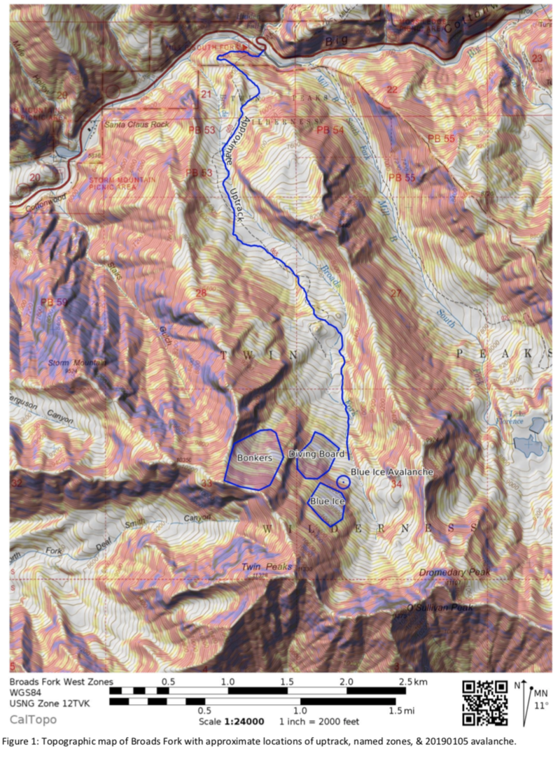
The Cottonwood Canyons are home to many peaks taller than 11,000 feet with an alpine zone generally starting between 9,500 to 10,000 feet. This incident occurred at approximately 9,400 feet in Broads Fork, which has a overall northerly orientation as the canyon opens into the larger Big Cottonwood Canyon (BCC). Broads Fork is typically accessed from the north via a trailhead in BCC using a skin track in the bottom of the canyon drainage. This track accesses the named ski zones in the upper reaches of Broads Fork after travel of some 3 miles and more than 3,000 vertical feet. The upper reaches of the canyon attain Twin Peaks, Sunrise Peak, and Dromedary Peak, major summits on the crest separating Big and Little Cottonwood Canyons with elevations in excess of 11,000 feet.
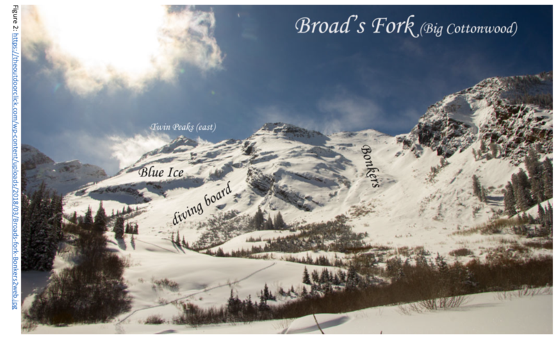
The Blue Ice zone is a northeast facing slope on the west side of Broads Fork near and above treeline at an elevation around 9,800 feet. Blue Ice is immediately adjacent to the “Diving Board” and “Bonkers”, both northeast facing zones to the northwest. There are large slabby cliffs throughout the area. Blue Ice is so named for a short vertical cliff nears its upper reaches that frequently forms ice flows. See map and photograph in Figures 1 and 2.
SNOWPACK & WEATHER
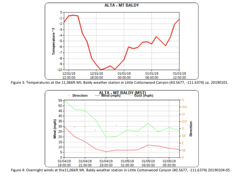
The 2018-2019 winter season in the Wasatch began with pockets of persistent facets on shady aspects at high elevations throughout the basal snowpack as a result of early season October and November snow events interrupted by long periods of dry weather. By the end of December 2018 avalanches on persistent weak layers, both basal and those associated with crusts, had largely subsided in the central Wasatch with a few notable exceptions in repeat slide paths or with significant loading. A storm the evening of Sunday, 30 December into Monday, 31 December 2018 delivered up to 16” of new snow, resulting in some avalanches due to wind loading that readily subsided. This storm was followed by cold, clear conditions from 1 to 3 January 2019, with temperatures as low as -10°F at the 11,000 foot ridgelines (see Figure 3). This resulted in a mix of surface hoar and near surface facets throughout the range, resulting in long running loose dry human-triggered avalanches and creating a potential weak surface for avalanches upon subsequent loading. Beginning late in the afternoon of 3 January 2019, winds shifted from the west to the south and finally to the southeast into the early morning hours of 5 January 2019 (see Figure 4).
With no recent new snow and moderate wind speeds at the ridgelines around 20mph (as low as 5mph the morning of 5 January), the avalanche forecast for 5 January 2019 reported a bottom-line hazard of “low” for all aspects and elevations (see Figure 5) and noted, “...Pockets of new and developing wind drifts may be found in isolated terrain. The danger may reach MODERATE in some areas later today...” The forecast noted “Normal Caution” as the only avalanche problem, but did offer some relevant details: “The snow is mostly stable. The mountains have seen a fair bit of wind over the past week or so and much of it blew from the northwest, and north through east. The current winds, however, are from the south and southwest and while there isn't that much snow to blow around, there is some [sic] and shallow drifts may be found in isolated terrain today...The last avalanches breaking into older snow layering likely occurred New Year's Eve during the wind event. These were in upper Hogum Fork of LCC on upper elevation northeasterly facing slopes...The Airplane Peak avalanches (roughly 2.5' deep and 80' wide) were in thin, rocky areas that have likely avalanched previously this season. Not unlike, say, the northeast face of Lone Peak, the Salt Lake Twins [emphasis added]....you get the idea.”
Of note in this accident are three key points. First, winds had largely traversed the entire compass rose following the most recent snowfall, resulting in difficult to predict wind loading. Second, the continually weakening surface snow increased the potential for snow transport due to wind, despite no additional snowfall. Third, avalanches had occurred in upper elevation, rocky, northeasterly terrain. Of particular salience is the forecaster’s mention of the Salt Lake Twin Peaks, which creates the headwall of Broads Fork and describes almost exactly the terrain that resulted in the Blue Ice avalanche.
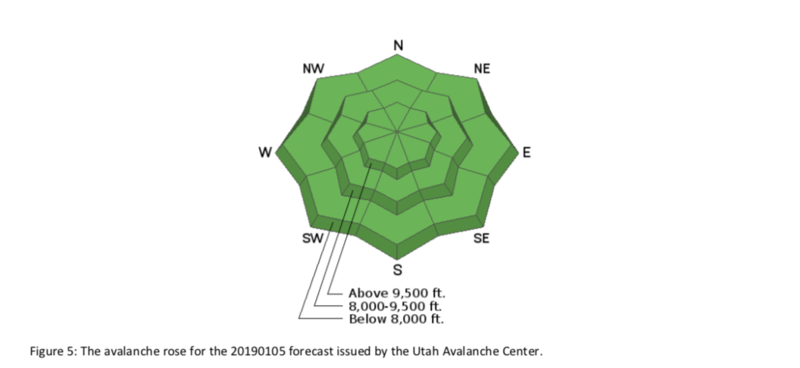
Figure 5: The avalanche rose for the 20190105 forecast issued by the Utah Avalanche Center.
AVALANCHE EVENT NARRATIVE
Skier 1 and Skier 2 planned a tour for Saturday, 5 January 2019 into Broads Fork of Big Cottonwood Canyon just east of Salt Lake City, Utah. In anticipation of stable conditions based on the “green light” forecast issued by the Utah Avalanche Center, they planned to tour into the upper reaches of Broads Fork to ski in the Blue Ice zone. Upon their arrival at the Broads Fork trailhead, they met a party of three of their friends who planned to ski the adjacent Diving Board and Bonkers. The two groups did not travel together, but they did anticipate potentially crossing paths throughout the day. Skiers 1 and 2 departed the trailhead and skinned up the standard Broads Fork approach, a summer trail/winter skin track that ascends the bottom of the Broads Fork drainage for roughly 3 miles and 3,100 vertical feet.
After this ascent, the pair was positioned near the base of the Diving Board zone, looking up into the Blue Ice zone to plan the best path to break trail. They noted active snow transport and wind loading on the crest ridgeline approximately 2,000 feet above. Anticipating potential wind affected snow, the party elected a conservative skin track keeping to the lowest angle terrain possible well below the short cliff that forms the vertical ice for which “Blue Ice” is named. Partway through the ascent, the party noted wind scouring and wind loading on the planned ascent route. Skier 1 and Skier 2 agreed to increase their separation on the skin track to approximately 50 to 75 feet. While breaking trail, Skier 1 alternately noted hard wind scoured snow and hard wind packed snow underfoot. When interviewed after the event, Skier 1 noted that differentiating between the two was difficult as both seemed of equal hardness and were beneath new surface snow (likely wind blown as no new snow had fallen in five days).
At approximately 10:00am while traversing a slope below the Blue Ice cliff, Skier 1 triggered an avalanche (HS-ASu-R2- D2) in hard wind slab on a northeast facing slope at approximately 9,400 feet of elevation (Figure 6). At the time of the avalanche, Skier 1 was approximately 75 feet above and ahead of Skier 2. Skier 2 reported that the crown of the avalanche formed approximately 50 feet above Skier 1. Skier 1 rapidly realized getting off the slab was not possible and began swimming, hoping to come to rest as soon as possible, but confident that Skier 2 would be a capable partner ready to provide rescue if needed. Skier 1 was carried the extent of the slide path (250 feet from the point where Skier 1 was caught) but did not suffer serious injury despite small to medium trees and shallow rocks in the path. Skier 1 was partially buried chest-deep in the debris.
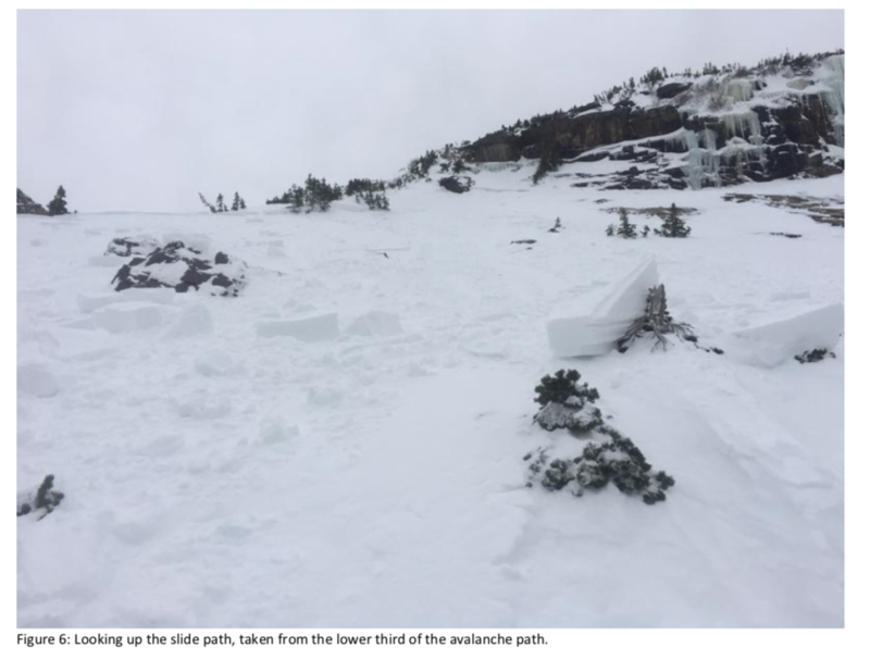
Figure 6: Looking up the slide path, taken from the lower third of the avalanche path.
Upon seeing the slab break above Skier 1, Skier 2 turned around to reverse the skin track as fast as possible to avoid being caught in the slide as the fracture propagated approximately 125 feet across the slope. Unfortunately, despite these efforts, Skier 2 was caught near the flank of the slide path, which knocked Skier 2 off their feet and onto their back. Skier 2 was impacted by several large chunks of wind slab which did not break further but also did not travel very far, perhaps 25 feet. Skier 2 slid downhill between two trees. These large chunks of snow came to rest against the trees on top of Skier 2. Skier 2 was partially buried head down on their back in a tree well and large chunks of debris pressing down from above. At least one of Skier 2’s skis was visible on the surface of the snow. See Figure 7.
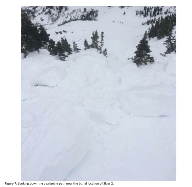
Figure 7: Looking down the avalanche path near the burial location of Skier 2.
Meanwhile, Skier 1 called out to Skier 2 to indicate Skier 1 was alright with head above the snow surface. After shouting several times with no response, Skier 1 concluded Skier 2 must have also been caught. Skier 1 worked to extricate themselves from the snow as rapidly as possible, no easy task owing to the chest-deep burial. Once on the snow surface, Skier 1 began post-holing up the bed surface to the crown of the avalanche to begin a signal search for Skier 2 using their transceivers. Skier 1 was hindered by a lack of skis which were lost in the avalanche. In the upper third of the slide path, Skier 1 identified the ski of Skier 2 sticking out of the snow surface near a tree. Skier 1 immediately began shoveling to extricate Skier 2. Skier 2 was found unconscious. Skier 1 established an airway and determined that Skier 2 was still breathing. Skier 1 finished extricating Skier 2 from the snow; Skier 2 eventually regained consciousness, approximately 30 minutes after the airway was established.
The pair continued their self-rescue by reversing their path to the main Broads Fork skin track to proceed to the trailhead. Without skis, Skier 1 was forced to travel on foot. Skier 2’s skis were both broken at the tip but largely intact and skiable with care. Near the main skin track in the bottom of Broads Fork, Skiers 1 and 2 met their three friends who had just finished skiing the adjacent Diving Board. The Diving Board party and Skiers 1 and 2 split into three groups. One
member of the Diving Board party accompanied Skier 2 to the trailhead on skis. The remaining two members of the Diving Board party returned to the avalanche site to look for Skier 1’s skis and any other equipment that had been lost (such as Skier 2’s helmet). Skier 1 proceeded on foot toward the trailhead and would likely be met by these two members of the Diving Board party later as they would be on skis and able to travel much more quickly than Skier 1. As Skier 2 had suffered a head injury and was burdened by broken skis, ski progress downcanyon was quite slow and all five individuals returned to the trailhead within a few minutes of each other. Skier 1 drove Skier 2 to the nearest hospital emergency room where they were immediately admitted, evaluated, and released.
Skier 1 initially appeared to have no major injuries, but at the time of writing Skier 1 reported an unspecified knee injury resulting in pain, swelling, and loss of mobility. Skier 1 is seeking follow-up care for evaluation, diagnosis, and physical therapy. Skier 2 reported symptoms compatible with concussion (headache, eye strain, etc.). Both Skier 1 and Skier 2 are expected to make a full recovery. They have since purchased new skis and spent a few days in-bounds at a local resort with plans to return to backcountry skiing when fit enough to do so.
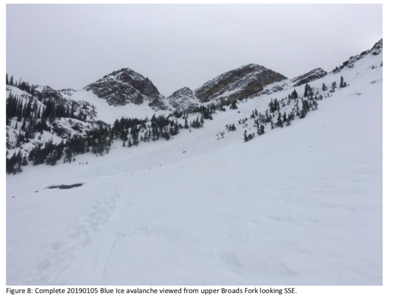
Figure 8: Complete 20190105 Blue Ice avalanche viewed from upper Broads Fork looking SSE.
DISCUSSION
This incident highlights a number of the factors related to humans traveling in avalanche terrain, from the perspective of the forecaster, Skiers 1 and 2 in particular, and forecast users in general. These include the difficulties both in creating a forecast and applying it in the field. This incident also highlights the value of consistent skills training.
Forecasting Challenges
Of particular concern to a forecaster is crafting a forecast that accurately evaluates the avalanche hazard for the forecast period and the forecast area (in this case one day and the central Wasatch, respectively). Frequent errors in assessment of the hazard can lead to end users abandoning the forecast altogether due to perceptions of the forecast as invalid and an inaccurate representation of the hazard in the field. If the forecast is consistently too conservative, users may perceive the forecast as inapplicable and be emboldened to engage with consequential terrain when it is inappropriate to do so given the actual hazard on site and their acceptable risk tolerance. Alternately, users may disbelieve the forecast when it does indeed accurately reflect the hazard because they feel that the hazard has been overrated in the past. Conversely, if the forecast is too aggressive, the avalanche hazard will be underrated and users may also engage with consequential terrain when it is inappropriate to do so. Thus, the avalanche forecaster has a relatively narrow acceptable operational band within which to situate the forecast (McClung 2011).
While the conceptual model of avalanche hazard provides a reasonable framework for developing a hazard rating based on spatial distribution, triggering sensitivity, and destructive size, such evaluations are estimations based on incomplete data and are inherently subjective (Statham et al. 2018). Consequently, the conceptual model can be limiting when probability and consequence must be distilled to a single word hazard rating based on the North American Public Avalanche Danger Scale (Statham et al. 2010). Any error in the estimation of spatial distribution, triggering sensitivity, or destructive size by even a single category (ex. whether the avalanche problem is “isolated” or “specific”) can change the “bottom line” hazard from one category to the next. More than one poor estimation can dramatically change the forecast’s hazard rating. Further, assessing the iterative predictive accuracy of forecaster’s (i.e. evaluating a forecast using a Brier score or similar) is uncommon and rarely feasible, which may in turn cause only loose coupling between a forecaster’s experience and their perceived confidence relative to their competence in issuing an accurate forecast (Tetlock & Gardner 2015). As a result, avalanche forecasts are not particularly robust instruments (Taleb 2012).
These criteria can be quite difficult to interpret from limited field observations and telemetric weather and snowpack data. While the forecast did note the possibility of hazard increasing to moderate throughout the day, the bottom line rating was low. The forecaster followed up with Skiers 1 and 2 after their near miss and stated that he “blew it” with the day’s forecast as a result. This was likely simply a result of the wind slab problem being more distributed or more reactive than the forecaster’s initial estimation, a challenge no doubt compounded by winds that were erratic in both intensity and prevailing direction as well as variable amounts of snow available for transport. Unfortunately, even in the Wasatch—which enjoys a large number of excellent professional field observations and an even greater number of amateur reports each day—we simply do not have the data or resources to remove the inherent uncertainty in avalanche forecasting.
Field Application of Forecasts
Despite the forecaster’s perception of underrating the forecast, Skiers 1 and 2 place no blame on the forecaster and assume full responsibility for their own decisions in the field. Skier 1 noted that they began the day with an “open season” mindset—a forecast with a low hazard rating meant “green light” conditions despite the warnings in the forecast for the very place they intended to travel that day (Atkins 2014). This by itself indicates potential complacency by this party. Further, commitment and social facilitation may both have played a role in the day (McCammon 2004). The pair was likely committed to skiing something (as opposed to abandoning the day’s tour entirely) given the relatively long approach up Broads Fork and the relatively few named zones in the area. Meeting friends at the trailhead unexpectedly may also have encouraged them to continue with their plan, particularly as the Diving Board party was skiing terrain that typically slides more frequently than Blue Ice. (In fact, the Diving Board likely avalanched overnight or the following day, not long after the party had skied it; the precise time of the Diving board avalanche is unknown.)
Despite these psychological factors working against them, the pair did note wind loading at the ridgeline and wind affected snow in the immediate vicinity. They elected the most conservative skin track possible for their chosen terrain
and also adjusted their spacing on the uptrack. Unfortunately, this was not enough to avoid an avalanche that caught both members of the party. The skin track used appears to traverse a slope with an angle less than 30 degrees as reflected by photographs and telemetric map data (though this was not measured on site). Regardless, three factors made the travel route ineffective at avoiding an avalanche and were immediately causal:
A faceted surface layer that had been growing for the preceding three days enhanced the possibility for significant propagation and remote triggering upon a new load.
The new snow loading atop this weak layer was comprised of very hard, fresh wind slab that was poorly bonded and capable of transferring energy across the top of the snowpack without the safety sometimes afforded by “bridged” hard slabs.
The terrain is known for relatively shallow snowpack with rocks and trees available as triggers points (as noted in the day’s avalanche forecast and visible in Figures 6 & 8).
Also significant were the number of other avalanches that day with similar precipitating factors. Eight additional avalanches were reported or can be inferred from publicly available reports to the Utah Avalanche Center (see Figures 9 & 10). This reinforces the idea that a low hazard rating led to complacency among backcountry travelers, particularly as wind affects are generally visible when in the field and therefore can be avoided in most situations with appropriate caution. Skiers 1 and 2 were not alone in their mis-estimation of the hazard presented to them in the mountains that day. Simply, current avalanche forecasting methods and their typically tightly coupled application by backcountry travelers do not create a particularly robust system. Given these linkages, risk management in the field demands more active input in the form of observations and updated decision-making as a result, particularly if backcountry travelers wish to enact plans that are not only robust (i.e. resistant to fragility), but actively anti-fragile.
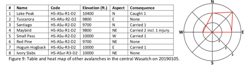
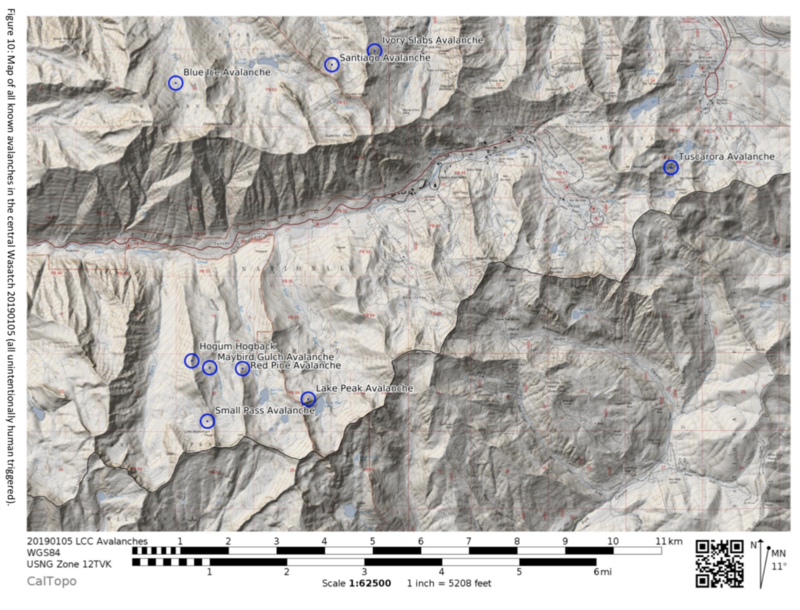
Figure 9: Table and heat map of other avalanches in the central Wasatch on 20190105.
Figure 10: Map of all known avalanches in the central Wasatch 20190105 (all unintentionally human triggered).
Skills Training
Despite the severity of the outcome in the Blue Ice avalanche, the relatively positive result certainly highlights the luck of Skiers 1 and 2, but also their skills training. Skier 1 has only been backcountry skiing for 4 seasons but has taken a level 1 course, an avalanche rescue course, is a member of Salt Lake County Search and Rescue, practices diligently each season. He is also a skilled climber and no stranger to the mountains in winter. Skier 2 is a long-time mountaineering instructor with Outward Bound, has also completed a level 1 course and rescue course, and occasionally guides backcountry skiing during the winter. While it is clear avalanches don’t care about expertise, Skiers 1 and 2 did make reasonable adjustments to their travel plan, short of abandoning the Blue Ice zone altogether.
Skier 1’s actions are also particularly commendable, and their mindset during and immediately following the avalanche may be helpful for others in similar situations. When interviewed about the incident Skier 1 noted rapid recognition that moving off the slab was impossible. Their subsequent response was to remain calm and begin “to think three steps ahead, like when you’re playing chess.” Skier 1 reportedly accepted that a ride in an avalanche was about to occur, fought to stay on top, and remained as calm as possible as the debris slowed, confidently trusting that “[redacted] will come dig me out, so just stay calm.” Skier 1 managed to maintain this levelheaded approach upon recognition of the partial burial. When it became apparent that Skier 2 was not responding to shouting, Skier 1 knew they must assume that Skier 2 had also been caught, carried, and buried and would need rescue. Skier 1 reported self-extricating while thinking the entire time about how they would need to switch their transceiver to receive and search the entire slide path, which would likely mean post-holing up the bed surface. While doing exactly this, Skier 1 maintained situational awareness adequate to identify Skier 2’s ski, isolate an airway, complete the extraction of Skier 2 from the snow, and stabilize Skier 2 until spontaneous regaining of consciousness. The fact that both members of the party then elected to continue self-rescuing and evacuation to the trailhead is laudable. Assistance from their friends nearby only reinforces the sense of duty by which all mountain travelers are bound to come to another’s aid.
Having just barely survived an avalanche, it is unlikely that Skier 1 would have performed so well at rescuing Skier 2 were it not for considerable personal and professional skills training and practice. High stress situations limit the ability to think critically, leaving rescuers heavily reliant on “system 1” processing (Kahneman 2011). History tells us that it is the rare case one rises to the occasion—all too often rescuers fall to their level of training and practice. Clearly, Skier 1 took these ideas to heart.
IMPLICATIONS FOR PRACTICE
Forecasting of any kind is a difficult endeavor. This is no less true in avalanche forecasting. For the mountain traveler, mountain weather forecasting has become so sophisticated with copious amounts of data and advanced weather models that it can be tempting to assume that avalanche forecasting is conducted in the same manner and with the same accuracy and precision. However, avalanche forecasts are considerably less certain, owing to limited and incomplete data and less powerful algorithms to apply to a similarly multivariate problem. Even in the case of weather, forecasts are often a subjective judgment based on the combination of multiple weather models. With so much complexity and uncertainty and so much at stake, the task of the forecaster is unenviable and made more stressful with the knowledge that forecast users of any kind will be applying the information provided to take risk. The forecast consumer must apply their own knowledge and judgment to the forecast as well as the conditions they perceive in the field in order to assume their own acceptable risk within the limits of their operational risk band.
Reducing the risk of travel through avalanche terrain is made all the more difficult owing to the Bayesian nature of current avalanche forecasting algorithms—such as the conceptual model of avalanche hazard—and their reliance on preceding observations, often detailed in AM/PM forms or other formal operational records. The avalanche forecast relies heavily on prior information about the snowpack and subsequent effects to the snow based on recent environmental conditions. Incomplete or inaccurate information necessarily creates greater uncertainty as the probability tree grows increasingly forked. Indeed, this is why an "assessment" mindset is applied when little is known about the current snowpack, its attendant stability, or recent weather effects on the snow. Vigilantly maintaining an assessment mindset at all times regardless of prior knowledge is likely one of the best defenses against "black swan" avalanche conditions; that is, unusual and/or unexpected conditions that do not fit with prior knowledge, the resulting forecast, and assumptions about how these interact with the terrain and snowpack in front of travelers in the field. The savvy backcountry traveler would do well to remember that even when starting from solid prior knowledge (i.e. reading observations and forecasts daily, or better yet, being in the field daily), such prior knowledge may not apply in different zones, nor does it necessarily account for what happened overnight. Simply put, even on "green light" days, observations should be taken regularly and used to challenge the forecast and planned travel route.
In the case of the Blue Ice avalanche and other human triggered avalanches of 5 January 2019 in the central Wasatch, the old adage that, "Low hazard doesn't mean no hazard," applies. Ideally, a group's "normal caution" includes consistent pertinent observations throughout backcountry travel with the expressed aim of disproving or disconfirming the current travel plan and its assumptions about the snowpack and terrain. However, simply making observations is insufficient—observations must be translated into meaningful action, as the Blue Ice event demonstrates. While the party recognized signs of increasing wind slab hazard, they failed to act in a manner that eliminated the risk of avalanche. This is made all the more compelling because they did indeed take proactive action, but the action did not match what the conditions demanded to prevent a slide. In such cases where the only effective mitigation strategy is avoidance, multiple plans are advised. With multiple plans, an implicit commitment heuristic might be avoided by naming plans not as “Plan A, B, C...” or “Plan 1, 2, 3” but rather by aspect, elevation, angle or other factors directly relevant to the hazard (ex. a “solar plan” and a “shady plan”).
Finally, there is no substitute for practice, whether in planning, slope angle assessment, digging pits, or rescue skills. When the moment comes to search efficiently and shovel hard and fast to uncover a partner buried in avalanche debris, these skills will be far more timely and effective if they come from “system 1” thinking. That is, they should be well- practiced and automatic. In highly stressful situations, as time-sensitive life threats often are, system 1 tends to be the default. However, system 2 thinking is very useful for planning for crucial next steps during a rescue and maintaining situational awareness of surface clues, hazardous environmental conditions, etc. When rescue skills are practiced to the point of rote recitation without compromising effectiveness (i.e. system 1), this frees mental bandwidth for crucial system 2 thinking, increasing the effectiveness of the rescuer and chances for a positive outcome.
CORRESPONDING AUTHOR
Derek DeBruin
REFERENCES
Atkins, R. (2014). Yin, Yang, and You. 2014 International Snow Science Workshop Proceedings.
Kahneman, D. (2011). Thinking, Fast and Slow. New York: Farrar, Straus, and Giroux.
McCammon, I. (2004). Heuristic Traps in Recreational Avalanche Accidents: Evidence and Implications. Avalanche News, 68.
McClung, D. M. (2011). The Strength and Weight of Evidence in Backcountry Avalanche Forecasting. Natural Hazards, 59, 1635-1645.
Statham, G., Haegeli, P., Greene, E., Birkeland, K., Isrealson, C., Tremper, B., . . . Kelly, J. (2010). The North American Public Avalanche Danger Scale. 2010 International Snow Science Workshop Proceedings.
Statham, G., Haegeli, P., Greene, E., Birkeland, K., Isrealson, C., Tremper, B., . . . Kelly, J. (2018). A Conceptual Model of Avalanche Hazard. Natural Hazards, 90, 663-691.
Taleb, N. N. (2012). Antifragile: Things That Gain From Disorder. New York: Penguin Random House.
Tetlock, P.E., & Gardner, D. (2015) Superforecasting: The Art and Science of Prediction. New York: Crown Publishing Group.
An outdoor educator and guide for more than a decade, Derek DeBruin owns Bear House Mountain Guiding with his wife Susan, which offers climbing and skiing instruction throughout the Wasatch. Derek also teaches courses at Weber State University. He serves on the Diversity, Equity, and Inclusion committee for the American Mountain Guides Association and volunteers for the Weber County Search and Rescue team.
Derek prefers an interdisciplinary approach to most things, including mountain travel, employing skis as often as crampons during the winter months. You can find Derek on Facebook at https://www.facebook.com/dmdebruin and on Instagram @derekmdebruin. His recent research on climbing belay systems is available below: http://staff.weber.edu/derekdebruin/fixedpointbelay/Comparison%20of%20Fall%20Forces%20between%20Fixed-Point%20and%20Redirected%20Belays%20in%20Recreational%20Climbing%20Systems.pdf
You can find Bear House Mountain Guiding online at http://bearhousemountainguiding.com/ or on Facebook at https://www.facebook.com/BearHouseMountainGuiding/


