

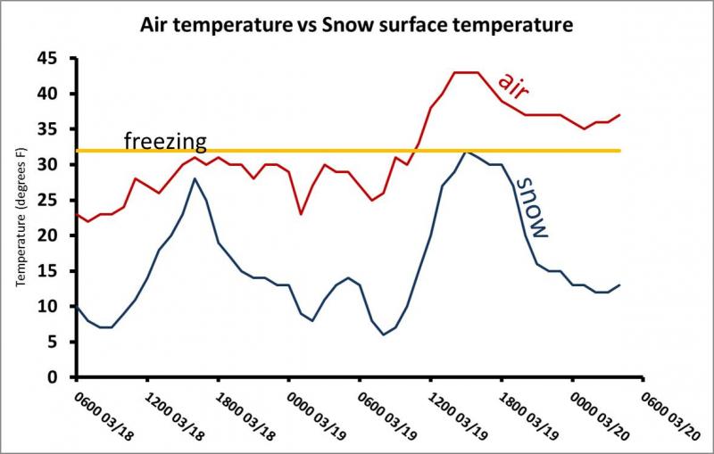
Ever wonder how the snow on north aspects can stay cold and dry during such warm weather? There is a big difference between air temperature and snow surface temperature. This is why the snow can refreeze even on relatively warm nights if the skies are clear. Snow loses heat very efficiently to clear skies at night then warms during the day as air temperatures warm. See the graph below showing air temperature vs snow temperature along Bunnells Ridge (8800') just south of Provo Canyon during the last 2 days. Notice that snow temperatures at night got as low as 6 degrees F then warmed to 32 degrees briefly yesterday before cooling again last night.
Why is this stuff important? It can improve riding conditions but it can also create weak layers.
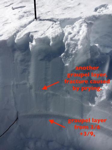
These temperature flucuations cause faceting (weakening) of the snow surface. Guides yesterday noted some faceting on the snow surface which improved riding conditions because the snow crystals lose cohesion. This process occurred over a weak ago and formed a few different weak layers now buried 1-1.5 feet deep. These layers include some weak graupel and some weak faceted snow. Evelyn found these layers yesterday in Cardiff Fork where a natural avalanche occurred on Wednesday.
These weak layers are present on many slopes but are not a problem at the moment because they don't have enough weight on them to stress them and cause avalanches. However during the last few days there have been some avalanches on these layers where the additional weight of wind blown snow tipped the scales. With more snow coming next week, we'll keep an eye on these layers to see if the weight of new snow stresses these layers enough to cause avalanches. With the recent sunshine and heat, these layers should only remain an issue on NW, N and NE facing slopes. Read Evelyn's thoughts on the distribution off these layers below:
The discussion below is copied from Evelyn's observations yesterday in Cardiff Fork.
A return to "winter" and storms this month, with dry spells, havegiven us a layered upper snow pack. The layers of concern are fairly limited, mostly to northerly and northeasterlyupper elevation slopes The snow on most other slopes isstabilizing -warm temperatures and strong sun are creating melt-freeze layers on all other aspects and elevations, that will be strong when frozen. I think in most places, these weaker layers don't have enough of a load for slides to break down into them yet, but they could continue to weaken and/or get overloaded with the next storm. There are 3 "funky" layers I've been seeing -
- re-crystallizedgraupel, from the 2 storms around March 6th and March 9th.
- a very localized layer of near surface facets
- Crusts with facets beneath them
Below is a very rough aspect/elevation rose of where I think some of these weak layers may be found. It's going to be worth keeping an eye on this upper layering, especially ahead of the next storm.


