Observer Name
UAC Staff
Observation Date
Thursday, May 9, 2024
Avalanche Date
Thursday, May 9, 2024
Region
Salt Lake » Big Willow
Location Name or Route
Big Willow Aprons
Elevation
10,600'
Aspect
North
Slope Angle
40°
Trigger
Skier
Trigger: additional info
Unintentionally Triggered
Avalanche Type
Soft Slab
Avalanche Problem
Wind Drifted Snow
Weak Layer
Density Change
Depth
18"
Width
150'
Vertical
800'
Caught
3
Carried
3
Buried - Partly
1
Buried - Fully
2
Injured
1
Killed
2
Accident and Rescue Summary
On Thursday, May 9, 2024, Austin Mallet, 32, and Andrew Cameron, 22, died in an avalanche in the Big Willow drainage of the Wasatch Mountains. On that day around 5:00 AM, they began hiking with a friend, 23, up the Sawmill trail to access the Big Willow Drainage. They intended to use the Big Willow Aprons as an approach to Lone Peak. Earlier that morning, they left a car parked in Little Cottonwood Canyon near the Y Couloir which they planned to ski as a final run at the end of the day. Their tour was on the heels of a significant, late season storm that left up to two feet of new snow in the mountains between Sunday and Tuesday. Their friend had skied with Andrew on Monday. He also skied on Tuesday, and Wednesday in Little Cottonwood Canyon. His assessment was that the snowpack seemed to be stabilizing, particularly by Wednesday.
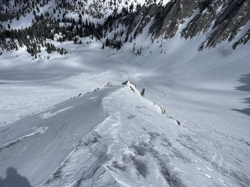
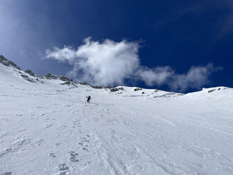
The group of three started hiking in running shoes for about 2 miles then switched to skis when they got to the snow. By around 8:30 AM, they had reached the bottom of Big Willow Cirque where the friend joined a work meeting on his phone. Austin and Andrew continued breaking trail ahead. After his meeting, the friend caught up to his partners and they ascended together. They skinned as far as they could and eventually began to boot pack (hike on foot) approximately 150’ vertical below the ridge. The friend took the boot pack lead and began “wallowing” in deep snow up the slope. The old snow was still soft, and he remembers not feeling any supportable layer under the new snow. He noticed a very thin wind-affected layer on the surface of the snow, but no indications of wind loading (past or current) or other obvious signs of instability. They were moving diagonally up the slope about 100’ vertical below the ridge, and the friend crossed to the looker’s right side of the fin (locations marked in the photo below). At 9:44 AM (according to his GPS watch*), he took 4-5 more steps, and the avalanche broke above and around him.
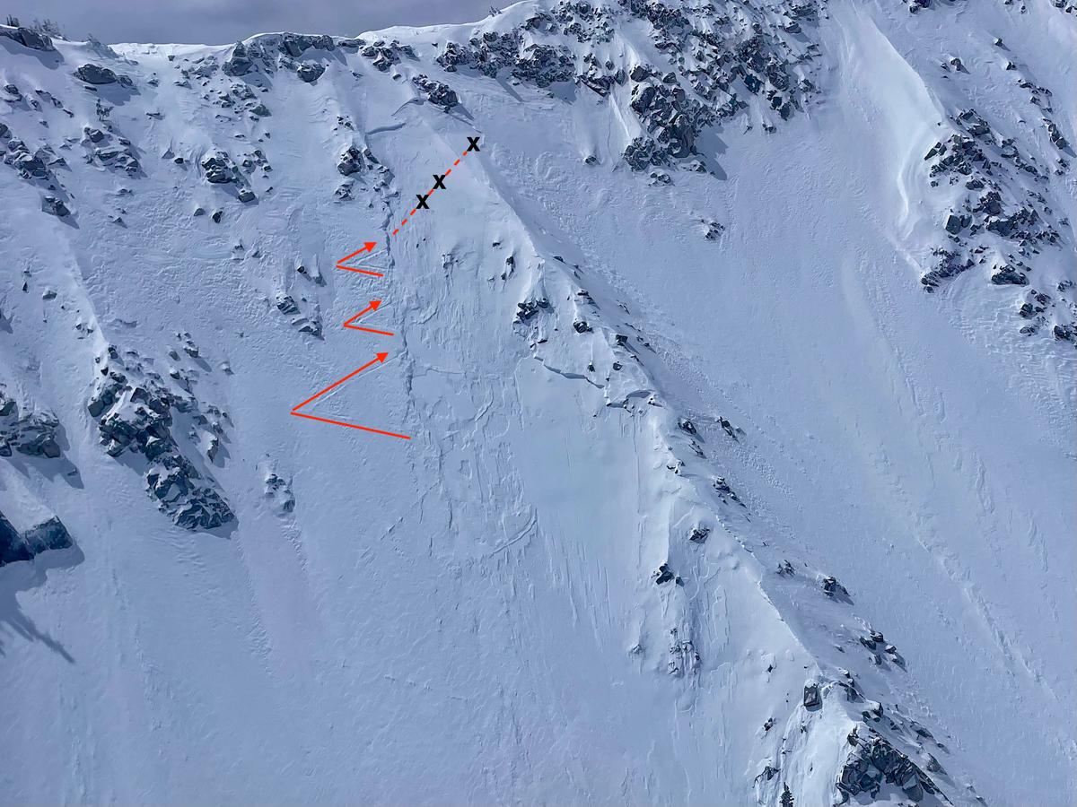
Photo above - The fin on Big Willow Aprons. The X's mark the skiers' positions just before the avalanche.
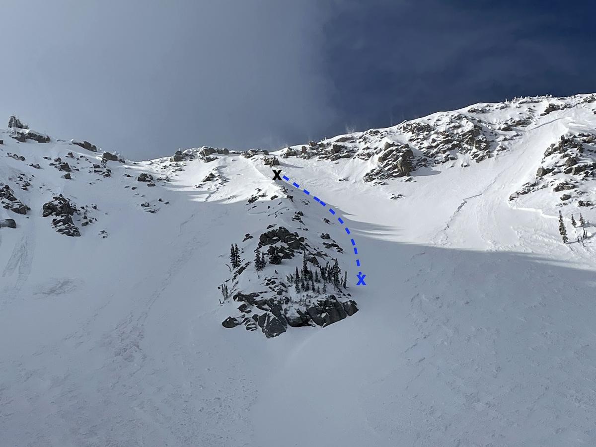
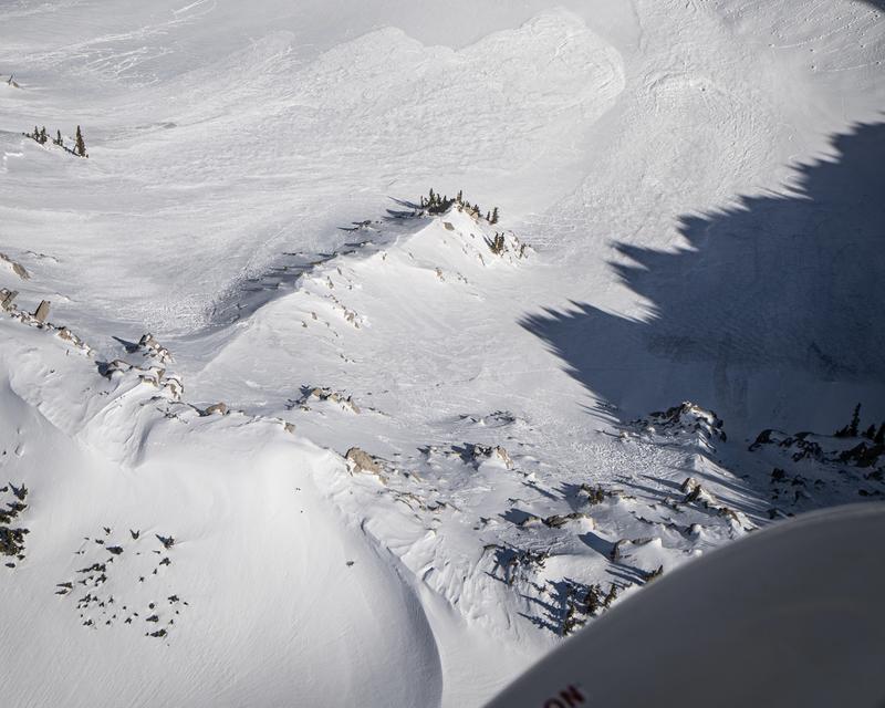
Photo above - The blue X marks the approximate spot the friend stopped on the slope. There are other avalanches and bomb holes from post-accident mitigation work visible in the photo.
The friend was knocked off his feet and tumbled head over heels, cartwheeling down the slope, for approximately 300 vertical feet. When the snow stopped moving, he was sitting upright, partially buried with his right arm free and left arm covered in snow. He took off his glasses because he couldn’t see, coughed up snow, and dug himself out. At the time, he thought he was the only one caught and believed Austin and Andrew were waiting for him on the other side of the fin (looker’s left). He skied down to the bottom of the fin, turned around the base, and saw the other side (looker’s left) had avalanched even bigger.
He immediately yelled for his partners and turned his transceiver to receive. He did not have a signal until he skied down within transmitting range of his friends’ transceivers. After acquiring a signal, he noticed a ski on top of the avalanche debris and moved towards it. About 13 minutes (according to his GPS watch*) after the avalanche occurred, he probed and struck Austin on the second try. He partially dug Austin out, gave a few rescue breaths, but got no response. He cleared more snow away from Austin’s chest, hoping he would spontaneously start to breathe. He then turned his focus to finding Andrew, who was still buried.
The friend hit the flag button on his transceiver to silence Austin’s signal so he could hear Andrew’s. He was confused for 1-2 minutes because his transceiver displayed a strong signal 44m away from him. This distance reading didn’t make sense because some of Austin and Andrew’s gear was visible on the slope near him, but he initially moved away following the directions on his transceiver. However, the readings on his transceiver steered him back towards Austin. He flagged Austin’s signal again, acquired Andrew’s signal which was nearby, and started a fine search. As he started this search, he noticed a glove poking through the snow. He dug near the glove but didn’t find anything so he performed a fine search again. He probed twice and found Andrew. He uncovered his head, cleared his airway, and performed rescue breaths, but Andrew did not start breathing. He called 911 at 10:18 AM, and continued to unbury his partners while waiting for help to arrive, but stopped, as he believed they were dead.
*Times are from the friend’s GPS watch, giving us a reasonably accurate timeline, but there was a flaw in the data the moment the avalanche occurred.
Rescue and Recovery Operations
About 1-1.5 hours after the avalanche, an air ambulance helicopter flew to the scene for a recon flight but had to circle the area due to cloud cover and poor visibility. The clouds parted just long enough to photograph the area and quickly evacuate the friend with a hoist mechanism. He was subsequently transported via ground ambulance to a hospital for evaluation. Winds and clouds were increasing, and visibility for safe flying was decreasing.
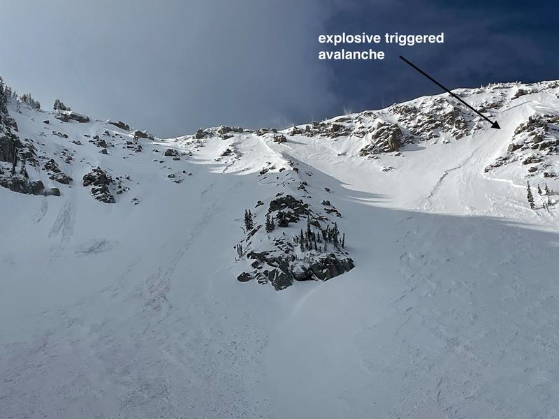
Before more rescuers could be safely inserted into the area, additional avalanche hazard needed to be mitigated with explosives dropped from a helicopter, but poor weather delayed this operation for about 30 minutes after the initial recon flight. Even after launching, the helicopter had to circle the area several times before visibility improved enough for the snow safety team to deploy explosives. They triggered another avalanche just west or looker’s right of the original slide.
After mitigation work was completed, deteriorating weather and poor visibility made subsequent helicopter operations unsafe, and recovery operations were halted for the day at about 4:30 PM. Operations resumed at 6:00 AM on Friday, May 10. Rescue personnel performed another recon flight to assess the accident site and surrounding slopes. They determined the scene was safe, and Search and Rescue personnel were transported to the site by helicopter. They dug out Austin and Andrew (they were buried approximately 2-3 feet deep) and brought them down to the Incident Command post via helicopter around 9:20 AM. The entire operation was complete by about 11:00 AM.
Terrain Summary
Big Willow Aprons is a north-facing slope (20° azimuth) at the head of the Big Willow drainage with elevations ranging from 9,700 to 10,670 ft. It is rocky near the top and slope angles average 40° in steepness. On the day of the accident there were no large cornices overhanging the slope. Overall, Big Willow Aprons is a concave slope with a clean runout, divided in the middle by a fin of rock that ends about half of the way down the slope.
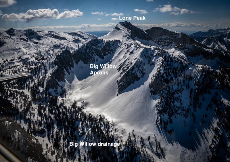
Aerial photo of the Big Willow drainage and Lone Peak - K. Barney
Avalanche crown face: 10,600 ft
Toe of avalanche debris: 9,747 ft
Full burial locations (about 15 ft apart): 9,880 ft, 40.53246, -111.76147
Partial burial location: 10,200 ft
Runout angle of debris: 30°
Avalanche classification: SS-AFu-D2-R2-I (Soft slab, artificially triggered by people on foot, unintentionally, large enough to bury a person, and a small avalanche relative to the path.)
There are two other avalanches of note:
1. On the day of the avalanche, another very similar avalanche in Bells Canyon caught and carried one skier. It happened just over an hour after the Big Willow avalanche about 1.3 miles to the northeast on a north-facing slope at 10,400 ft. https://utahavalanchecenter.org/avalanche/87487
2. Five years ago in April 2019, a very similar avalanche on the same slope caught a skier while they were descending. https://utahavalanchecenter.org/avalanche/47192
Photos below:
1. and 2. Topographic maps that show the approximate location of the avalanche in red.
3. View from the top of the fin.
4. View of the initial avalanche prior to avalanche hazard mitigation work.


Weather Conditions and History
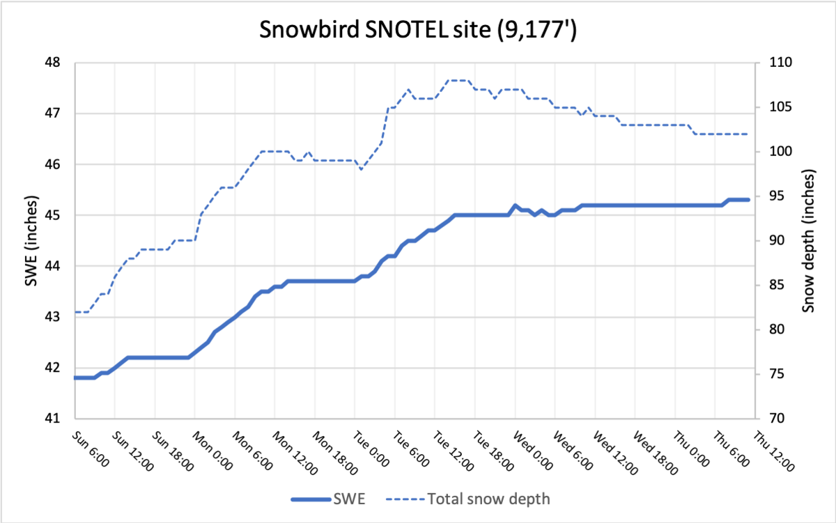
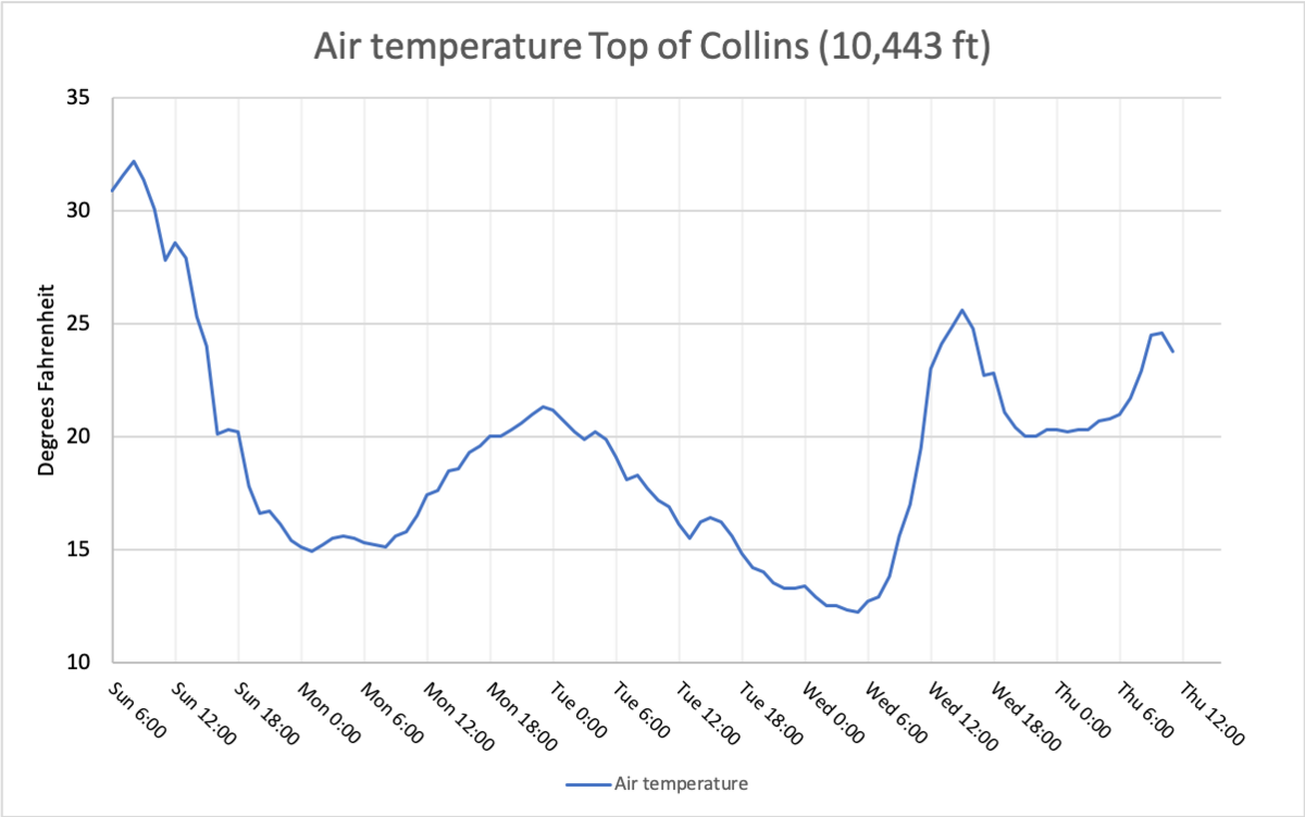
A major winter storm arrived on Sunday morning, May 5. Temperatures plummeted that first day at upper elevations from around 30° to 15° F. By Tuesday evening (~60 hours later), the storm had delivered snow containing 3.4 inches of water with settled new snow depths of 20-24 inches. There was negligible snowfall after Tuesday evening.
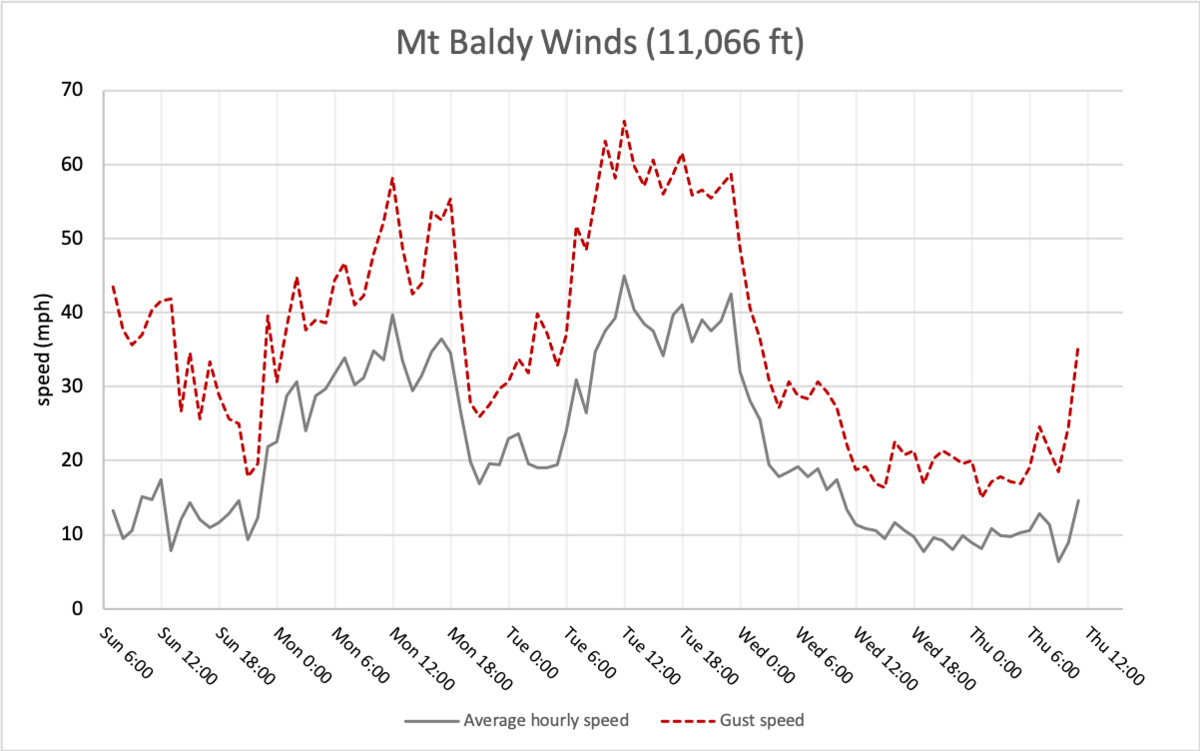
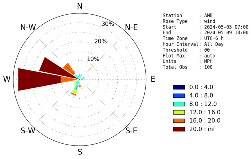
Very strong winds blew during the day Monday and Tuesday averaging 30-40 mph, and gusting 50-60 mph mostly from the west. The still open Snowbird Ski Resort was unable to operate the tram due to wind speeds of up to 80 mph. Automated wind stations at upper elevations in both Big and Little Cottonwood Canyons reported strong winds from variable directions but some locations reported sustained westerly winds.
We believe strong winds were a factor in this avalanche. Winds generally from the west would have blown across the cirque and cross-loaded the fin feature. An aerial photo of the ridgetop above the avalanche does not show evidence of top loading. During our visit to the site, we did not observe any major deposits of wind-blown snow or deep drifts, and we suspect wind effects were more subtle in their contribution to this avalanche.
View of the ridgetop above the avalanche showing no evidence of top loading from winds onto the slope that avalanched. ( K. Barney)
The day after the accident, we measured 18 inches of settled new snow in a wind-sheltered location just below the avalanche.
We measured 20 inches of settled new snow in the flank of the avalanche where it was likely wind-loaded to some degree.
Weather data in the graphs below were taken from the following:
Snowbird SNOTEL site for precip, el. 9,177 (5.6 miles WSW from the avalanche).
Mt Baldy for winds, el. 11,066 ft (7 miles WSW from the avalanche).
Wind Rose from Mt Baldy showing the distribution of wind direction from May 5 to May 9 (courtesy of MesoWest and Brian Blaylock).
Top of Collins for air temperature, el. 10,443 ft (7.4 miles WSW from the avalanche).
Snow Profile Comments
Given the area over which this avalanche fractured and the subtle wind effects observed at the scene and reported by the survivor, we are not sure of the exact character of this avalanche. Strong winds likely played some role in forming a slightly more cohesive slab on the leeward side of the rocky rib or fin, but it was not very obvious.
We are unsure what the weak layer was in this avalanche. In many places, the old snow surface (prior to the storm that started Sunday, May 5) was hard, icy, and dirty. What was notable about this avalanche was that the old snow surface in the starting zone only had a very thin and fragile ice crust. Being a high-elevation, north-facing slope, it is conceivable that a very thin layer of snow on top of this crust could have weakened and faceted to some degree. There were also numerous layers in the storm snow, but all had the same hand hardness or density. The only safe places to examine the snow were in one part of the flank of the avalanche and an area at the bottom of the cirque. We did not see any evidence of faceted crystals in these locations, but we can’t rule them out because strong sunshine and warm air temperatures were melting the snow on our crystal card before we could examine it closely.

Comments
The Salt Lake area forecast was updated for the last time on May 1 with general reminders about traveling on snow in the spring as well as specific information about wet snow, new snow, and wind-drifted snow avalanche problems.
We aim to learn from all avalanche accidents and offer comments to help others avoid future accidents. All of us at the Utah Avalanche Center have had our own close calls and know how easy it is to make mistakes. Our intention is for this report to offer a learning opportunity. For that reason, we have the following comments.
- Exposing one person at a time in avalanche terrain is one of the fundamental “rules” of safe travel. However, many skiers ascend avalanche terrain at the same time when they believe conditions are stable, more commonly in the spring. At times, this may be appropriate given many factors, but it means a higher level of risk and requires a higher level of confidence in stability.
- Close proximity burials can be especially challenging in a transceiver search due to the signal overlap of the nearby transceivers. Multiple burials are challenging regardless and can significantly reduce the odds of survival. There are search techniques to deal with burials in close proximity.
- Electronic devices like GPS watches, phones, GoPros, etc. can interfere with transceiver use. It doesn’t appear that interference was a factor in this accident. The current solution is a 50 cm (20 in) separation between the device and the searching transceiver. Wearable devices like watches or heated gloves can be problematic because it is difficult to get separation. Holding a transceiver in the other hand or removing heated gloves are solutions, but these actions could be difficult to remember during a stressful situation.
- The friend commented that he was frustrated with his smaller shovel size and would recommend a larger shovel which can move significantly more snow faster.
- The three skiers were all strong, experienced mountain athletes. Despite their skillsets, sometimes accidents happen with tragic outcomes. Mountain travel is inherently dangerous and even the best of us can find ourselves in trouble.
The Utah Avalanche Center would like to express our appreciation to the friend of the victims for sharing his experience in great detail during such a difficult time. His input has been invaluable in helping us understand the events that led to this tragic accident. As with all avalanche accidents, we all hope to learn something so that future accidents may be prevented. Our deepest condolences go out to the friends, family, rescuers, and everyone affected by the accident.
Participating agencies: Wasatch Backcountry Rescue, Salt Lake County Search and Rescue, the Utah Department of Public Safety, Unified Police Department, Draper Police, Salt Lake County Sheriff, LifeFlight, and others.
Photos below:
1. View to the northwest from the crown area.
2. Aerial view showing the close proximity of the burial locations (K. Barney)


Comments
Photos below:
1. The group's tracks approaching the Big Willow Cirque as seen the following day.
2. Hiking up the bed surface of the avalanche the following day.

Comments
To help honor his life, Andrew’s family has asked for donations to support the Utah Avalanche Center in lieu of flowers. Click here to donate.
Andrew Cameron
December 26, 2001 - May 9, 2024
Coordinates


