
Forecast for the Uintas Area Mountains

Issued by Craig Gordon for
Tuesday, November 22, 2016
Tuesday, November 22, 2016
Until the season really gets rolling, I'll update this information as storms start to develop or if conditions change rapidly. The next advisory update will be Wednesday, November 23rd. In the meantime, while you're waiting for snow to stack up, please let us know what you're seeing. You can reach me at [email protected]
Also, before life gets crazy busy, consider scheduling one of our free avalanche awareness presentations (contact me at [email protected]) or sign up for our ever-popular, sled specific Avy Awareness and Riding Skills Workshop. (Click here for more details)
Whole foods event:
Between now and Jan 15th: Donate to the Utah Avalanche Center by shopping at Whole Foods Market Utah! when you visit Whole Foods Market Trolley Square, Sugarhouse & Cottonwood Heights locations and bring in your re-usable bags, Whole Foods will donate a dime per bag to Utah Avalanche Center when the cashier asks if you want to “keep or donate” your bag credit and you say “DONATE".
A nice shot of snow developed over the eastern front late yesterday afternoon, delivering 6"-8" of dense snow... just what we needed! Temperatures cooled around dinner time and are currently in the mid 20's. It's still super shallow out there and with only about 10" of total snow on the ground, there's hardly enough to recreate on just yet.
Ted was out and about Saturday and submitted his trip report along with a nice video overview of current conditions... found here.
Real time wind, snow, and temperatures for the Uinta's are found here.

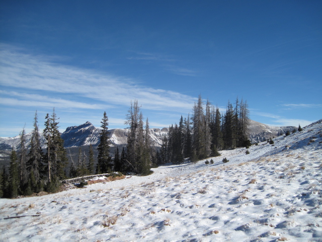
Not much snow, even on the high elevation slopes near Bald Mountain Pass. Ted Scroggin photo.
No new avalanche activity to report

Since last Thursday the Uinta's have picked up just over a foot of medium density snow. We're off to a good start and there's very little, weak, sugary snow on the ground to contend with. Of course, that can all change and we'll keep you updated as the early season starts to unfold, but right now, things are looking positive.

Shallow snowpack, but not much weak sugary snow near the ground. Ted Scroggin photo.
We might see a lingering snow shower or two, but in general yesterday's storm is done with us and moving east. Clouds thin out as the day progresses, winds will be light and northerly, and high temperatures reach into the mid 30's with overnight lows in the upper 20's. Winds ramp up, clouds thicken, and a good shot of snow develops late tomorrow afternoon, lingering into Thanksgiving morning with an additional 6"-10" of snow stacking up.
Remember your information can save lives. If you see anything we should know about, please participate in the creation of our own community avalanche advisory by submitting snow and avalanche conditions. You can call me directly at 801-231-2170, email [email protected]
The information in this advisory is from the US Forest Service which is solely responsible for its content. This advisory describes general avalanche conditions and local variations always occur.
The information in this advisory expires 24 hours after the date and time posted, but will be updated on Wednesday November 23rd with general avalanche information.