Observation Date
12/24/2017
Observer Name
CBrown
Region
Salt Lake » Park City Ridgeline
Location Name or Route
Park City Ridgeline
Weather
Sky
Broken
Wind Direction
West
Wind Speed
Light
Weather Comments
Day started with few clouds lots of blue skies and quickly had the high clouds move in in front of the next system. Winds on the ridgeline were not as high as anticipated and I wasn't seeing much snow transport. Very cold temps in the negative single digits down low this morning, felt slightly warmer up at about 9,500'. Temps warmed quickly through the morning.
Snow Characteristics
New Snow Depth
16"
New Snow Density
Medium
Snow Surface Conditions
Powder
Snow Characteristics Comments
Seemed to be about 14"-18" of new snow, including the light density snow from the Wednesday/Thursday storm, probably in the 12" range from just Friday's storm. Seemed to be a few density changes in the new storm snow from yesterday. Even protected areas had an upside down feel to it.
Red Flags
Red Flags
Recent Avalanches
Cracking
Collapsing
Poor Snowpack Structure
Red Flags Comments
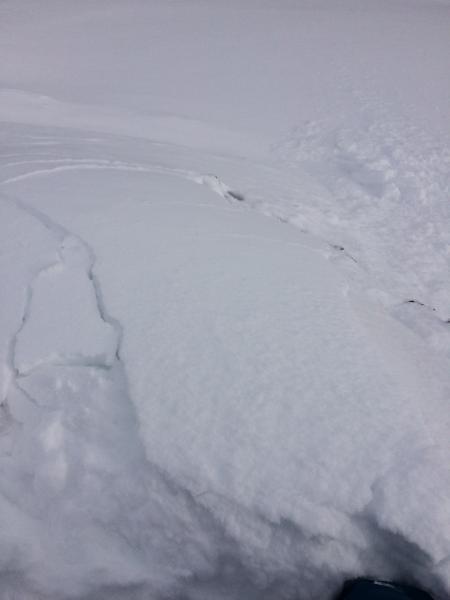
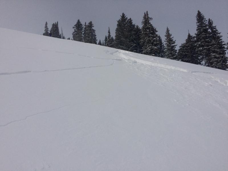
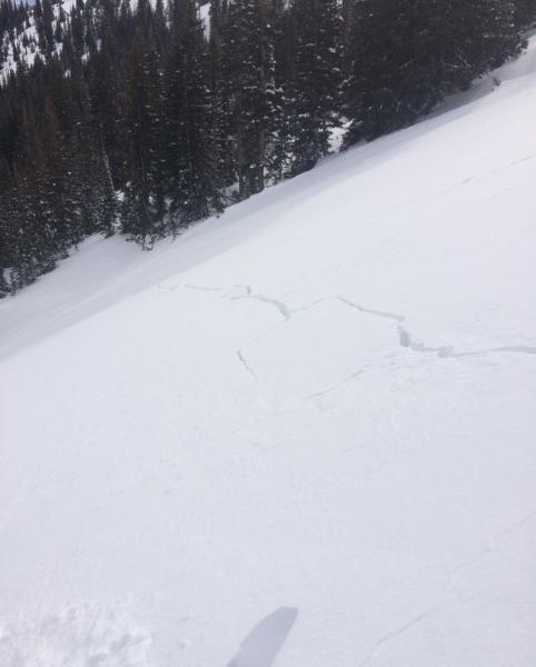
Lots of red flags out today. Didn't observe as many avalanches as I would have thought given the reports from yesterday. Did not observe any natural avalanches except for maybe W Monitor that would have had to have gone early in the storm. The slope looked very thin and similar to what it looked like Friday, but evidence of a crown or debris pile was very hard to see. If there was a natural cycle it seems it would have happened early in the storm to allow time to refill and hide the evedence. I was having some loud collapses but was not triggering anything remotely, even when trying to tickle some slopes that I though would be connected. When accessing stability on test slopes I was seeing pretty stuborn soft slab's finally starting to move on steeper slopes approaching 40*. I had lots of long shooting cracks, but again seemed stuborn and not starting to slide on slopes in the lower 30* range. I had one 150'x60' slab crack and pop on me 10' into the slab and move down the slope a few inches before arresting. I skied onto this slope cautiously and slowly and still managed to be ON the slab when it collapsed. This slab was about 14" thick and was failing on the density change from the Wednesday storm, or possibly on NSF just under that storm snow. It seems to me it was failing on the density change which would make more sense why they were a little stuborn and not running on low 30* slopes. It seems if the weak layer was facets it would have been a little more of a "hair trigger" type reaction, and possibly running faster and on lower angle slopes (ie 30* as oppose to 35*). I believe this can be pretty problematic because riders may find a false sense of stability due to the stuborness and choose to ski a slope, but when it finally goes the rider will be on the slab and not at the top.
Avalanche Problem #1
Problem
Wind Drifted Snow
Trend
Decreasing Danger
Problem #1 Comments
It seemed to me that the main issue is still the wind slab and storm slab issue. That being said I would think it would be very probable to trigger a wind or storm slab that would quickly step down to the weak faceted layers below the most recent storm's snow, going to the ground and resulting in a very high consequence outcome.
Avalanche Problem #2
Problem
Persistent Weak Layer
Problem #2 Comments
The persistent slab problem is still most concerning to me and I think is an issue right now in the right places. I would expect our snow pack to reach the tipping point here soon to activate these faceted weak layers, especially with the next storm on our doorstep.
Comments
All my observations from today were in a limited area on the Park City ridgeline and may not be indicative of what is going on in the central Wasatch as a whole. What I was seeing yesterday and today seems to differ quite a bit from what others were seeing yesterday, and I what I was expecting to see today. I like to increase my margins in situations like this when my uncertainty is high of what exactly is going on until I have a better understanding of what we are dealing with.
40* rocky convex roll test slope that was steep enough to get the slab moving.
Two pictures of large slab that popped and moved a few inches after I was already ON the slab, not initiated from above/top of the slab
***Note to forecasters, the third picture is oriented sideways
Today's Observed Danger Rating
Considerable
Tomorrows Estimated Danger Rating
None