Observation Date
4/9/2017
Observer Name
C Brown
Region
Salt Lake » Big Cottonwood Canyon » Days Fork
Location Name or Route
Days Fork, Cardiff Fork
Weather
Sky
Obscured
Precipitation
Light Snowfall
Wind Direction
Northwest
Wind Speed
Light
Weather Comments
Stayed cold most of the day. Sun didn't really pop until about noon and between then and 15:00 it was pretty much just ocansional sucker holes. Noticed some localized greenhousing for a short period a little after noon asending upper Days. Light to moderate snowfall during most of the day, about 4" between 8:00~15:00. Winds were light along some ridgelines, but otherwise prety calm.
Snow Characteristics
New Snow Depth
20"
New Snow Density
Medium
Snow Surface Conditions
Powder
Damp
Snow Characteristics Comments
Lots of new light to medium powder this morning. Seemed to be about 20"-24" above about 9k'. For looking at the wind data overnight was surprised to see not much wind effect where traveling today. Stayed off the bottom other than steeper south faces, but still phenomenal skiing!! Few inches of graupel above the old snow and a density change in the storm snow about 4-6"down. SSW seemed to be getting a little damp at 15:00, but East remained cold and skied great at 15:30.
Red Flags
Red Flags
Recent Avalanches
Heavy Snowfall
Cracking
Rapid Warming
Red Flags Comments
The main reactive snow today seemed to be a storm slab that was running on a density change about 4~6" deep. Largest pocket pulled out was maybe 30' wide and ran a little ways entraining surface snow but not steping down deeper into the new snow. These were very managable but could entrain a bit of snow and pull a skier off their feet and drag them. Seemed to only strart moving about 40* and steeper. Lots of cracking and shooting cracks at ~35* slopes but wouldn't run. Observed quite a few small slabs that appear to have ran during the storm probably on the graupel due to where they were (below cliffs on Cardiac and N Superior).
Avalanche Problem #1
Problem
Wet Snow
Trend
Increasing Danger
Problem #1 Comments
My main concern today was avoiding the solar slopes when the sun came out with this much new snow and this time of year. I was glad to see the sun obscured most of the day, but that leaves plenty of cold snow on the East aspects tomorrow that could be a problem in the morning.
Avalanche Problem #2
Problem
New Snow
Trend
Decreasing Danger
Problem #2 Comments
Not much of a cohesive slab, but just enough to have smaller pockets run today on the density change. Expect this to settle out overnight.
Comments
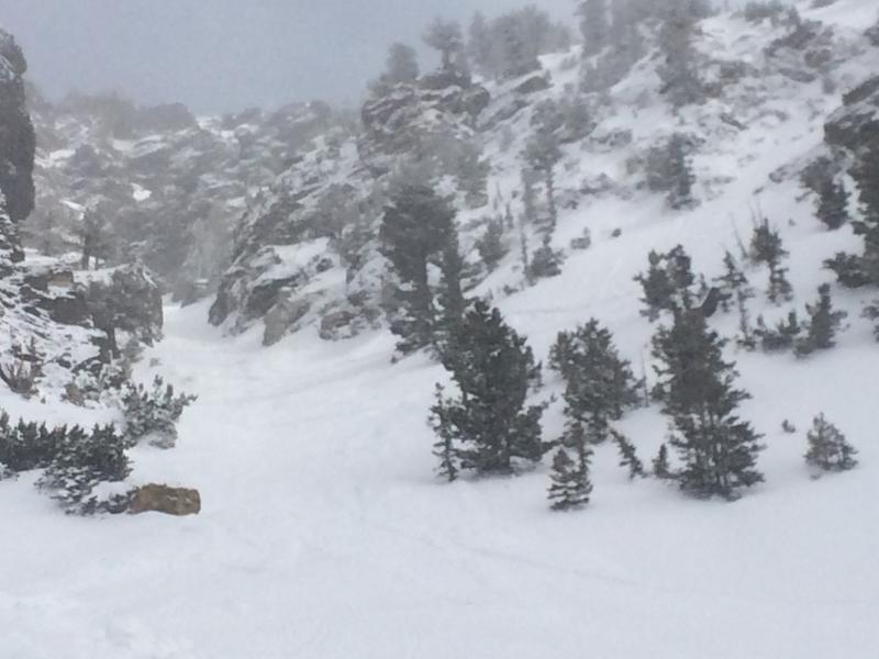
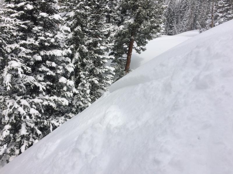
Picture of 6" deep, ~30' wide slab that came out while skiing and entrained a enough snow to grab me before cutting out of it (upper right of photo next to tree.) Picture of the soft slab storm slabs that were reactive today in second picture.
I would be most concerned with LW activity tomorrow with the amount of new snow and cold snow left to warm up with the strong April sun.
Today's Observed Danger Rating
Moderate
Tomorrows Estimated Danger Rating
Moderate