Observation: Rodeo Ridge

Observation Date
1/28/2017
Observer Name
Mike H
Region
Ogden » Ben Lomond » Rodeo Ridge
Location Name or Route
Rodeo Ridge
Weather
Sky
Few
Wind Direction
Northeast
Wind Speed
Calm
Weather Comments
Beautiful day in the Ogden Backcountry again. Today was in the 20's but the sun warmed things up while skinning. The colder temps kept the sun from affecting the snow to much. We stayed in low angle, lower elevation terrain so we were unable to look at steep upper elevation solar effects.
Snow Characteristics
New Snow Density
Low
Snow Surface Conditions
Powder
Dense Loose
Snow Characteristics Comments

Last night we were cold and clear and formed another new layer of surface hoar. At 4pm the sun nor wind had taken it down. We'll want to watch this through out the next week of high pressure weather. Great skiing can be found on all aspects of the compass right now !

Red Flags
Red Flags
Recent Avalanches
Red Flags Comments
We saw a natural avalanche cycle in the ogden mountains but things are begining to settle out. Some dry loose avalanches were seen near obviouse trigger points like exposed rocks and coming out from under large trees.
Avalanche Problem #1
Problem
Persistent Weak Layer
Trend
Decreasing Danger
Problem #1 Comments

We still have multiple persistent weak layers in our snowpack. The good thing is while some of the layers are reactive to compression tests (63cm down was the buried surface hoar), we received no results from ECTs on both Rodeo and cutler Ridge today in the 7000ft range on both NNE and ESE aspects. If you dig deep enough you can trigger a well consolidated slab that was reactive to shovel shears and failing on the Dec 16 rain crust that is very deep. These avalanches are getting harder and harder to trigger, but the consequences of triggering a deeper persistent layer would catostrophic.

Avalanche Problem #2
Problem
Normal Caution
Trend
Same
Problem #2 Comments

Lots of loose dry snow out there making for fantastic riding conditions, I hesitate to call it storm slabs as we are now 72hrs out from our last snowfall. Normal caution should be taken and consider the effects of not managing sluff or our soft snow problems that will potentially drag you into more consequential terrain.

Comments

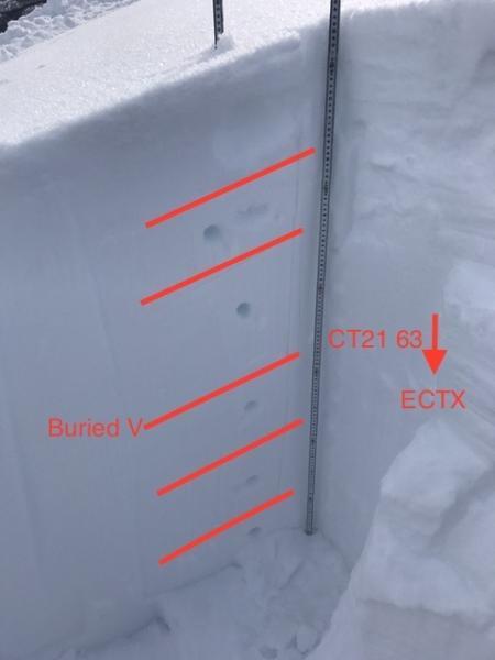
Photo 1 - snow profile of upper 150CM

​Video 1 - ECTX

Video 2 - CT21 SP down 63cm (Video shows 9 taps from the wrist. Ten were done, video just wasn't started yet.)

Video
Video
Today's Observed Danger Rating
Moderate
Tomorrows Estimated Danger Rating
Low