Get Your Ticket to the 32nd Annual Backcountry Benefit on September 11th! Support Forecasting, Awareness, and Education

Observation Date
12/3/2016
Observer Name
Greg Gagne
Region
Salt Lake » Big Cottonwood Canyon » Silver Fork
Location Name or Route
Silver Fork from BCC
Weather
Sky
Overcast
Wind Direction
Northwest
Wind Speed
Moderate
Weather Comments
Gusty winds out of the NW, but didn't notice any snow being transported.
Snow Characteristics
Snow Surface Conditions
Powder
Wind Crust
Melt-Freeze Crust
Snow Characteristics Comments

Was finding some very shallow sun crusts on SE aspects. Did not look at direct south aspects where a stouter crust may exist. Most every slope still has soft snow with excellent, supportable travel & riding conditions.

Avalanche Problem #1
Problem
Persistent Weak Layer
Trend
Decreasing Danger
Problem #1 Comments

Dug a few quick pits on upper elevation north aspects above Silver & Days forks. Elevations ranged from 9800' - 10200'. Snowpack 75-90 cms (2.5'-3').

The buried layer of facets on these slopes was much weaker than what I have been seeing elsewhere over this past week. I was finding a 10 cm (4") layer of dry, weak facets, whereas in other areas in both BCC and LCC I have been seeing a 5 cm faceted layer that is showing signs of strengthening. For me this simply confirms the spatial variability of the distribution of this faceted layer.

The strengthening slab on top of the facets is 4F or 1F.

No ECTs today. Compression tests could not produce any failures (CTN) and shovel shear tests were hard (STH), producing Q2 shears down in the faceted layer.

Overall am continuing to think triggering a slide on this faceted layer is unlikely as the slab above is currently not responsive to stability tests. However, the strong slab does allow people to get out onto a slope where it is possible to trigger a slide from a thinner area of the snowpack, such as around steep, rocky areas. The strong slab can then connect a slope, producing possibly larger avalanches.

Comments

Other than deep slab issues, per a discussion with Evelyn, was curious about the following today:

- Fresh wind drifting -> None observed.

- Weaknesses in the snow surface -> No surface hoar noted, also did not find any Radiation Recrystallization (RR) sitting on top of recent sun crusts. Perhaps some near-surface faceting, but overall the snow surface currently consists of either a crust on some solar aspects, or a few cms of light-density snow that fell on Friday.

- Weakening snow at the lower elevations -> This is a prime period for faceting, but even at lower elevations where there is a thinner snowpack, the snowpack remains supportable for travel, and I could not identify any weakening of the snowpack with quick hand pits.

Increasing winds will be the primary issue for the upcoming period.

Hazard is Low on all aspects and elevations other than on upper elevation north aspects where there is a Moderate hazard of triggering a deep slab avalanche. Sunday may be a different story with an rising hazard due to increasing winds - there is plenty of soft snow available for transport.

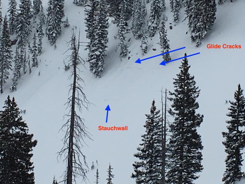
Poor quality photo - but found what has the appearance of a glide avalanche on the steep, north facing Silver Fork Headwall. Cracks and flanks were visible, as well what appears to be a stauchwall. However the slab largely stayed in place. Did not get that close to it for a better look, and photo is poor quality. This is a very steep, rocky slope that likely had a layer of facets underneath the recent storm snow. The issue is that this is not the type of terrain that produces glide avalanches, and this terrain often has both natural and skier-triggered slides that run a distance down the slope. Probably nothing more than the snow nerd in me.

Today's Observed Danger Rating
Low
Tomorrows Estimated Danger Rating
Low