Observation Date
3/7/2014
Observer Name
Ted Scroggin
Region
Uintas » Mirror Lake Highway
Location Name or Route
Mirror Lake Hwy-Bald Mt. Lofty Peak
Weather
Sky
Broken
Precipitation
Moderate Snowfall
Wind Direction
Northwest
Wind Speed
Moderate
Weather Comments
Winter like up high today with colder temps than we've had in awhile, moderate snowfall and gusty winds along the high ridge lines. There was brief periods of sunshine which took the chill-off a little.
Snow Characteristics
New Snow Depth
6"
New Snow Density
Medium
Snow Surface Conditions
Powder
Wind Crust
Snow Characteristics Comments
About 3-4" new at the trailhead and upwards of 6-8" around the Bald Mt. area and maybe another couple of inches fell throughout the day. The high Uintas have really filled-in and things are white. However, the winds have been all over the place, last weeks very strong southwest winds and today's northwest winds have worked over the high terrain. Very nice riding and turning conditions can be found in sheltered areas with a very supportable base.
Red Flags
Red Flags
Wind Loading
Cracking
Red Flags Comments
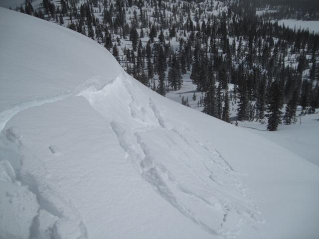
As is often the case in the higher terrain around Bald Mt. the winds have been blowing and moving snow around. Many of the north through east facing slopes were wind loaded from the southwest winds last week and now today's northwest winds were depositing snow onto east and southeast facing slopes, creating fresh soft wind slabs breaking up to a foot and a half deep on the high exposed ridge lines.
Avalanche Problem #1
Problem
Persistent Weak Layer
Trend
Same
Problem #1 Comments
In the high terrain today, the winds were creating fresh soft wind slabs on east through southeast facing slopes. Some of these were approaching the unmanageable size breaking a foot and a half deep. These could get out of hand on steep and unforgiving terrain.
Avalanche Problem #2
Problem
Persistent Weak Layer
Trend
Same
Problem #2 Comments
The Uintas are a huge area and many areas that have a thinner snow cover and rocky conditions are still likely areas where a deep avalanche can be triggered.
Comments
Fresh soft wind slabs along the high exposed ridge lines on southeast facing slopes were being formed today with gusty northwest winds. Some of these were breaking up to a foot and a half deep.
Today's Observed Danger Rating
Considerable
Tomorrows Estimated Danger Rating
Considerable


