Observation: Cardiff Fork

Observation Date
4/3/2025
Observer Name
Kelly, Worthen
Region
Salt Lake » Big Cottonwood Canyon » Cardiff Fork
Location Name or Route
Cardiff- South Facing LCC
Weather
Sky
Obscured
Precipitation
Heavy Snowfall
Wind Direction
South
Wind Speed
Light
Weather Comments
Obscured to overcast skies for most of the tour. Winds were light from the southeast-south-southwest, but not transporting any snow along the ridgetops. Air temperatures were in the mid teen's °F at nearby weather stations.
Snow Characteristics
New Snow Depth
9"
New Snow Density
Low
Snow Surface Conditions
Powder
Snow Characteristics Comments
8"-10" of settled new snow fell during the day which stacked up to anywhere from 18"-22" of settled snow depth since April 1. The new snow was mostly low density fluff and between 1pm and 3pm some stations recorded 2"- 3" an hour snowfall rates.
Photo of snow that stacked up during a ten minute water and snack break, between this run and the run before it there was easily an additional 4" of new snow on the skin track.
Red Flags
Red Flags
Recent Avalanches
Heavy Snowfall
Avalanche Problem #1
Problem
New Snow
Problem #1 Comments
Today, we observed a number of new snow avalanches failing on a density change. These were anywhere from 4"-12" deep and many had crown faces that had been filled back in. We also triggered a soft slab avalanche failing on a density change on an east facing slope 12" deep running above the melt freeze crust. This was intentionally skier triggered on a steep roll over and was 50' wide and ran 100' vertical taking all the new snow (entraining) with it, and we intentionally triggered a soft slab avalanche on a south facing slope at 10,000' that was 8"-10" deep and ran 200' vertical entraining the newest snow and piling up in a gully.
Photo of natural avalanches on north-east facing slopes around 10,000'. These were shallow 4"-6" deep new snow avalanches failing on a density change.


Comments
What we saw today was soft slab new snow avalanches failing on a density change within the newest snow and had to do with strong snowfall (precipitation) intensity. The density changes (heavier and lighter snow falling out of the sky) within the newest snow were the weak layers. These will typically settle out quickly, but if allowed to entrain a lot of the new snow they can be larger than you may expect particularly on steep long running slopes where snow can pile up on benches and in gully features. Today the tails of my skis were still hitting the melt-freeze crust in some locations, but the avalanches were failing on a density change in the recent storm snow above the crust.
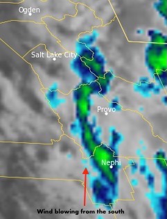
Photo taken just before snowfall tapered off showing radar (band 13) with snowband (greens and blues)
Today's Observed Danger Rating
Moderate
Tomorrows Estimated Danger Rating
None
Coordinates