The snow on northerly aspects near treeline and below is very weak and faceted. We are experiencing above average temperatures for this time of year. I was curious about the potential for wet slab activity on these slopes. In my travels today I found the snow on low elevation northerlies to be cold and dry, with no signs for potential wet activity. I found very weak snow on a north facing slope at 10,310'. See the video below.
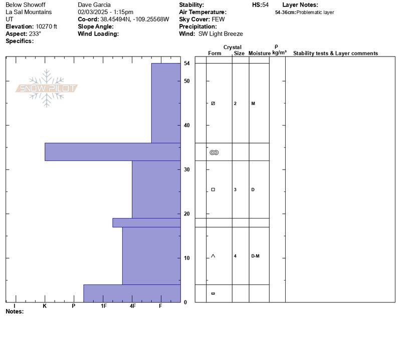
I also looked at a SW facing slope at 10,270' below Showoff. I found the surface snow was moist. I could easily make a snowball with this snow, but water was not visible, and I could not squeeze any water out of the snow. It is obvious this snow has gained some density from the sunshine and warm temperatures, but so far it is not alarming. I observed no roller balls or other signs of wet activity today. By tomorrow, loose wet activity could develop on steep rocky solar aspects, but these slides will be small, confined to the surface snow, and somewhat isolated. I don't think you will get into too much trouble on solars tomorrow as long as you pay attention to the moisture content of the surface snow. The snow below the surface remains cold and dry, with no danger yet for wet slab activity. The trend for loose wet will continue to increase as long as temperatures stay warm. It looks like things will cool down after Thursday.
I experienced a small collapse in a flat meadow around 10,200'. Here the surface snow had taken on some heat from the sun and warm temperatures. The surface snow is just slightly more cohesive than the weak, cold facets directly below it. This is illustrated in the photo below. In some places, the surface snow will continue to gain cohesion as long as temperatures stay warm.


