Join us at our 2nd Annual Blizzard Ball

Observation: Blue Ice

Observation Date
1/17/2025
Observer Name
Trenbeath, White
Region
Salt Lake » Big Cottonwood Canyon » Broads Fork » Blue Ice
Location Name or Route
Broads Fork
Weather
Sky
Overcast
Wind Direction
West
Wind Speed
Moderate
Weather Comments
We started out with mid level cloudiness and light to moderate westerly winds. A few gusts around 11:00 a.m. gave us the impression that we would see a signifiant increase as the day progressed but it never really materialized. Overall light with moderate gusts but we never approached high ridge lines. Cloud ceiling dropped as the day progressed eventually settling around 9500' around 3:00 p.m.
Snow Characteristics
Snow Surface Conditions
Powder
Faceted Loose
Snow Characteristics Comments
Snow surface was soft through the areas we traveled including westerly aspects. It was also faceting in the top few inches. Light wind affect was observed around 9000'.
Red Flags
Red Flags
Recent Avalanches
Poor Snowpack Structure
Red Flags Comments
We observed another glide avalanche in Bonkers that covered up the debris from a slide previously reported by Mark White. Seems strange for this time of year but fresh rock slabs were clearly exposed.
Avalanche Problem #1
Problem
Persistent Weak Layer
Problem #1 Comments
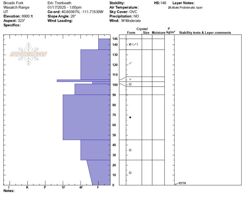
We dug a pit on a sheltered NNW, aspect at 8900' and found a deeper than average (145 cm) snowpack for this elevation. Basal facets remain at the base of the snowpack with a strong, 1f slab above. An extended column test produced no results (ECTX) but there was more than a meter of snow above the weak layer thereby reducing the efficacy of the test. By removing about half of the overriding snow, I was able to produce results of ECTP 11 failing on the the basal facets. Anecdotally, this leads me to believe that avalanches are more likely to be triggered in shallower snowpack areas that have 100 cms or less. This coincides with the recent spate of human triggered avalanche activity. Where the snowpack is upwards of a 140 cms or more, it will be harder to affect the weak layer.
Snow Profile
Aspect
Northwest
Elevation
8,900'
Slope Angle
28°
Comments
I've been observing the Wasatch snowpack history from afar and this was my first day out in the field up here. It's my impression that the PWL presents the greatest danger on steep northerly aspects where the snowpack is right around 100 cms or less. Terrain also seems to play a significant roll. In addition to steepness, a certain amount of "scrappyness" or complexity seems to be a contributing factor as well. Steep, rocky slopes with convex features, or even sparse trees seem the most likely areas to trigger an avalanche. Broad, planar slopes, especially those with a deeper snowpack seem less likely. It is, however, a bit like rolling the dice. For our part, we continued to avoid slopes much more than 30 degrees.
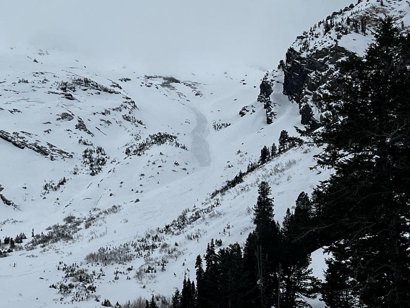
Fresh glide avalanche in Bonkers.
Today's Observed Danger Rating
Moderate
Tomorrows Estimated Danger Rating
Moderate
Coordinates