Observation Date
1/21/2024
Observer Name
Magerl
Region
Skyline » Fairview Canyon
Location Name or Route
White Pine Fork
Weather
Sky
Overcast
Precipitation
Light Snowfall
Wind Speed
Light
Weather Comments
Moderate temperature all day, and very light wind. Low clouds by noon limited the visibility. Light snowfall off and on throughout the day, no accumulation. Spitty snow started at 4 P.M.
Snow Characteristics
New Snow Depth
2"
New Snow Density
Medium
Snow Surface Conditions
Dense Loose
Snow Characteristics Comments
Moderately dense snow. Very supportable surface, predictable turns. A bit heavy as the more moist snow started to fall late in the day. Very easy to set skin track.
Red Flags
Red Flags
Poor Snowpack Structure
Red Flags Comments
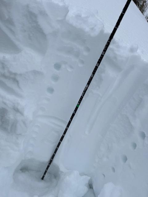
Dug a pit at 9,000, east facing. Total depth 125 cm. Four finger top 20 cm to one finger for the next 30 cm to a stout layer75 cm from the ground, 50 cm from the top. Then pencil for 30 cm to total loose unconsolidated. You could squeeze that loose snow all you wanted and it would not bond to itself. Isolated a column, and it was stubborn. When forced to fail, it broke as one clean block of 80 cm, failing on the sugary persistent weak layer. Disturbing to think about this hard slab breaking loose. It wouldn't be like being in a washing machine, it would be like taking a tumble as dozens of washing machines rained down around you.
Found sugar in the bottom 45 cm to 55 cm throughout this area.
Avalanche Problem #1
Problem
Persistent Weak Layer
Problem #1 Comments
Did several slope cuts on very low risk roll-overs steeper than 30. Nothing was reactive. But the basement is full of junk. Will feel uneasy about anything steeper than 30 until this heals.
Comments
Before the cloud ceiling dropped, could see some slide activity through the spotting scope. One of note on the NW-facing knob at 9,600', above GE Hill, that slid to the ground. Unsure when it went. On drive down Fairview Canyon at 4:15 P.M., rollerballs galore on the south-facing road cut.
Today's Observed Danger Rating
Considerable
Tomorrows Estimated Danger Rating
Considerable