Observation: Puffer Lake

Observation Date
1/16/2023
Observer Name
Ian Dempsey
Region
Southwest » Tushers » Puffer Lake
Location Name or Route
Tushars - Puffer Lake
Weather
Sky
Overcast
Wind Speed
Calm
Snow Characteristics
New Snow Depth
14"
New Snow Density
Medium
Snow Surface Conditions
Powder
Red Flags
Red Flags
Heavy Snowfall
Poor Snowpack Structure
Red Flags Comments
I saw cracking in a single spot and I saw a single slide (R1D2 - large enough to bury a small human) likely at the new/old snow interface on a steep 40ish degree north facing slope about 1/4 mile from my pit location. It appeared to have occurred naturally, perhaps last night or yesterday as it was covered in fresh snow.
Avalanche Problem #1
Problem
New Snow
Trend
Increasing Danger
Problem #1 Comments
The 35 cm of storm snow seems to be bonding well to the old snow surface. My CT on a 27 degree slope did get a resistant planar (RP) fracture at 15 taps and when I tried to pull it off the column it broke apart. As noted above I also observed a small R1D2 slide relatively close to my pit location in what appeared to be the new/old snow interface. It was snowing heavily by the time I made it back to my car, and the temperature appeared to be dropping, so hopefully any new accumulation will be lower density. The new/old snow interface is something to watch as more snow accumulates, especially if there is a turn towards higher density snowfall in the new accumulation.
Avalanche Problem #2
Problem
Persistent Weak Layer
Trend
Decreasing Danger
Problem #2 Comments
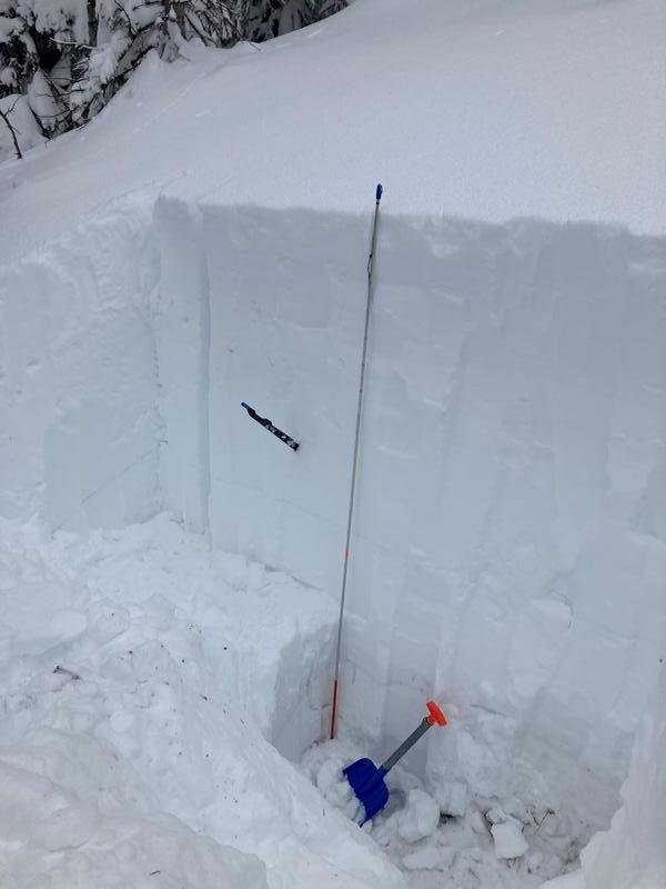
It's hard to even call this a problem, but to be on the conservative side, it is worth noting that the snowpack does have a poor structure. It is very deeply buried the layer is 10-50 cm above the ground in a 230 cm snowpack - almost a full two meters beneath the surface). If this were to fail it would be massive. I did not test this layer in my CT or ECT as I would probably need to use a different snow stability test to try to get any results. The layer consists of 2mm rounding facets fist hard on the hand hardness scale. As UAC forecasters have noted this layer is healing slowly and could be triggered in a thin spot in the snowpack, but it is gaining stability as the snow keeps piling up.
Another interesting finding was that there was a pretty stout ice crust at 107 cm above the ground.
Snow Profile
Aspect
North
Elevation
10,200'
Slope Angle
27°
Video
Today's Observed Danger Rating
Considerable
Tomorrows Estimated Danger Rating
Considerable